
- For this month’s focus on technology, let’s take a look at several recent advancements in the biofuel industry.Bacteria are often the powerhouse that convert raw biomatter to ‘fuel.’ This research has bioengineered E. coli to convert biomatter to long-chain fatty acids which are the precursors of gasoline. These researchers have inserted tree enzymes into bacteria in order to produce pinene, a high-octane hydrocarbon that could replace rocket fuel. And this research inserts a bacterial gene into E. coli to increase the efficiency of biofuel production by strengthening the cells.
Increasing the sources of biomatter will obviously make biofuels more sustainable as the use of them grows; and so here are two ideas for new sources: coffee grounds and alligator fat. Finally, improving the efficiency of biofuel production can also include pathways other than conversion by microorganisms. For instance, this research which uses solar energy to create synthetic fuels; this idea uses an acid wash to produce acetone from corn husks; or this technology to convert ethanol to transportation-ready fuels.
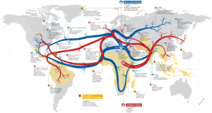 Map showing the spread of leprosy, malaria and small pox across the globe as well as an indication of the time of infection.
- Maps often paint pictures we cannot with words alone. And here is a map that is no exception to the rule. It shows the spread of malaria, leprosy and small pox across the world from their points of origin. While leprosy and small pox have been eradicated, malaria still kills at least 1 million people per year.
- I am not what you would call an outdoorsy person, but I do respect nature! And in honor of warm weather activities, this month I Googled, “fishing and GIS.” Here is an interesting PowerPoint put together by Wedell (Oregon State University) and Revell (U California Santa Cruz) that shows the power of GIS for community-based fisheries management. In this study, the authors employ participatory GIS to gauge local knowledge of fishing habitats, use of these areas and (of course) to create maps.
- From the Gulf of Mexico, we travel to the northeastern edge of our country with an exploration of Portland, Maine’s GIS resources. The City of Portland GIS offers both a web application and PDF versions of the maps they produce. There are more than 60 PDFs that can be viewed and downloaded from this page, however the vast majority of the links seem to be broken. The GIS department also created 12 online maps of various themes including a parcel viewer that lets users search for a parcel and then query detailed assessor information. The online maps also let you print your current screen view. Finally, you can download the ArcGIS mobile app, search for Portland Maine and then view parcel and planning data on your smartphone.
Brock Adam McCarty
Map Wizard
(720) 470-7988
brock@apollomapping.com
This entry was posted in The Geospatial Times and tagged biofuel, geography matters, News Snippets Bookmark the permalink.

Leave a Reply