
-
- Our first technology review of the year, sweet! Let’s jump right in
Biofuel & Solar: This ruthenium-based catalyst might be the key to converting biomass to plastic. Researchers discovered that random holes in solar cells can increase their efficiency by studying black butterfly wings; while this fractal-based concentrator could increase solar efficiency by 20%.Random: Here is a new rice variety that can grow in diluted saltwater which opens up marginal lands for agriculture. Discarded plastic bottles make concrete stronger; while discarded cigarette butts could power our next-generation fuel cells. This living wallpaper has a gorgeous green stripe made of cyanobacteria that also produces power from the Sun. And finally, forget about nuclear fusion, that’s old school, now it’s all about quark fusion that can yield up to 10 times the energy!
- Our first technology review of the year, sweet! Let’s jump right in
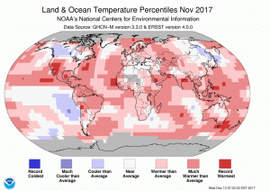 The November 2017 temperature departure map shows warm conditions across the world’s land masses with some cooler temperatures across western Canada and eastern Asia.
- The November NOAA Global Climate report confirms that warm temperatures dominate the globe with a large pocket of record warmth over the southwest of the USA. November 2017 was the fifth warmest November on record and the 395th consecutive month over the 20th Century temperature average. Eventually the world will do something to solve this global crisis even if the United States decides not to do its part at the federal level.
- The Emancipation Proclamation became law on January 1, 1863 and to commemorate this event, my Google search of the month was, “GIS and Emancipation Proclamation.” If you go through the various results, you might find this highly interactive and informative web map about the end of slavery put together by a team supervised by Scott Nesbit of University of Richmond. This map lets you understand the visual patterns of slavery as well as the collapse of the Confederate forces – excellent work on this project!
- Last month we hoped to find a GIS page for Hawaii’s second largest city, Pearl City, but we failed; and this month we try again with Idaho’s second largest city, Nampa. And while it is not a great website, at least they have one that can be found here. In general, the GIS website is little more than a collection of PDFs that can be accessed at the bottom of the page – with a few more on the assessor site here. Maybe we will have better luck with robust GIS websites when we head back into large states!
Brock Adam McCarty
Map Wizard
(720) 470-7988
brock@apollomapping.com

Leave a Reply