
- If you read this article often, you know that we always start off with fun technological advancements from the past weeks, so here we go with that list again!
Tiny copper flowers create useable carbon products from the sun and water.
An approach to recycle before impossible-to-recycle materials.
Another method to create sustainable fuel from ambient carbon dioxide and sunlight.
While this technique produces hydrogen fuel without carbon dioxide emissions.
A sustainable alternative to plastic.
Who would have thought that cigarette butts can clean wastewater?
Extracting drinking water from thin air with natural materials.
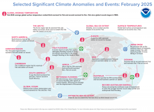
In May 2025, the Arctic region had its warmest February and winter on record. North America tied as the third warmest winter on record. The Hawaiian region had its warmest February and winter on record. The Caribbean region had its warmest February and winter on record. Antarctic sea ice extent was the third lowest on record. Oceania had its second warmest February and warmest December-February on record. (Image Credit: NOAA Global Climate Report)
- The NOAA Global Climate Report for February 2025 has been released by the National Centers for Environmental Information and reveals further proof that global Climate Change remains a concern. The global surface temperature was 2.27°F above the 20th Century average of 53.8°F, making it the third warmest February on record. It was the fourth warmest February for the global land air temperature and the second warmest February for the global ocean surface temperature. The Northern Hemisphere had its fourth warmest February on record at 2.90°F above average. The Northern Hemisphere land-only temperature also was fourth warmest while the Northern Hemisphere ocean-only temperature was second warmest on record for February. Temperatures in the Southern Hemisphere ranked second warmest on record at 1.64°F above average. The average ocean-only and land-only temperatures for February in the Southern Hemisphere also individually ranked second warmest on record. There were areas of drier-than-average conditions covering much of Europe, eastern Kazahkstan stretching eastward through southern Mongolia into eastern China and the southern two-thirds of Japan. Below average precipitation also occurred in a large part of Australia, East Africa westward to Atlantic coastal areas of Central Africa, the southern half of Brazil, Bolivia, Paraguay and northern Argentina, as well as a large part of Canada, southern Alaska, the central U.S. and much of the southern U.S. southward into a large part of Mexico.
- April Fool’s Day falls on the first of the month and many people have fallen victim to a prank or two. In 2015, The Winnipeg Sun pulled a big one over on readers. The newspaper ran an article about a proposed plan from the provincial government to begin issuing GPS-tracked speeding tickets the following year. As you can imagine, numerous readers were furious about the proposal. One reader even called the newspaper to say he had called the mayor’s office and several MLAs to express his dismay with the alleged plan, then admitted he didn’t read to the bottom of the story, which made it fairly clear it was a prank. Others mostly appreciated the prank article – which was listed as having been written by Roger L. Easton, the primary inventor of GPS – even if they didn’t immediately catch on. “Thanks for getting my blood boiling,” wrote one reader. “I was ready to move if this was actually going to happen in Manitoba.” On April 1, 1977, the Guardian produced a seven-page travel supplement about the tiny tropical republic of San Serriffe, “a small archipelago, its main islands grouped roughly in the shape of a semicolon, in the Indian Ocean,” which was apparently celebrating 10 years of independence. The article included a GIS map of the island republic. The country was in fact completely made up as an April Fool’s joke. GIS was also used to create a fictitious map released for April Fool’s Day. Mac Studio teased blog readers with an unveiling of ArcGIS for macOS, which Map Happenings debunked.
Brock Adam McCarty
Map Wizard
(720) 470-7988
brock@apollomapping.com
This entry was posted in The Geospatial Times and tagged apollo news, News Snippets, The Geospatial Times Bookmark the permalink.

Leave a Reply