
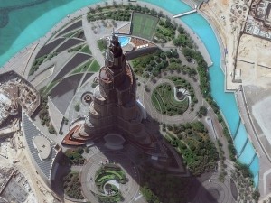
 An amazing 40-cm color WorldView-3 image of the world’s tallest building, Burj Khalifa, in Dubai, United Arab Emirates collected on September 19, 2014. Check out the shadow cast by the four-headed light fixture over the tennis courts. (Image Courtesy: DigitalGlobe)
 Zabel Park from the same 40-cm WorldView-3 image collected over Dubai. The detailed, colored veins you can see on the five rocks is absolutely incredible. (Image Courtesy: DigitalGlobe)
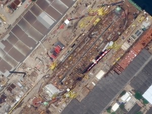 A ship unloading in the docks of Rio de Janeiro, Brazil. This 40-cm WorldView-3 image collected on October 23, 2014 is detailed enough to show the steel lattice structure of the shipyard cranes. (Image Courtesy: DigitalGlobe)
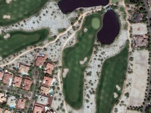 And finally, a WorldView-3 image collected on September 5, 2014 over Verrado Golf Course, Arizona. With 40-cm resolution, golf carts are more than a speck and you can even start to make out individual roof tiles that are different colors. (Image Courtesy: DigitalGlobe)
We cannot get enough of this amazing 40-cm WorldView-3 (WV3) data and we hope you agree! So this month, we feature four color images from the United States, Brazil and the United Arab Emirates. If you have not heard of the recently-launched satellite, WorldView-3, here are the features that really set it apart from the competition:
-
- Improved Resolution
- Higher resolution means you can see more detail in WV3 imagery.
- Data collected at nadir will have 31-centimeter (cm) panchromatic, 1.24-meter (m) visible and near infrared, 3.7-m short-wave infrared and 30-m CAVIS bands.
- At 20 degrees off-nadir, the resolution is 34-cm panchromatic, 1.38-m visible and near infrared and 4.1-m short-wave infrared.
- With the easing of US government regulations, we will be able to provide WV3 imagery at a maximum of 30-cm resolution during Q1 2015.
- Additional Spectral Bands
- If spectral analysis is part of your project, then no other satellite can match WV3 with its: 8 bands of visible and near-infrared data; 8 shortwave infrared bands which are crucial for geological studies; and 12 CAVIS bands to detect water vapor, dissolved aerosols, snow, clouds and more.
- Better Positional Accuracy
- With accuracies of 3.5-m CE90% or better (without ground control even!), WV3 has no rivals for its enhanced positional accuracy.
- Daily Revisits
- At 40 degrees latitude, WV3 will be able to image each location daily with 1-meter or better resolution and then every 4.5 days at 34-cm resolution or better.
- Increased Collection Capacity
- WV3 features a 13.1-km swath width (at nadir) with the ability to collect up to 680,000 square kilometer (sq km) of high-resolution data per day.
- Improved control movement gyros translate into larger maximum contiguous collection areas per pass, with up to ~7,500 sq km of mono imagery and ~3,000 sq km of stereo possible.
- Improved Resolution
If you are interested in WorldView-3 imagery for your next project, please let us know by phone, 303-993-3863, or by email, sales@apollomapping.com.
This entry was posted in The Geospatial Times and tagged 40-cm, monthly spotlight, WorldView-3 Bookmark the permalink.

Demand collaboration