
Every time we look at WorldView-3 (WV3) imagery, we are blown away. And we hope you are equally impressed with the data! For August, we feature three color 30-centimeter (cm) WV3 images collected over my hometown of Baltimore, Maryland in the USA.
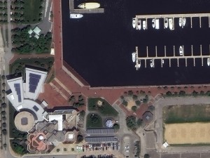
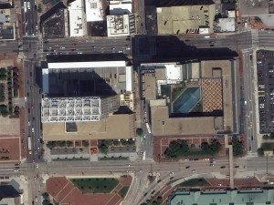

Baltimore, Maryland is known for its downtown which rings the Inner Harbor of the Chesapeake Bay. The three photos here are taken close to the Bay. The first is of M&T Bank Stadium which is home to the Baltimore Ravens. The second is the Maryland Science Center which is located right on the waterfront. And the last image is of two interesting buildings located across the street from the Harborplace. These 30-cm color WorldView-3 images were collected on June 8, 2015. Imagery photo enhanced by Apollo Mapping. (Images Courtesy: DigitalGlobe)
WorldView-3 was launched in late 2014 and is the most advanced satellite the commercial marketplace has ever had access to. Here are a few of the features that really set it apart from the competition:
- Improved Resolution
- Higher resolution means you can see more detail in WV3 imagery.
- Data collected at nadir will have 31-centimeter (cm) panchromatic, 1.24-meter (m) visible and near infrared, 3.7-m shortwave infrared (SWIR) and 30-m CAVIS bands.
- At 20 degrees off-nadir, the resolution is 34-cm panchromatic, 1.38-m visible and near infrared and 4.1-m shortwave infrared.
- Per US government regulation, all SWIR orders are produced at a maximum resolution of 7.5-m. CAVIS bands are not available for purchase at this time.
- Additional Spectral Bands
- If spectral analysis is part of your project, then no other satellite can match WV3 with its: 8 bands of visible and near-infrared data; and 8 shortwave infrared bands which are crucial for geological studies.
- Better Positional Accuracy
- With accuracies of 3.5-m CE90% or better (without ground control even!), WV3 has no rivals for its enhanced positional accuracy.
- Daily Revisits
- At 40 degrees latitude, WV3 will be able to image each location daily with 1-meter or better resolution and then every 4.5 days at 34-cm resolution or better.
- Increased Collection Capacity
- WV3 features a 13.1-km swath width (at nadir) with the ability to collect up to 680,000 square kilometer (sq km) of high-resolution data per day.
- Improved control movement gyros translate into larger maximum contiguous collection areas per pass, with up to ~7,500 sq km of mono imagery and ~3,000 sq km of stereo possible.
If you are interested in WorldView-3 imagery for your next project, please let us know by phone, 303-993-3863, or by email, sales@apollomapping.com.
You can also find more samples and technical information on our website here.
This entry was posted in The Geospatial Times and tagged 30cm color, DigitalGlobe, featured products, high resolution, product updates, The Geospatial Times, WorldView-3 Bookmark the permalink.

Leave a Reply