
Every time we look at WorldView-3 (WV3) imagery, we are blown away. And we hope you are equally impressed with the data! From the island nation of Japan, we travel across the globe to another island nation with a look at Varadero, Cuba for the WV3 Image of the Month.
WorldView-3 was launched in late 2014 and is the most advanced satellite the commercial marketplace has ever had access to. Here are a few of the features that really set it apart from the competition:
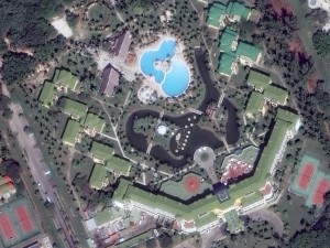
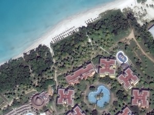
 It’s winter here in Colorado so what better to do than daydream about warm tropical locations like Varadero, Cuba. These 30-cm WorldView-3 images were collected on November 13, 2015 over the island resort town. My personal favorite is the second image with the beach included, I call a front row umbrella right now! (Image Courtesy: DigitalGlobe)
- Improved Resolution
- Higher resolution means you can see more detail in WV3 imagery.
- Data collected at nadir will have 31-centimeter (cm) panchromatic, 1.24-meter (m) visible and near infrared, 3.7-m shortwave infrared (SWIR) and 30-m CAVIS bands.
- At 20 degrees off-nadir, the resolution is 34-cm panchromatic, 1.38-m visible and near infrared and 4.1-m shortwave infrared.
- Per US government regulation, all SWIR orders are produced at a maximum resolution of 7.5-m. CAVIS bands are not available for purchase at this time.
- Additional Spectral Bands
- If spectral analysis is part of your project, then no other satellite can match WV3 with its: 8 bands of visible and near-infrared data; and 8 shortwave infrared bands which are crucial for geological studies.
- Better Positional Accuracy
- With accuracies of 3.5-m CE90% or better (without ground control even!), WV3 has no rivals for its enhanced positional accuracy.
- Daily Revisits
- At 40 degrees latitude, WV3 will be able to image each location daily with 1-meter or better resolution and then every 4.5 days at 34-cm resolution or better.
- Increased Collection Capacity
- WV3 features a 13.1-km swath width (at nadir) with the ability to collect up to 680,000 square kilometer (sq km) of high-resolution data per day.
- Improved control movement gyros translate into larger maximum contiguous collection areas per pass, with up to ~7,500 sq km of mono imagery and ~3,000 sq km of stereo possible.
If you are interested in WorldView-3 imagery for your next project, please let us know by phone, 303-993-3863, or by email, sales@apollomapping.com.
You can also find more samples and technical information on our website here.
This entry was posted in The Geospatial Times and tagged 30-cm, Cuba, image of the month, monthly spotlight, WorldView-3 Bookmark the permalink.

Leave a Reply