
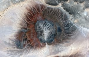
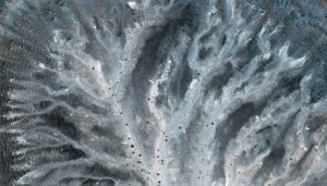
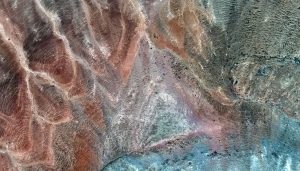

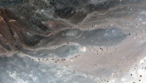
 Al Wahbah crater is located in west-central Saudi Arabia about 200 kilometers (km, or ~124 miles) from the Red Sea. Once thought to be the result of a meteorite strike, it is now thought to be the result of an enormous eruption of molten magma heated steam. The images featured here are of a crater located about 25 km (15.5 miles) southwest of Al Wahbah. The first image is a resampled 2-m view of the entire crater, while the other four images are featured at full 30-cm resolution. The colors depicted in these WorldView-3 images are absolutely insane – particularly the blue tones. These 30-cm WorldView-3 images were collected on August 16, 2015 and have been enhanced by Apollo Mapping for improved colors and clarity. (Images Courtesy: Maxar)
Every time we look at WorldView-3 and WorldView-4 (WV3/4) imagery, we are blown away. And we hope you are equally impressed with the data! Last month’s edition of this regular piece found us deep in an Asian urban landscape, and for the February 30-cm Color WorldView-3/4 Image of the Month we travel into the countryside of Saudi Arabia with a look at literally the exact opposite landscape, a remote desert crater.
PLEASE NOTE: Effective May 2016, WorldView-3/4 prices dropped again! Are you interested in finding out more about these price drops? If so, send us an email at sales@apollomapping.com.
WorldView-3 launched in late 2014 and WorldView-4 launched in late 2016; taken together they are the most advanced satellite constellation the commercial marketplace has ever had access to. Here are a few of the features that really set these satellites apart from the competition:
- Improved Resolution
- Higher resolution means you can see more detail in WV3/4 imagery.
- Data collected at nadir will have 31-centimeter (cm) panchromatic, 1.24-meter (m) visible and near infrared, 3.7-m SWIR (WV3 only) and 30-m CAVIS (WV3 only) bands.
- At 20 degrees off-nadir, the resolution is 34-cm panchromatic, 1.38-m visible and near infrared and 4.1-m shortwave infrared.
- Additional Spectral Bands
- If spectral analysis is part of your project, then no other satellite can match WV3 with its: 8 bands of visible and near-infrared data; and 8 shortwave infrared bands which are crucial for geological studies.
- Better Positional Accuracy
- With accuracies of 3.5-m CE90% or better (without ground control even!), WV3/4 has no rivals for its enhanced positional accuracy.
- Daily Revisits
- At 40 degrees latitude, WV3 is able to image every location daily with 1-meter or better resolution and then every 4.5 days at 34-cm resolution or better.
- WV4 is no longer collecting new imagery.
- Increased Collection Capacity
- WV3/4 feature 13.1-km swath widths (at nadir) with the ability to collect up to 680,000 square kilometer (sq km) of high-resolution data per day per satellite (though WV4 is dead now).
- Improved control movement gyros translate into larger maximum contiguous collection areas per pass, with up to ~7,500 sq km of mono imagery and ~3,000 sq km of stereo possible.
If you are interested in WorldView-3 and/or WorldView-4 imagery for your next project, please let us know by phone, 303-993-3863, or by email, sales@apollomapping.com.
You can also find more WV3 samples and technical information on our website here and then WV4 samples and information can be found here.

Your website is a living ACADEMY of GIS and everything associated with it