
A map of all SPOT 6 collections since its launch as well as those with less than or equal to 10% cloud cover. In all, SPOT 6 has collected nearly 400 million square kilometers (sq km) of coverage in less than a year.
In the past two years, Astrium GEO has launched three satellites which have already proven their capabilities to tasking large areas in time frames shorter than possible in the past. In this article, we would like to highlight three collection scenarios – one for the medium resolution satellite, SPOT 6 which launched September 9, 2012, and then two for the high-resolution Pléiades 1 constellation with individual launches in 2011 and 2012.
If you have any questions about the technical specifications and/or pricing of SPOT 6 and Pléiades 1, please contact the Apollo Mapping Sales team at sales@apollomapping.com.
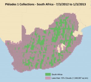 In just six months, Pléiades 1A (just half the constellation) imaged well more than half of South Africa with 15% or less cloud cover. With both satellites imaging the country, a full collection would have been possible in the same time frame.
 In ten months, the Pléiades 1 constellation (and most of the time only P1A) imaged the entire 4,400-km plus border of Saudi Arabia with 15% or less cloud cover.
This entry was posted in The Geospatial Times and tagged Astrium-Geo, monthly spotlight, Pleiades 1, SPOT 6 Bookmark the permalink.

Leave a Reply