
In this monthly feature, we span the globe to examine Our Changing Landscape with a time series of medium-resolution PlanetScope satellite imagery. The PlanetScope constellation dates back to 2016 and collects hundreds of millions of square kilometers of four and eight-band 3-meter imagery daily! In December we took in Derna, Libya and the devasting flooding there. This month, we’re look at Hurricane Otis and its wide-reaching impact on Acapulco, Mexico.
The PlanetScope Microsat Constellation
 Click on the image above to see an animation of 3-meter natural color PlanetScope imagery collected over Acapulco, Mexico on October 23 and 27, 2023–both images collected just days before and after Hurricane Otis. And continuing in the disturbing trend started last month with the Derna flooding, these two images really speak for themselves. When Hurricane Otis made landfall in Acapulco the destruction was just simply immense as it tore out vegetation, flattened homes and left significant flooding in its wake. While the official death toll stood at 27 when this article was drafted, it is our feeling that number is vastly underestimated. The devastation is just so stark–our thoughts are with this region as it rebuilds over the coming years. (Images Courtesy: © Planet 2023)
PlanetScope is a constellation of more than 240 microsats referred to individually as Doves. Each Dove is able to collect up to 20,000 square kilometers (sq km) per day of 3-meter (m) 4-band multispectral (i.e. blue, green, red and near-infrared [NIR]) imagery; and newly launched SuperDoves collect 8-band multispectral adding in valuable red-edge spectral data. Across the constellation, PlanetScope is archiving more than 200 million sq km of medium-resolution imagery a day, making it the go to source for daily imagery over most locations. This massive archive dates back to 2016, offering the most complete and continuous record of spatial data on the planet since the start of the constellation’s ongoing launch schedule. Collecting 3-meter multispectral imagery is the equivalent of ‘high-resolution’ multispectral data imaged by a 75-centimer (cm) satellite (as this satellite would feature 75-cm panchromatic and 3-m multispectral), making PlanetScope an extremely competitively priced option at just $2.25 per sq km. With well registered images and nearly daily collections of most locations, PlanetScope is the ideal imagery source for this current-events focused series, Our Changing Landscape.
October 2023 Hurricane Otis & Its Impact On Acapulco, Mexico
Hurricane Otis made landfall on October 25, 2023 in Acapulco, Mexico as a Category 5 hurricane with sustained winds of 165 miles per hour. More than one million people around the city and in it were left with very little time to prepare due to the rapidly increasing intensity of the storm. It has been said by the National Hurricane Center that Otis is the strongest hurricane in the satellite era to make landfall in the Eastern Pacific.
Satellite imagery, captured by Maxar Technologies, revealed the devastating damage to the Pearl of the Pacific, which resulted in the loss of at least 27 lives. The images also show a high amount of damage to various hotels and buildings in the area. The number of windows destroyed by the storm is believed to be in the thousands. The majority of people were caught off-guard by the fast intensification of Otis which left behind piles of debris, downed trees, a damaged marina, and flooded roads. The National Hurricane Center reported Otis’s winds increased in strength by at least 115 miles per hour in a 24-hour period. The Mexican government deployed over 100,000 troops to the region, however, they didn’t have what was needed to tackle the downed power lines buried in mud and water, leaving residents and visitors without electricity.
The total amount of deaths caused by Hurricane Otis is inconclusive due to conflicting information, however, it is said in this report to be over one-hundred and many more missing. The devastation caused by Hurricane Otis severely impacted the region’s infrastructure, leaving residents without working telecommunication lines. Otis is the strongest storm to cause such a large amount of damage and impact since Hurricane Pauline, which occurred in 1997; leaving thousands homeless and hundreds dead.
If you would like to find out more about using 3-meter PlanetScope imagery for your academic studies, engineering projects or any landscape analysis, let us know at sales@apollomapping.com or (303) 993-3863.
If you are searching for medium and high-resolution satellite imagery, the search is over as Image Hunter is the solution you’ve been looking for! Featuring satellite and aerial imagery as well as digital elevation models (DEMs) from a constantly expanding list of 59 sensors/datasets and 19 vendors, our database contains more than 117-million images/records meaning there is just no other website out there with this breadth of commercial data products. Our interface is slim-lined and modern, loading quickly on all platforms, browsers and operating systems. Further, our database is updated multiple times an hour with the most recent images collected by WorldView-3, Pléiades 1, PlanetScope, SuperView-1 and many more so you are sure to get the most current view of all the imagery and DEM databases we work with. Once you submit your request, an Apollo Mapping representative will be in touch within 4 Colorado business hours to get you the pricing information you need for your project.
So why wait? Give Image Hunter a try now to find the imagery and/or DEM data you need for your next mapping project!
Key Improvement(s) From The Past Month
This past month we focused our efforts on improved system speed–and if you have used Image Hunter recently, we hope you see just how much faster it is now! Priorities are always shifting over so we have not locked in plans for January but we are still eyeing a new dataset for Image Hunter–the first of its kind in the system–and a bunch of smaller fixes our users would see immediately.
Here is a summary of the changes/improvements we made to Image Hunter during the past month:
- Solved a niche issue impacting a small number of Pléiades Neo previews and footprints.
- Improved backend database handling.
- Optimized frontend code, which along with backend fixes should increase user query speed by 5 to 10 times.

Data Alert–An Automated Daily Imagery Search
Have you checked out Data Alert which lets you define an area of interest anywhere around the globe, the resolution your project requires and the number of months we should keep the alert active? Once an alert is set up, we check for new data over your area of interest every single day, and send you an email when we find coverage that meets your specifications. We have a short YouTube video with directions to set up a Data Alert, check out the last video; and we have written directions for Data Alert here.
The Sensors Available in Image Hunter
As you might have seen in past articles, we now feature hourly updates (seriously!) of GaoFen 1/2, GeoEye-1, KOMPSAT 2/3/3A, Pléiades 1 and Neo, SPOT 6/7, SuperView-1, TripleSAT, WorldView-1/2/3/4 and ZiYuan-3!
Image Hunter can be accessed 24 hours a day, 7 days a week and is a one-stop shop for every major source of medium and high-resolution satellite (and aerial!) imagery on the market today, including:
- WorldView-4
- WorldView-3
- WorldView-2
- WorldView-1
- QuickBird
- GeoEye-1
- IKONOS
- EROS B
- KOMPSAT-3A
- KOMPSAT-3
- KOMPSAT-2
- Pléiades 1 constellation
- Pléiades Neo constellation
- GEOSAT-1
- GEOSAT-2
- TripleSat
- BJ3A
- SPOT 1 to 7 constellation
- RapidEye
- GaoFen-2
- GaoFen-1
- ZiYuan-3 01/02 (mono and stereo!)
- FORMOSAT-5
- FORMOSAT-2
- ALOS PRISM (stereo)
- AW3D Standard (DEM)
- SkySat constellation
- PlanetScope constellation (including 5-band SuperDove data)
- SuperView-1 constellation
- SuperView-2
- SuperView NEO-1 01/02
- Landsat 1-8
- TeLEOS-1
- Hexagon (HxGN Content Program aerial imagery) imagery + DEM
- WorldDEM
- WorldDEM Neo
- Vricon DEMs
- Orbita Hyperspectral Satellite (OHS)
- KazEOSat-1
- KazEOSat-2
- Jilin-1 Optical
- Jilin-1 Video (including nighttime imagery)
- Jilin-1 GF/DP
- Jillin-1 KF
- Orbita Video Satellites-1/2/3 (OVS-1/2/3)
- BlackSky Global series
Key Features of Image Hunter
If any of our readers have struggled with other geospatial search engines that are clunky, only query one data source and/or do not provide image previews, then Image Hunter is the solution to your woes as it features:
- Online browsing of satellite and aerial imagery from 19 data providers and 56 satellite and aerial imagery derived datasets.
- Near-instantaneous loading of low-resolution preview imagery with collection date, cloud cover and other key metadata.
- The ability to define your area of interest by address, coordinates, geometric shape or shapefile/KMZ.
- A responsive basemap with street names to provide spatial context when discovering data as well as crowd-sourced updates for the most accurate map possible.
- Exports of the area of interest you create as well as the scenes you select in shapefile or KMZ format.
- Support for all operating systems, and not just our friends with Windows machines!
Image Hunter can be accessed here all day and night, we are excited to find out what you think about our imagery search engine! So if you have any ideas and/or feedback to improve Image Hunter, please let us know at sales@apollomapping.com or (303) 993-3863.
In my adult life, I’ve had three dogs: A, B, and now C. With no intent to give short shrift to Dog A, Dog B was my “cosmic level perro” as I said in my last column. I guess I don’t mean to sleight Dog C either, but I will admit she’s been put at a competitive disadvantage by Dog B. Just as in sports, you never want to follow The Legend.
It’s been a tough transition since the loss of Dog B, for many reasons. I still have ebbs and flows of sorrow, and at times, I look at Dog C and think how she isn’t Dog B, and likely will never raise to that level. It’s an unattainable standard, I admit, and it’s not fair to Dog C. But I can’t shake the truth, and because of that, I wonder how much of an injustice I’m doing to her.
Thankfully, this isn’t an all-the-time thought circling in my head. There are just as many, likely more, instances where I view Dog C as a welcome addition and am very thankful to have her. She has her own unique personality, but she also shares a few traits with Dog B, including a bad case of separation anxiety, but a loving disposition and a desire to please. She’s a really good dog, and that makes this all the harder–my holding her to this unattainable standard.
I’m hopeful it will fade. At the same time, the thought rumbles around in my mind that if it does, I will think less about Dog B, and her memory will fade into the recesses of my mind. I don’t think that’s likely or possible, but I also don’t want that to happen. I guess you could accurately say I’m not over Dog B, so does that make me not ready for Dog C?
Dog B was a godsend after Dog A; she really helped with the healing process, and as I’ve said and implied, she quickly became a true companion and the embodiment of everything I could want in a dog. That’s not what I expected from Dog C, but I guess part of me hoped that it was possible. Or at the very least, Dog C would help with the loss of Dog B. And she has, just not as completely as I would like. And I think that’s okay. Adjustment after loss is always difficult, never linear, and never like previous losses. I guess I’m just finding that out the hard way now.
 Different dogs, different personalities, different expectations. (Image retrieved from here and comes courtesy of Elina Volkova.)
I would be remiss if I didn’t fess up to having unattainable standards in other areas of my life, most notably with women. For a stubborn, mouthy, cynical, and average-looking guy with curious hair, you’d figure I’d be happy with whatever I could get in that department. Unless it’s for a one-night stand, it couldn’t be further from the truth. I wouldn’t go as far as saying I’m on a fault-finding mission when it comes to women, but I sure have a hard time dismissing “faults” when I perceive them. Sometimes they’re downright petty. More often they’re because of my unwillingness to compromise or give into someone else’s will or desires. It seems the pattern is to pick away at the undesirable quality until it turns up other undesirable qualities, and then like that, I’m alone again. I guess that explains, in part, why I need a dog in my life so much.
And as I grow older, I have become more aware of my tendency to self-destruct or ruin some of the good things in my life, namely women, but I’ve also become more accepting of myself. I’ve said it before, and maybe here in this column as well, but I’m not the kind of person who needs to be in a relationship just for the sake of being in a relationship. I also don’t think you find happiness through someone else; though, I do believe you can find it with someone else. There’s a big difference. No human will fill any hole in you–that’s your own job. Or maybe a dog’s–sometimes dogs do a pretty good job at filling holes in hearts. Now we’re back on track after that tangent…
I’d technically been fostering Dog C with the option to adopt. And I’d been pretty vocal about that to everyone I met or knew–this dog is only temporary; we’ll see if she can earn a spot on the team permanently. It’s like she had to earn her way in–something Dog B definitely didn’t have to do because I went into it with open arms and completely ready for another dog in my life. This time’s been different.
Oh, I wanted a dog in my life–but the one I wanted was no longer an option. And because I’m sane and realistic (usually), I knew the only other option was “another” dog. But I guess I just hoped the transition would be a little smoother. And that’s no strike against Dog C–in any other situation she would’ve “earned” her stripes with ease and glowing fanfare. So, I try to keep that fact at the front of my mind: yes, I’m still struggling with the loss of Dog B, but I shouldn’t let that struggle impede my ability to bond with Dog C, and certainly not let her be adopted by someone else. I know how much I’d regret not having this new one in my life–thankfully I know that.
I guess I’m just going to push through and hope that my unattainable standard for my new friend gives way before too long. Or better yet, that she rises to the occasion, and I see her for having done so. She shouldn’t have to earn her keep, she’s too great of a dog for that, but I would like to feel as if she did in time. That would be the most fitting tribute to Dog B. And anyone who met Dog C would fall in love with her. She’s got a lot of potential, a little rough around the edges still, but she’s got all the trappings of a great dog. If circumstances were different, those facts would override everything, and because it’s true, I’m trying to make sure it does for me. It would be a shame to overlook that for any reason or any period of time.
Well, it’s time for our walk–she’s giving me those eyes, another thing she shares with her predecessor…
Marco Esquandoles
Reflective Biped
In November, we looked at Venice, Italy. This month for the Pléiades 1–Pléiades Neo Point of Interest, we’re travelling to the Netherlands to explore the super cool Fort Bourtange!

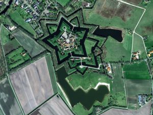
These two images feature Fort Bourtange. They showcase the beautiful, symmetrical star shape of the fortress that was so effective at keeping those within the village safe from attacking forces. Image one is a 50-cm photo was captured by Pléiades 1B on July 23, 2018. The second is a 30-cm image captured by Pléiades Neo on April 19, 2023. These images have custom processing and color balancing applied by Apollo Mapping. PLEIADES © CNES 2023, Distribution Airbus DS.
About the Point of Interest: Fort Bourtange, nestled in the picturesque countryside of Netherlands, is a captivating historical gem. Constructed in 1593 during the Eighty Years’ War, this star-shaped fortress served as a defensive bulwark against Spanish forces. Today, it stands as a beautifully preserved living museum, offering a fascinating glimpse into the past.
Fun Factoids: (1) Fort Bourtange blocked the sole road through an area that was once exclusively marshland. As the fort was expanded, water from the marsh was channeled into moats and used for farming irrigation. (2) The town houses a traditional windmill and wooden structures hanging over the moat that were used as toilets. (3) The five-sided shape of the fort, a design that originated in Italy, was constructed to give those inside the fort a panoramic view of oncoming attackers as well as an opportunity to attack forces from the front and their flanks. (4) The historical museum within the fort contains a 19th Century synagogue that was a place of worship for local Jews before Adolf Hitler’s invasion. (5) One of the most famous battles that occurred at Fort Boutange was that of the 1672 invasion by the German Bishop of Münster. Thanks to the marshes surrounding the Fort, the invading army was successfully deterred.
The 50-cm Pléiades 1 High-Resolution Satellite Constellation
The Pléiades 1 constellation (or at least part of it!) has been in orbit since December 2011 and if you have not had a chance to check out any sample imagery, take a few moments and have a look at the gallery on our website. If you work with high-resolution imagery, you should consider Pléiades 1 and Pléiades Neo for your next geospatial projects.
A variety of Pléiades 1 products are available from both a well-established archive and as a new collection, including 50-centimeter (cm) pansharpened imagery and 50-cm panchromatic–2-meter (m) 4-band multispectral bundles. We are happy to discuss the technical specifications, pricing and tasking options available with both of these satellite constellations.
The 30-cm Pléiades Neo High-Resolution Satellite Constellation
Pléiades Neo is our newest high-resolution satellite constellation. The first Neo satellite went up in April 2021 and the second in August of the same year. This 30-centimeter resolution constellation will add two more satellites in the next few months and upgrade from daily to intraday revisits. Pléiades Neo has six multispectral bands with 1.2-meter resolution, including a deep blue and two infrared bands, along with a 30-centimeter resolution panchromatic band.
The archive is growing every day, and the satellites are available for new collections, making Pléiades Neo the perfect solution for site monitoring. Check out our beautiful sample images in the Pléiades Neo gallery.
More sample images and technical information about Pléiades 1 can be found on our website here; while the same can be found here for the Pléiades Neo constellation.
The Apollo Mapping sales team can answer any questions you might have about Pléiades 1 and/or Pléiades Neo. We can be reached at (303) 993-3863 or sales@apollomapping.com.
 This map shows the areas imaged by the Pléiades 1 constellation from July 1 to September 30, 2023 over the Middle East. Please note that in many instances, multiple images were collected over the same area which is difficult to portray on this static map.
In this monthly piece, we give our readers a sense of the high-resolution imagery coverage collected over a geography during a specified window. To do this, we pick a high-resolution satellite constellation, a defined time period and area of interest, then report key statistics on the total amount of imagery collected in square kilometers (sq km). Without further delay, let’s jump into our analysis.
Graphic Region of Interest: Middle East
Land Mass Covered: 6,674,329.3 sq km
Time Period: July 1 to September 30, 2023
High-Resolution Satellite Constellation: Pléiades 1A/1B
Pléiades 1 Constellation Imaging Statistics–Middle East
Total Area Collected: 2,967,487.8 sq km; 16,127.7 sq km per satellite/per day
Area Collected @ 20% or Less Clouds & 30 Degrees or Less Off-Nadir: 2,528,258.6 sq km; 13,740.5 sq km per satellite/per day; 85.2% of total (WOW!!)
- Welcome to this month’s collection of nerdy updates! Browse through the links below to check out what’s going on with Lithium-ion batteries, computer memory, the Sun, and more:
Research shows path to reduced-cost lithium-ion batteries with manganese.
More efficient process for converting carbon dioxide into usable chemicals.
New stable form of gold has promise for solar cells and more.
This system captures up to 40% of the Sun’s energy to make green hydrogen.
3D-printed materials could improve future fusion plants.
Soil can be decontaminated using carbon compounds and electric pulses.
Graphene shows promise for improved computer memory and hard drives.
 The NOAA extreme weather map shows that the Arctic Sea ice extent ranked seventh lowest on record, while the Antarctic hit a record low for the sixth consecutive month. The region of Ghana was hit by severe flooding, forcing the evacuation of over 26,000 people. There were also some major storms in October, including Hurricane Otis and Cyclone Lola. (Image Credit: NOAA Global Climate Report)
- The October 2023 NOAA Global Climate Report has been released and the alarming trends continue. October 2023 joins September 2023, having an average global surface temperature that ranked highest for the month since record collecting began in 1850! This is nothing to take lightly folks. North and South America experienced higher than average temperatures in October; as did western, eastern, and southern Europe, Africa, Asia, Oceania, and the Arctic. Italy, Spain, Peru, Bolivia, and many other countries had their warmest October ever. The sea surface temperatures in the northern, western, and eastern Pacific, as well as, the northern Atlantic and Indian oceans were above average. 11% of the World’s surface experienced record-warm temperatures in October, which is the highest percentage in October since 1951.
- December 1 is World’s AIDS Day. In honor of this, our Google search was, “AIDS and GIS”. We came across a MEASURE evaluation fact sheet, featured on measureevaluation.org dedicated to the treatment and intervention of AIDS/HIV. The article goes into great detail about how new MEASURE evaluation techniques are being implemented, using GIS map data such as those from the World Health Organization to show the location of facilities and the types of treatment offered. Check it out here.
- We took a look at the online GIS resources for Rochester, NY last month. This month we’re making our way to Grand Forks, North Dakota’s third-largest city. We found an easy-to-navigate, resource-filled GIS website linked below for you to check out. We were however unable to locate a way to bulk download GIS data directly.
Grand Folks, ND GIS Website
Grand Folks, ND GIS Contacts
Grand Folks, ND GIS Web App
Grand Folks, ND GIS Map Collections–also located on front page of GIS website
Grand Folks, ND GIS Direct Downloads–no direct downloads but there are individual map/app downloads on the GIS homepage at the bottom
Brock Adam McCarty
Map Wizard
(720) 470-7988
brock@apollomapping.com

A 15-cm color samples of Hexagon imagery collected over St. Augustine, Florida during late 2022 to early 2023.
This month, Hexagon released new 15-centimeter resolution imagery of Florida and South Carolina. You can also access 30-cm stereo and DSM data with unrivaled accuracy. They’re keeping up with their imagery updates in the US with Georgia and Mississippi up next.
Reach out to us at sales@apollomapping.com to learn more. Hexagon imagery can be queried at anytime on Image Hunter as well!
In this monthly feature, we span the globe to examine Our Changing Landscape with a time series of medium-resolution PlanetScope satellite imagery. The PlanetScope constellation dates back to 2016 and collects hundreds of millions of square kilometers of four and eight-band 3-meter imagery daily! In November, we looked at the devastating wildfires that swept the Lahaina area of Maui, Hawaii. This month, we’re traveling to Derna, Libya to examine the tragic flooding that recently inundated the area.
The PlanetScope Microsat Constellation

Click on the image above to see an animation of 3-meter natural color PlanetScope imagery collected over Derna, Libya on August 31 and September 15, 2023. In the history of this series, we have covered multiple floods but none of them have displayed the intensity of mother nature as this animation of the September 11th dam breached and subsequent flooding shows. In the September 15th image you can see how intense the flood waters must have been as they gouged out deep channels in the canyons to the south of Derna. And then within Derna, you can see that a wide swath of the center of town was literally wiped out as the flood waters made their way to the ocean. Just tragic–our hearts are with the residents, family and friends of Derna. (Images Courtesy: © Planet 2023)
PlanetScope is a constellation of more than 240 microsats referred to individually as Doves. Each Dove is able to collect up to 20,000 square kilometers (sq km) per day of 3-meter (m) 4-band multispectral (i.e. blue, green, red and near-infrared [NIR]) imagery; and newly launched SuperDoves collect 8-band multispectral adding in valuable red-edge spectral data. Across the constellation, PlanetScope is archiving more than 200 million sq km of medium-resolution imagery a day, making it the go to source for daily imagery over most locations. This massive archive dates back to 2016, offering the most complete and continuous record of spatial data on the planet since the start of the constellation’s ongoing launch schedule. Collecting 3-meter multispectral imagery is the equivalent of ‘high-resolution’ multispectral data imaged by a 75-centimer (cm) satellite (as this satellite would feature 75-cm panchromatic and 3-m multispectral), making PlanetScope an extremely competitively priced option at just $2.25 per sq km. With well registered images and nearly daily collections of most locations, PlanetScope is the ideal imagery source for this current-events focused series, Our Changing Landscape.
September 2023 Derna, Libya Flooding
On September 10th and 11th of this year, the coastal city of Derna, Libya faced a harrowing natural disaster as torrential rains triggered severe flooding, leaving a trail of devastation in its wake. Derna, situated along the Mediterranean coast, typically enjoys a moderate climate, and the unexpected deluge was a stark departure from its usual weather patterns.
The flooding was caused by Mediterranean Storm Daniel which passed through Libya and dropped the equivalent of eight months-worth of rain in one weekend, destroying nearly 25% of Derna. The destruction was caused by massive amounts of mud and water released with the collapse of two dams upstream (from the pressure of Daniel’s precipitation)–with the actual collapses happening in the early hours of September 11th.
Climate scientists and meteorologists point to the changing climate, which has led to increased sea temperatures in the Mediterranean, as a key factor in the flooding. Warmer waters can fuel more intense rainfall; and in this case, it resulted in the heavy downpours that caused such widespread flooding.
The consequences for Derna and its citizens were devastating. Streets turned into rivers, homes were inundated, and livelihoods were disrupted. Tragically, over 4,000 lives were lost and more than 10,000 people were missing after the heavy rains. According to counts given by the International Organization for Migration, nearly 40,000 people were displaced by the storm, three quarters of which were displaced specifically from Derna. The community has faced significant economic and emotional hardships in the aftermath of the flooding.
The September 2023 flooding in Derna underscores the urgent need for communities to increase their preparedness and resilience in the face of Climate Change and the unpredictable weather events it spurs. As communities worldwide grapple with the realities of a changing climate, events like the flooding in Derna highlight the critical imperative of both adaptation and mitigation strategies to protect lives and livelihoods in an increasingly uncertain environmental landscape. It is incumbent upon the global community to take swift and decisive action to mitigate these impacts and protect the most vulnerable among us.
If you would like to contribute financially to the restoration efforts in Derna, donations may be made here.
If you would like to find out more about using 3-meter PlanetScope imagery for your academic studies, engineering projects or any landscape analysis, let us know at sales@apollomapping.com or (303) 993-3863.