
In February, we looked at Franciacorta Karting Track in Italy. This month for the Pléiades 1–Pléiades Neo Point of Interest, we check out Chateau Chenonceau in Chenonceaux, France.

 These two satellite images show how far the castle spans as well as its elaborate gardens with walking paths. The bridge that crosses over the river Cher can be seen here too. Image one is a 50-cm photo captured by Pléiades 1B on August 8, 2023. The second image is a 30-cm image captured by Pléiades Neo 3 on June 25, 2023. These images have custom processing and color balancing applied by Apollo Mapping. PLEIADES © CNES 2024, Distribution Airbus DS.
About the Point of Interest: The Château de Chenonceau is a French château stretching across the river Cher near the small village of Chenonceaux, Indre-et-Loire, Centre-Val de Loire. The village sits in the Touraine-Chenonceaux wine-growing area and is bordered on its northern edge by the Forest of Amboise. It is one of the best-known châteaux of the Loire Valley, which is a valley located in the middle stretch of the Loire river in central France. The estate of Chenonceau was first mentioned in writing in the 11th Century. The original château was set on fire in 1412 to punish the owner, Jean Marques, for an act of sedition. He rebuilt the château and added a fortified mill on the site in the 1430s. The current château was built between 1514 and 1522 on the foundations of an old mill and was later extended to span the river. The bridge over the river was built between 1556 and 1559 according to designs by the French Renaissance architect, Philibert de l’Orme. The gallery on the bridge, built between 1570 and 1576, followed designs from Jean Bullant.
Fun Factoids: 1) During the Great War, Chenonceau was converted into a military hospital. 2) During World War II, the great gallery of Chenonceau became the only access to the free zone. 3) It also became a clandestine passage for people fleeing the Nazis. 4) U.S. President Harry Truman toured the castle for his first visit to France. 5) The castle has been open to visitors since 1913. 6) After King Henry II died in 1559, his strong-willed widow and regent Catherine de’ Medici forced his mistress Diane de Poitiers to exchange it for the Château Chaumont. Queen Catherine then made Chenonceau her own favorite residence, adding a new series of gardens.
The 50-cm Pléiades 1 High-Resolution Satellite Constellation
The Pléiades 1 constellation (or at least part of it!) has been in orbit since December 2011 and if you have not had a chance to check out any sample imagery, take a few moments and have a look at the gallery on our website. If you work with high-resolution imagery, you should consider Pléiades 1 and Pléiades Neo for your next geospatial projects.
A variety of Pléiades 1 products are available from both a well-established archive and as a new collection, including 50-centimeter (cm) pansharpened imagery and 50-cm panchromatic–2-meter (m) 4-band multispectral bundles. We are happy to discuss the technical specifications, pricing and tasking options available with both of these satellite constellations.
\
The 30-cm Pléiades Neo High-Resolution Satellite Constellation
Pléiades Neo is our newest high-resolution satellite constellation. The first Neo satellite went up in April 2021 and the second in August of the same year. This 30-centimeter resolution constellation will add two more satellites in the next few months and upgrade from daily to intraday revisits. Pléiades Neo has six multispectral bands with 1.2-meter resolution, including a deep blue and two infrared bands, along with a 30-centimeter resolution panchromatic band.
The archive is growing every day, and the satellites are available for new collections, making Pléiades Neo the perfect solution for site monitoring. Check out our beautiful sample images in the Pléiades Neo gallery.
More sample images and technical information about Pléiades 1 can be found on our website here; while the same can be found here for the Pléiades Neo constellation.
The Apollo Mapping sales team can answer any questions you might have about Pléiades 1 and/or Pléiades Neo. We can be reached at (303) 993-3863 or sales@apollomapping.com.
- Are you ready for your monthly dose of amazing technological advancements? I hope so as here we go!
Oak Ridge National Laboratory 3D prints metal wind turbines.
New lithium battery holds 80% of its charge after 6,000 cycles and charges in 10 minutes.
New sustainable method to clean water.
Method to remove carbon dioxide from the air at room temperature.
Yep, now we even have dirt-powered fuel cells!
These light-powered yeast could revolutionize biofuel production.
Human-made leaves generate power from the Sun and wind.
Low-cost organic cathode developed to replace expensive cobalt options.
Catalyst to support hydrogen gas production developed without precious metals.
This material could make computer processing and memory possible in one location.
New battery charges in just five minutes.
This system can desalinate water as well as store energy.
While this one can create in-demand chemicals from carbon dioxide.
Driving 600 miles on this next-generation lithium-silicon battery is possible.
 The NOAA Selected Significant Anomalies map for January 2024 shows that while Antarctica had its 5th coldest winter on record, it also had the 5th lowest sea ice extent; while the Arctic had it 15th warmest, it had its 20th lowest sea ice extent. Africa and South America recorded their warmest January’s while Europe had its 19th warmest on record. For the 10th month in a row, global ocean temperatures hit a record high. (Image Credit: NOAA Global Climate Report)
- The NOAA Global Climate Report for January 2024 has been released and it is further proof that global warming remains a concern. Temperatures were above average across much of the globe, but the eastern United States, most of Europe and a few other areas were surprisingly cooler than average. While the Northern Hemisphere’s snow cover was near average, the Antarctic Sea ice extent was fifth lowest on record for January. Global precipitation was at near record-high levels in January, following on the heels of a record-setting wet December. There is a 22% chance that 2024 will be the warmest year in NOAA’s 175-year record and a 79% chance that El Niño will transition to neutral conditions by mid-year.
- When March rolls around, thoughts gravitate toward St. Patrick’s Day. If you don’t wear green, you might get pinched while searching for that pot of gold at the end of a rainbow. Just in time for this lucky holiday, our Google search of the month was, “GIS and St. Patrick’s Day.” We discovered that lots of communities use GIS to map out their community’s St. Patrick’s Day parade route as well as any foot races and run fests planned for the holiday. There’s also a digital map of some of the best parades, festivals and events happening across Ireland for St. Patrick’s Day. We found an interactive map developed from a study done in 2009 by Drs. Kenneth Field and Linda Beale that looked at the use of GIS to create a, “visual interpretation of the spatial and quantitative distribution of birth data from the 1890 Irish census of population.” The birth data identifies the surname of every child born by county. The surnames on the map have either historic or numeric importance to the counties of Ireland and as such the map provides an illustration of the associated geographies. The resulting “Geo-Genealogy of Irish Surnames” is a densely typeset map with label symbol scaling of Irish surnames proportional to the number of births recorded in the 1980 census. A PDF of the Irish Surnames map (36 MB in size) is also available.
- We took a look at the online GIS resources for Norman, OK, last month. This month, we’re heading over to Eugene, OR, a college town nestled within the famous Willamette Valley along the Willamette River. Situated a mere hour and 15 minutes from the Oregon Coast, Eugene boasts wineries, many great Olympic runners, the roots of Nike and countless track and field events. We found an easy-to-navigate, resource-filled GIS website linked below for you to check out.
Eugene, OR, GIS Website
Eugene, OR, GIS Contacts–just a contact form, sorry!
Eugene, OR, GIS Web App
Eugene, OR, GIS Map Collections
Eugene, OR, GIS Direct Downloads–scroll to mid-page, City Data section
Brock Adam McCarty
Map Wizard
(720) 470-7988
brock@apollomapping.com
Last month, we looked deeper into Japan’s SLIM spacecraft moon-landing adventures. This time, we’re getting to know NASA’s twin tiny satellites launching into space this spring. The goal of the shoebox-sized cube satellites is to unravel the mystery of heat loss from Earth’s polar regions for the first time, resulting in more accurate climate models.
In May, PREFIRE, short for Polar Radiant Energy in the Far-InfraRed Experiment, will launch two cube satellites, also known as CubeSats, into Earth’s atmosphere. The mission will provide new data on various climate variables, such as surface properties, atmospheric temperature, clouds, and water vapor. PREFIRE is a collaboration between NASA, the University of Wisconsin-Madison, and team members from the Universities of Michigan and Colorado.
 Two CubeSats for the PREFIRE Mission will measure how much heat is absorbed and emitted from the Earth’s polar regions. (Credit: NASA/JPL-Caltech)
The CubeSats will launch two weeks apart and will be equipped with a thermal infrared spectrometer. The equipment was designed by NASA’s Jet Propulsion Laboratory and includes mirrors of a specific shape with detectors meant to split and measure infrared light. This is similar to the technology used by the Mars Climate Sounder on NASA’s Mars Reconnaissance Orbiter. The PREFIRE engineering team developed a scaled-down version that weighs less than 6 pounds and captures readings using a thermocouple.
To ensure the maximum amount of coverage, the satellites will zoom along Earth’s orbit on different paths, and the paths will overlap every few hours near the North and South poles. The Earth’s polar regions are extremely important to balance incoming and outgoing energy. The difference between the two energies determines our planet’s temperature and helps to influence our climate. Brian Dourin, scientist and deputy principal investigator for PREFIRE, says the mission will help close the gap and help scientists develop more accurate climate models.
He stated that PREFIRE has the, “potential to discover some fundamental things about how our planet works.” Dourin also explained that our knowledge of how efficiently radiation is emitted into space through the North and South Poles is incomplete. The importance of that radiation hasn’t been at the forefront until now and PREFIRE plans to measure it.
Tristan L’Ecuyer, professor at the University of Wisconsin-Madison and the mission’s principal investigator, explained changing the polar regions would fundamentally change the weather around the world. Climate models help scientists project and understand these changes, and the PREFIRE mission will give scientists new data that will help improve the accuracy of these climate models.
The mission is sure to gather vast amounts of important data that will help NASA and other scientists understand the world in a much deeper way.
Did you see the news that we have a satellite constellation in Image Hunter that offers high-resolution mono, video and nighttime imagery? If not, read on and find out more about this exciting constellation!
CG continues to invest in their 75-cm resolution satellite constellation, and we are happy to announce that we added seven more 75-cm Jilin-1 satellites to Image Hunter in January 2024! All are a part of their GF03D series with 75-cm resolution panchromatic bands and 3-meter resolution multispectral bands. The satellites have been in operation since May 22, 2023, and their addition boosts our archive of 75-cm resolution imagery. As the Jilin-1 constellation grows we are adding more content to Image Hunter, creating an ever-expanding high-resolution archive.
 This 75-cm color Jilin-1 image was collected by the GF02 series over Dubai, UAE on October 31, 2021. (Images Courtesy: CG)
Apollo Mapping offers high-resolution Jilin-1 imagery from satellites owned and operated by CG. This partnership unlocks a constellation of multiple satellites launched between 2015 and now. With a robust archive accessible through Image Hunter, the Jilin-1 product suite includes nighttime, video and mono imagery!
Jilin-1 offers an impressive variety of resolutions from 30-cm to 1.2-m. It’s also the only constellation boasting an array of unique capabilities, like 120-second color video collected at 92-cm and 1.2-m resolution; and 92-cm to 1.2-m color nighttime imagery. Five satellites in the Jilin-1 Video series also collect a 3.68-meter red-edge band for vegetation mapping; while satellites in the KF series collect data with a massive 136-kilometer (km) wide footprint or greater. With so many satellites in orbit, Jilin-1 revisits the same location up to six times a day, resulting in a robust archive filled with large-footprint images.
Check out some of the interesting specifications that set the Jilin-1 constellation apart from its competitors:
- Sensor Resolution: (at nadir)
- Optical A–72-cm panchromatic, 2.88-m multispectral
- Video 01/02–1.13-m color (video imaging only)
- Video 03–92-cm color (video & nighttime imaging only)
- Video 04/05/06/07/08–92-cm panchromatic, 3.68-m multispectral; 92-cm color (video & nighttime imaging only)
- GF03C-01/02/03–1.2-m color (video & nighttime imaging only)
- GF02A/GF02B/GF02C/GF02D/KF01A/GF03D/GF03D Series–75-cm panchromatic, 3-m multispectral
- KF01B/KF01C–50-cm panchromatic, 2-m multispectral
- GF03B-01/02/03/04/05/06–1-m panchromatic, 4-m multispectral
- GF03A–1.06-m panchromatic, 4.24-m multispectral
- GF04A–30-cm panchromatic, 1.2-m multispectral
- Collection Geometry: (at nadir)
- Optical A: 11.6 km (width) x 11.6 km (length)
- Video 01/02: 4.6 km × 3.4 km
- Video 03: 11 km x 4.5 km
- Video 04/05/06/07/08: 19 km wide x up to 420 km long (pushbroom, daytime imaging); 11 km × 4.5 km (video & nighttime imaging only)
- GF02A/B: two cameras at slightly over 20 km, combined footprint width of 40 to 42 km; 2,100 km maximum length
- GF03A: 18.5 km x up to 2,280 km
- KF01A: 136 km x up to 4,200 km; full scene is divided into 23 km x 23 km sections upon data transfer
- GF02D/F: 40 km wide
- GF03C-01/02/03: 14.4 km (wide) x 6 km (long)
- GF03B-01/02/03/04/05/06, GF03D Series: > 17 km wide
- KF01B/KF01C: > 150 km wide
- GF04A: 15 km wide
You can search for Jilin-1 coverage 24-hours a day by using Image Hunter.
And you can request a new price list with 30-cm Jilin-1 added in by emailing us at sales@apollomapping.com!
I may have said this before, but typically, I write the title first and then a few days or weeks later, I write the article. The reason for doing this is so I think a little bit about the topic before I write. Sometimes I’ll have forgotten what my original intentions were. And sometimes they’ll just change. That’s kind of the case here, but I’m sticking with the title, and it is about New Orleans (NOLA) indirectly, but it’s really about relationships. But I don’t need to tell you that if you continue reading, as you’d likely figure it out on your own…
But this part of the saga does take place in New Orleans in part (but really, its origins began long before this trip). I met her (it always comes back to women for me, somehow) at a conference for the first time, I think in it was February 2017 in Indianapolis. Our interactions were minimal but enjoyable, that year and the two that followed (the conference takes place every February), but we’d apparently had some chemistry or sparks, at least on her end, enough for her to be curious. Come 2020, and just before the pandemic settled over the world, we had more substantive exchanges throughout that year’s rendition, and I followed up with her afterwards to see if she wanted to collaborate on something. Pure and innocent intentions, I swear.
But as these things go sometimes, we sparked up an electronic pen-pal relationship that was, at times, all-consuming. She was three hours from me, and I maintain for at least the first month, I didn’t expect much beyond those exchanges, even though I enjoyed them and looked forward to them every day very much. We told one another everything. We sent at least 1,000 emails over the course of roughly two months. She told me about her broken marriage and how she was thinking about leaving him but didn’t want to hurt her daughter. Then he found out about our little exchanges, and our little situation exploded. This led to her coming to visit me a few times, and an existential crisis developed for her about the path forward–and without taking too many detours or spilling all my guts on it, she ended up staying with her husband for the sake of her daughter, and we maintained contact, but in different ways, and far less frequently. Sometimes she stayed in mind, more often she didn’t. But she was never too far in my mind, and certainly easily summoned in thought…
 Through all the crowds and debauchery, you can still find love in the Big Easy. (Photo retrieved here and comes courtesy of Kendall Hoopes.)
The conference was online in 2021 and 2022, so there were no opportunities to see one another in real time and space. We maintained sporadic contact, but she was–and is–heavily watched by her husband. Based on some of the things she tells me, their relationship is much better now, but other things I infer, I’m not so sure. So, in 2023, when we were back in person at the conference, I was eager to see her. As with this year, it was also in NOLA. I first met up with some old buddies that first night on the ground and had several drinks (refer back to a column on this topic from last year), and then met up with her. We had loving but innocent interactions over the span of 2.5 days; it had an air of puppy love about it. But then the conference was over, and I knew I wouldn’t see her again for a while.
So, we started sending each other cards–I had to send them to her work so that her husband wouldn’t be suspicious. In them, we talked about everything, from the everyday mundane things to our dreams and feelings for one another. Those lasted for about 3-4 months until I headed west for two months for the summer and wouldn’t be at a fixed address, so the correspondence stopped. Upon my return, we fell into the post-crisis sporadic exchanges, though, those turned more frequent as I joined the conference planning committee and we had to engage together a lot more. Many others were also involved, so these weren’t one-on-one sessions, but occasionally, we’d innocently fall into a back-and-forth email exchange between just us. And this past week, back in NOLA, it was just like last year: innocent puppy love, and only brief opportunities to be “alone” together, but those instances were mostly within eyeshot of our colleagues, so still muted, unfortunately. As we walked down Bourbon Street on the last night I would see her for another year, probably, we dropped to the back of the pack, holding hands and clumsily fawning over one another. When we all dispersed, the hug wasn’t as affectionate as either of us would’ve liked. We closed the night out in our separate rooms with a few short, but sweet and loving texts, and now today (I am writing this after my flight back), we will go back into hibernation…
The weekend that follows, which will happen after this writing, sees an old girlfriend coming to visit me, someone who I dated briefly, but intensely, eight years ago. We’ve stayed in close contact, though, with a few tristes several summers back, but she’d fallen into a long-term relationship and so she and I just improved our platonic friendship. Though, I remained fairly open about the fact that I also still loved her, but that we were just in different stages of life–and different places: me on the east coast, she on the west coast. But a year ago, that long-term relationship finally gave out, and over the course of the year that followed, she put her pieces back together, sowed her oats or rebounded or whatever she needed to do, and then she said she wanted to come visit. And we made plans for that to happen, and it is. The weekend after I was in NOLA, stumbling through another lost love situation.
This weekend will be much different, though, for many different reasons. I expect we’ll have a lot of fun; I wonder what the sparks and feelings will be like. But I also worry that it won’t be what it once was and that we will be doing damage to what has become a very good friendship. I also think I’m okay gambling on that, but it’s not like I expect it to be anything more than a weekend of fun and companionship. Though, I do also wonder if it will just leave me with the feeling of another girl that will never be in my life the way I’d once thought she would be, or at least hoped she might be. I wouldn’t say I have a lot of heartache over the girls I’ve dated per se, but there are a handful who I often think about if things had been different, could we have gone the distance together? It’s really these two and maybe a couple others, but it could just be nostalgia. It could be simply that I like the idea of what could have been more than I’d like the real thing had it actually been. I likely will never know. I may also like keeping people at a distance, crafting my own narrative of loss and love, as I become more and more of a loner and curmudgeon…
I went out with another female friend the other day, before the NOLA trip, one who I’d met through a dating app–that didn’t work out, obviously, but we’ve become fairly good friends. One of the reasons she said it didn’t work out for us in that way is because I remind her of the worst qualities of her two brothers combined. It’s funny, possibly true, but also has a tinge of sadness to it. But anyway, she’s also had her relationship struggles and pains, and she asked me if I thought she’d always be alone. I said “no,” but I could see that didn’t convince her. I’m far more okay with being alone than she is, but I admitted to her that whenever I see an older man eating by himself at a restaurant, it makes me feel sad, and reminds me that I don’t want to end up like that. But the years keep ticking, and the good times keep rolling, only sometimes, I don’t know where they rolled to…
Marco Esquandoles
“I’ve known a lot of women, but she never escaped my mind.”
– Tangled Up In Blue, Bob Dylan
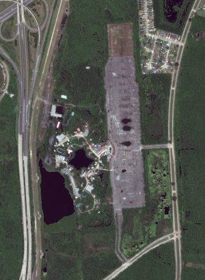 This month’s 30-cm WorldView-3 image features Jazzland–Six Flags in New Orleans, Louisiana. While Jazzland opened in 2000, Six Flags took over just three years later in 2002 changing the name to Six Flag New Orleans. But after Hurricane Katrina inflicted damage on the area, not all of the floodwaters receded and what was left caused saltwater damage to the rides and buildings. Eerie, like the set of a scary movie, best describes this image of the abandoned Six Flags New Orleans. The largest rollercoaster winds in and out of the overgrown patch of trees, while the smallest rollercoaster can barely be seen above the tops of the trees. The buildings are run down, resembling an abandoned ghost town. A body of goopy water left over from Hurricane Katrina drowns out many areas of the park and the Ferris wheel nearby appears to be leaning after enduring the high winds of a hurricane. Even the parking lot has the distinct feel of being long neglected with its dark patches, cracks and other signs of wear and tear. New Orleans Police have battled vandalism and graffiti at the abandoned amusement park, but numerous movies have filmed at the creepy property including Killer Joe, Stolen, Percy Jackson: Sea of Monster, Dawn of the Planet of the Apes and Jurassic World. A rapper even used parts of the park in a music video. The 30-cm WorldView-3 image of Six Flags New Orleans was captured April 21, 2021. This 30-cm WorldView-3 image has been processed by Apollo Mapping for improved perspective, clarity and colors. (Satellite Imagery © 2024 Maxar Technologies)
Every time we look at WorldView-3 and WorldView-4 (WV3/4) imagery, we are blown away. And we hope you are equally impressed with the data! In February, we checked out a football (soccer) field surrounded by historic buildings in Imotski, Croatia. For this edition of the 30-cm Color WorldView-3/4 Image of the Month, we gaze in disbelief at the abandoned Six Flags amusement park in New Orleans.
WorldView-3 launched in late 2014 and WorldView-4 launched in late 2016; taken together they are the most advanced satellite constellation the commercial marketplace has ever had access to. Here are a few of the features that really set these satellites apart from the competition:
- Improved Resolution
- Higher resolution means you can see more detail in WV3/4 imagery.
- Data collected at nadir will have 31-centimeter (cm) panchromatic, 1.24-meter (m) visible and near infrared, 3.7-m SWIR (WV3 only) and 30-m CAVIS (WV3 only) bands.
- At 20 degrees off-nadir, the resolution is 34-cm panchromatic, 1.38-m visible and near infrared and 4.1-m shortwave infrared.
- Additional Spectral Bands
- If spectral analysis is part of your project, then no other satellite can match WV3 with its: 8 bands of visible and near-infrared data; and 8 shortwave infrared bands which are crucial for geological studies.
- Better Positional Accuracy
- With accuracies of 3.5-m CE90% or better (without ground control even!), WV3/4 has no rivals for its enhanced positional accuracy.
- Daily Revisits
- At 40 degrees latitude, WV3 is able to image every location daily with 1-meter or better resolution and then every 4.5 days at 34-cm resolution or better.
- WV4 is no longer collecting new imagery.
- At 40 degrees latitude, WV3 is able to image every location daily with 1-meter or better resolution and then every 4.5 days at 34-cm resolution or better.
- Increased Collection Capacity
- WV3/4 feature 13.1-km swath widths (at nadir) with the ability to collect up to 680,000 square kilometer (sq km) of high-resolution data per day per satellite (though WV4 is dead now).
- Improved control movement gyros translate into larger maximum contiguous collection areas per pass, with up to ~7,500 sq km of mono imagery and ~3,000 sq km of stereo possible.
If you are interested in WorldView-3 and/or WorldView-4 imagery for your next project, please let us know by phone, 303-993-3863, or by email, sales@apollomapping.com.
You can also find more WV3 samples and technical information on our website here and then WV4 samples and information can be found here.
 This map shows the areas imaged by the WorldView-2/3 constellation from February 1 to April 30, 2023 over Central America. Please note that in many instances, multiple images were collected over the same area which is difficult to portray on this static map.
In this monthly piece, we give our readers a sense of the high-resolution imagery coverage collected over a geography during a specified window. To do this, we pick a high-resolution satellite constellation, a defined time period and area of interest, then report key statistics on the total amount of imagery collected in square kilometers (sq km). Without further delay, let’s jump into our analysis.
Graphic Region of Interest: Central America (plus small islands)
Land Mass Covered: 2,468,332.1 sq km
Time Period: February 1 to April 30, 2023
High-Resolution Satellite Constellation: WorldView-2/3
Pléiades 1 Constellation Imaging Statistics–Central America
Total Area Collected: 2,244,389.8 sq km; 12,608.9 sq km per satellite/per day
Area Collected @ 20% or Less Clouds & 30 Degrees or Less Off-Nadir: 918,051.2 sq km; 12,608.9 sq km per satellite/per day; 40.9% of total

Cricket’s Chirp is created for Apollo Mapping by Ron Ruelle, a Wilmington, NC (formerly Boulder, CO) based cartoonist, lllustrator and teacher. No animals are harmed in the creation of these comics, but Ron sometimes breaks a pencil in frustration. You can see more of his work at www.ronruelle.com