
If you are searching for medium and high-resolution satellite imagery, the search is over as Image Hunter is the solution you’ve been looking for! Featuring satellite and aerial imagery as well as digital elevation models (DEMs) from a constantly expanding list of 60+ constellations/datasets and 19 vendors, our database contains more than 200-million images/records meaning there is just no other website out there with this breadth of commercial data products. Our interface is slim-lined and modern, loading quickly on all platforms, browsers and operating systems. Further, our database is updated multiple times an hour with the most recent images collected by WorldView-3, Pléiades 1, PlanetScope, SuperView-1 and many more so you are sure to get the most current view of all the imagery and DEM databases we work with. Once you submit your request, an Apollo Mapping representative will be in touch within 4 Colorado business hours to get you the pricing information you need for your project.
So why wait? Give Image Hunter a try now to find the imagery and/or DEM data you need for your next mapping project!

Key Improvement(s) From The Past Month
Yep, it’s true, even in December amidst the Holiday season, Apollo Mapping is busy working to improve Image Hunter and make your browsing experience better! And again this month the focus has been on our shrinking backlog of open bugs; so let’s jump right into the list of improvements for the month.
Here is a summary of the changes/improvements we made to Image Hunter during the past month:
- Fixed the formatting of a few modals.
- Added UTC collection time for 1-m KazEOSat-1 imagery.
- Implemented a loader symbol for large datasets.
- Improved the backend handling of persistent links.
Data Alert–An Automated Daily Imagery Search
Have you checked out Data Alert which lets you define an area of interest anywhere around the globe, the resolution your project requires and the number of months we should keep the alert active? Once an alert is set up, we check for new data over your area of interest every single day, and send you an email when we find coverage that meets your specifications. We have a short YouTube video with directions to set up a Data Alert, check out the last video; and we have written directions for Data Alert here.
The Sensors Available in Image Hunter
As you might have seen in past articles, we now feature hourly updates (seriously!) of GaoFen 1/2, GeoEye-1, KOMPSAT 2/3/3A, Pléiades 1 and Neo, SPOT 6/7, SuperView-1, TripleSAT, WorldView-1/2/3/Legion and ZiYuan-3!
Image Hunter can be accessed 24 hours a day, 7 days a week and is a one-stop shop for every major source of medium and high-resolution satellite (and aerial!) imagery on the market today, including:
- WorldView Legion
- WorldView-4
- WorldView-3
- WorldView-2
- WorldView-1
- QuickBird
- GeoEye-1
- IKONOS
- EROS B
- KOMPSAT-3A
- KOMPSAT-3
- KOMPSAT-2
- Pléiades 1 constellation
- Pléiades Neo constellation
- TerraSAR-X (TerraSAR-X, TanDEM-X and PAZ)
- GEOSAT-1
- GEOSAT-2
- TripleSat
- BJ3A
- BJ3N
- SPOT 1 to 7 constellation
- RapidEye
- GaoFen-2
- GaoFen-1
- ZiYuan-3 01/02 (mono and stereo!)
- FORMOSAT-5
- FORMOSAT-2
- ALOS PRISM (stereo)
- AW3D Standard (DEM)
- SkySat constellation
- PlanetScope constellation (including 5-band SuperDove data)
- SuperView-1 constellation
- SuperView-2
- SuperView NEO-1 01/02
- Landsat 1-8
- TeLEOS-1
- Hexagon (HxGN Content Program aerial imagery) imagery + DEM
- WorldDEM
- WorldDEM Neo
- Vricon DEMs
- Orbita Hyperspectral Satellite (OHS)
- KazEOSat-1
- KazEOSat-2
- Jilin-1 Optical
- Jilin-1 Video (including nighttime imagery)
- Jilin-1 GF/DP
- Jillin-1 KF
- Orbita Video Satellites-1/2/3 (OVS-1/2/3)
- BlackSky Global series
Key Features of Image Hunter
If any of our readers have struggled with other geospatial search engines that are clunky, only query one data source and/or do not provide image previews, then Image Hunter is the solution to your woes as it features:
- Online browsing of satellite and aerial imagery from 19 data providers and 56 satellite and aerial imagery derived datasets.
- Near-instantaneous loading of low-resolution preview imagery with collection date, cloud cover and other key metadata.
- The ability to define your area of interest by address, coordinates, geometric shape or shapefile/KMZ.
- A responsive basemap with street names to provide spatial context when discovering data as well as crowd-sourced updates for the most accurate map possible.
- Exports of the area of interest you create as well as the scenes you select in shapefile or KMZ format.
- Support for all operating systems, and not just our friends with Windows machines!
Image Hunter can be accessed here all day and night, we are excited to find out what you think about our imagery search engine! So if you have any ideas and/or feedback to improve Image Hunter, please let us know at sales@apollomapping.com or (303) 993-3863.
 A 15-cm color sample of Hexagon aerial imagery from summer 2024 collected just outside of Logan, Utah.
This month, Hexagon released new 15-centimeter (cm) resolution imagery of Utah, including DSM and stereo data collected during the summer of 2024. They’re keeping up with their imagery updates in the US with California, Wyoming and North Carolina coming soon.
Reach out to us at sales@apollomapping.com to lean more or check out the Hexagon archive anytime online at Image Hunter.
In this monthly feature, we span the globe to examine Our Changing Landscape with a time series of medium-resolution PlanetScope satellite imagery. The PlanetScope constellation dates back to 2016 and collects hundreds of millions of square kilometers of four and eight-band 3-meter imagery daily! In December, we looked at the collapse of the Arba’at Dam and its flooding of Sudan. For the January edition of this series, we are headed to Asheville, North Carolina, where Hurricane Helene caused widespread damage in late September.
The PlanetScope Microsat Constellation
 Click on the image above to see an animation of 3-meter natural color PlanetScope image collected over Asheville, North Carolina on September 22 and October 5, 2024. For those readers based in the USA, I am sure you are aware of the level of destruction our fellow friends in Asheville experienced, it is heart aching. For the rest of our readers, in this before and after Hurricane Helene animation, focus your attention along the river corridor where the destruction was the most drastic and obvious in this 3-m PlanetScope data. (Images Courtesy: © Planet 2025)
PlanetScope is a constellation of more than 240 microsats referred to individually as Doves. Each Dove is able to collect up to 20,000 square kilometers (sq km) per day of 3-meter (m) 4-band multispectral (i.e. blue, green, red and near-infrared [NIR]) imagery; and newly launched SuperDoves collect 8-band multispectral adding in valuable red-edge spectral data. Across the constellation, PlanetScope is archiving more than 200 million sq km of medium-resolution imagery a day, making it the go to source for daily imagery over most locations. This massive archive dates back to 2016, offering the most complete and continuous record of spatial data on the planet since the start of the constellation’s ongoing launch schedule. Collecting 3-meter multispectral imagery is the equivalent of ‘high-resolution’ multispectral data imaged by a 75-centimer (cm) satellite (as this satellite would feature 75-cm panchromatic and 3-m multispectral), making PlanetScope an extremely competitively priced option at just $2.25 per sq km. With well registered images and nearly daily collections of most locations, PlanetScope is the ideal imagery source for this current-events focused series, Our Changing Landscape.
The Wrath of Hurricane Helene on Asheville, North Carolina
Hurricane Helene became the strongest hurricane on record to strike the Big Bend region of Florida, the deadliest Atlantic hurricane since Maria in 2017, and the deadliest to strike the mainland U.S. since Katrina in 2005. As the second major hurricane of the 2024 Atlantic hurricane season, Helene started to form on September 22nd in the western Caribbean Sea. By September 24th, it had become a tropical storm as it approached the Yucatán Peninsula, then became a hurricane early on September 25th. Helene reached Category 4 intensity on the evening of September 26th and made landfall at peak intensity in the Big Bend region of Florida with maximum sustained winds of 140 mph.
Helene moved quickly inland before degenerating to a post-tropical cyclone over Tennessee on September 27th. Helene dumped nearly 14 inches of rain through September 27th on cities along the Blue Ridge Mountains, including Asheville. Widespread flooding led to missing people and pets, houses and entire towns being swept away, thousands left without power and many roads and bridges wiped off the map. North Carolina Gov. Roy Cooper told USA Today that Helene had become, “One of the worst storms in modern history for parts of North Carolina.”
The statewide death toll from Helene in North Carolina now stands at 96, officials told The New York Times. More than 20 people remain missing, as of October 22nd. Ashville remains under a boil-water notice as employees work to clean the North Fork reservoir. Three weeks after the storm, schools and government offices prepared to reopen amid prolonged power outages and water service disruptions. In Asheville, officials lifted a citywide curfew on Monday, and the school district announced classes will resume next week. Major attractions, including the North Carolina Arboretum and the Biltmore Estate, were preparing to reopen. Asheville residents and the city continue with cleanup efforts and rely on a designated processing site for staging, grinding and compacting unwanted debris.
Scientists and researchers believe the increasingly warmer waters of the Gulf spawn these catastrophic storms. According to Brian McNoldy, a climatologist at the University of Miami, the Gulf is currently the hottest it has ever been in the modern record. Recent measurements show the surface temperature nearing 90 degrees Fahrenheit, making a dip in the water feel more like stepping into a bath. “Warmer ocean temperatures cause increased evaporation, transferring more moisture into the atmosphere. This added moisture, coupled with the atmosphere’s greater capacity to hold water vapor as temperatures rise, sets the stage for heavier rainfall when conditions are right. The combination of warm ocean waters and a moisture-rich atmosphere also fuels stronger storms, which can produce more intense and prolonged rainfall,” scientists stated.
If you would like to find out more about using 3-meter PlanetScope imagery for your academic studies, engineering projects or any landscape analysis, let us know at sales@apollomapping.com or (303) 993-3863.
In this monthly article, we travel the world to check out unique, fun and sometimes a bit weird 30-centimeter (cm) color imagery samples from the WorldView constellation. In December, we gazed at ruins in Kayakoy, Turkey. For this edition of the 30-cm Color WorldView Image of the Month, we feature images of Chalet Zermatt Peak in Switzerland.
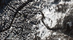 A privately owned luxury ski chalet nestled in the Switzerland village of Zermatt, Chalet Zermatt Peak boasts six floors with five deluxe, double bedrooms, ceiling to floor windows, sky observatory roofing and an indoor/outdoor jacuzzi. There’s also a wraparound balcony overlooking the beauty below and the Matterhorn. Guests who choose to spend time at the tranquil chalet can enjoy an entire floor dedicated to a wellness center with a private gymnasium, spa and in-house massage therapist. There’s also a gourmet chef on staff and a curated wine cellar. The ski chalet was named the “World’s Best Ski Chalet 2023” for the fourth year running by the World’s Ski Awards 2023. So of course, every room is equipped with boot warmers. Each room features a contemporary alpine design with marble from across the border in Italy, traditional wooden beams and natural lighting. In fact, the top room offers a vaulted glass roof for stargazing. The chalet is so private that it can only be accessed by a steep winding footpath leading upward from the village center or by lift access provided by the neighboring hotel. The 30-cm WorldView-3 image featured here was collected on February 12, 2015, and has custom processing and color balance applied by Apollo Mapping. (Satellite Imagery © 2025 Maxar Technologies)
30-cm WorldView-3 (WV3) launched in late 2014, WorldView-4 (WV4) launched in late 2016 and then the first WorldView Legion satellites launched in 2024. Taken together, this is the most advanced satellite constellation the commercial marketplace has ever had access to. Here are a few of the features that really set these satellites apart from the competition:
- Improved Resolution
- Higher resolution means you can see more detail in WorldView imagery.
- Data collected at nadir will have 31-centimeter (cm) panchromatic, 1.24-meter (m) visible and near infrared, 3.7-m SWIR (WV3 only) and 30-m CAVIS (WV3 only) bands.
- Additional Spectral Bands
- If spectral analysis is part of your project, then no other satellite can match WorldView-3 and WorldView Legion with their 8 bands of visible and near-infrared data; and then 8 shortwave infrared bands (WV3 only) which are crucial for geological studies.
- Better Positional Accuracy
- With accuracies of 3.5-m CE90% or better (without ground control even!), the 30-cm WorldView constellation has no rivals for its enhanced positional accuracy.
- Daily Revisits
- With multiple WorldView-3 and WorldView Legion satellites orbiting our planet, daily revisits are available for most locations.
- WV4 is no longer collecting new imagery.
- Increased Collection Capacity
- WV3/4 feature 13.1-km swath widths (at nadir) with the ability to collect up to 680,000 square kilometers (sq km) of high-resolution data per day per satellite (though WV4 is dead now).
- When fully launched, WorldView Legion will feature six 30-cm satellites, significantly boosting the collection capacity of this leading high-resolution constellation.
If you are interested in WorldView-3, WorldView-4 and/or WorldView Legion imagery for your next project, please let us know by phone, 303-993-3863, or by email, sales@apollomapping.com.
You can also find more WV3 samples and technical information on our website here; WV4 samples and information can be found here; and then finally here is more information about WorldView Legion.
NASA’s Juno mission has uncovered jaw-dropping new insights into the fiery volcanic chaos on Jupiter’s moon, Io. Picture this: Io, the most volcanically active body in the solar system, is constantly being torn apart and rebuilt, thanks to Jupiter’s relentless gravitational tug-of-war. During a recent flyby, Juno gathered data that brings us closer than ever to understanding the true scale of Io’s volcanic fury.
This volcanic drama stems from tidal heating–a process where the gravitational dance between Jupiter, Europa, and Ganymede generates so much internal heat that Io practically oozes molten rock. Think lava lakes bubbling like cauldrons, sky-high plumes shooting molten material, and glowing rivers of liquid fire. Juno’s up-close-and-personal observations reveal how these forces mold Io’s ever-changing, volatile surface.
But the story doesn’t stop there. Io’s volcanic processes are more than just a planetary spectacle–they offer scientists clues about volcanic activity across the solar system and even potential geological dynamics on distant exoplanets. By studying Io’s explosive environment, researchers can better understand the connections between tidal forces and planetary evolution.
With every close pass, Juno continues to peel back layers of the Jovian system’s mysteries. It’s like each flyby gives us another piece of a cosmic puzzle that just keeps getting more fascinating. Learn more about Juno’s exploration of Io here.
Explore the mysteries of space with NASA’s The Lost Universe, an interactive online adventure that brings the wonders of the cosmos straight to your fingertips. Perfect for curious minds–whether you’re 8 or 80–this cosmic quest invites you to uncover the universe’s secrets with jaw-dropping visuals and clever storytelling. Solve mind-bending riddles, identify dazzling deep-space objects, and let your imagination soar beyond our galaxy.
It’s learning, but without the dull parts–a stellar resource for educators, students, or anyone who’s ever looked up at the night sky and thought, “What’s out there?” Ready to take the leap? Start your cosmic adventure here.
When I first moved to [city name redacted], I was a somewhat regular attendee at city council meetings, even speaking a few times. Once, I spoke about the council trying to limit the amount of time citizens could speak on a topic (they wanted to lower it from 5 minutes to 3, and eventually did), calculating their salaries and amount of time they formally spend in the public forums (they didn’t like that math). Another time I spoke about their intent to put restrictions on what people could talk about or the language they could use (I cited a bunch of free speech cases, and they ultimately backed off of that desire–for a little while…). Still another time yet, I spoke on issues of homelessness, specifically as it related to the criminalization of poverty and the heavy-handed approach to policing the downtown area where homeless folks reside. This led to me doing some empirical research on the topic with some academics and advocates in the city, producing a pretty solid report on the matter, something we later presented on and that may have resulted in the powerholders backing off on some of their tactics–again, but only for a little bit…
For a while, I was also a frequent guest columnist in the local paper, having had something like 20 op-eds on a variety of topics published. At one point it got so as the editor would just run them without even responding to me–I was definitely on a hot streak for a while. Then it got a little cold, and I figured out he was mostly only interested in my polemical and pointed efforts, less so on my more thoughtful topics or those not actively being discussed in the moment and of the current cultural zeitgeist. But anytime I sent in something that was a topic du jour and about a hyperlocal or national topic, he mostly ate them up. However, the paper here had been getting worse and worse over the years and I was wondering what I was paying for, so I stopped my subscription. With that came the end of my op-ed writing career because I just no longer saw the point in writing for a paper I no longer read…
 It’s time to take it back. But how do we get started? Image comes courtesy of Vincent M.A. Janssen and was retrieved from here.
Anyways, perhaps unrelated to those two activities, but likely because of them, I’ve had a handful of people come up to me over the years and suggest I should run for city council. I may have given some thought to doing so, briefly, but eventually overruled that as an option for many reasons. First is that I would have to be here for much of the summer. It’s brutal and horrible here in the Mid-Atlantic from late June through the end of October, so I try to get out for as long as possible. Also, I’m not going to campaign door-to-door or get on social media or any of that other shit. Plus, while local politics are very important, I’d really only have interest at a higher level, probably state, preferably national. But with the state, again, I’m stuck here throughout the summer (though, the long session is only every other year), and the pay is atrocious. It actually pays better to be on city council. That’s why in this state it’s only the wealthy who hold state-level office. As far as national politics goes, then I’d have to live in DC for a large chunk of the year. I can’t think of too many cities I’d rather live in less. I hate gridlock, concrete, and congestion. No thank you.
I’d be a terrible politician anyway. I have a short fuse and an unruly temperament. I can’t stand bureaucracy. And while I’m sure I am one from time-to-time, I hate hypocrites. I hate liars, too, but I know I do that as well. It would be an exercise in self-loathing, I imagine, to be a politician. Really, I think I would be good on policy and speech writing, but to even get to that level I imagine I’d have to immerse myself in the pigsty of politics for an unhealthy amount of time, and I wouldn’t have the tolerance to play nice and engage in doublespeak. But it should go without saying, I’m sick of the politics and politicians here in the States. I don’t see it getting better anytime soon. What’s one to do?
Another thing is that I’m politically homeless. I’ve been either an unaffiliated or independent voter for decades (before that I was a registered Democrat, I think), and “both sides” drive me mad. I’m too liberal for the conservatives, too conservative for the liberals. I don’t know if I’d say I’m a moderate per se, as I have some beliefs that are starkly “progressive” (namely the environment and education), but I also have some pretty libertarian leanings as well, including not engaging in interventionist practices and getting a handle on the national debt. While I think the federal government is too large and unwieldy, I recognize many of these departments and personnel are essential, and I’m not against many regulations, especially when it comes to health and safety. I’m a walking contradiction politically, I imagine…
I think that globalization is a no-win outcome for the bottom 90% of the economic pecking order in the States, and that a higher degree of American self-sufficiency across industries is warranted. Though an overused (but accurate) phrase, the military industrial complex is certainly the most troubling facet of our economic and social issues. If we could rein that in and focus solely on strategic defense and abandon nation-building and trying to be the world’s police, we might be able to attend to our most pressing social and environmental concerns at home and ward off future conflicts abroad. Maybe.
But a number of other things need to be addressed, too: ending lobbying and unrestricted money in politics; creating term limits for public officials; adopting ranked-choice voting; breaking up the big monopolies, especially in tech; reinstating the fairness doctrine; and probably a few other important things I’m forgetting. I don’t have faith in many of the people of this country, but I cling to faith in the “system,” despite its many flaws. We need people who are honest and committed, and most importantly, who can connect with the masses. I don’t think I’m one of those people…
I remember around the 2002 World Cup I bought a Gadsden Flag t-shirt and wore it proudly during the U.S. men’s team’s games. Then about eight years later, the Tea Party appropriated it, and then so did all the whack-job alt-right folks and I felt I could no longer wear it. A couple of years ago, I was regaling that story to one of my friends, telling him I wanted to take it back, but to improve upon it. Instead of focusing on “me,” we need to focus on “us.” That’s where things got off the right path in this country. Further, we need to quit being victims and looking to score points and cancel other people. We need to start owning up to our choices and taking responsibility for actions. We have to accept that we’re all in this together. There aren’t many politicians who embody or effuse these ideals today. I don’t know if I could or would either. But if you ever see my name on the ballot, know I’ve gone insane and signed my death warrant.
Marco Esquandoles
Write-in Candidate for Misanthrope
 A 30-cm color sample of Hexagon aerial imagery from 2024 collected over downtown Santa Fe, New Mexico.
This month, Hexagon released new 30-centimeter (cm) resolution imagery of New Mexico, including DSM and stereo data collected from May to July 2024. They’re keeping up with their imagery updates in the US with Utah and California up next. Reach out to us at sales@apollomapping.com to lean more or check out the Hexagon archive anytime online at Image Hunter.