
What’s happenin’ cap’n? Good question! We have a ton of new features coming down the line for Map Mavin. Currently, the platform serves as a view-only tool for your mapping data. Targeting user who need to share their mapping data with anyone in the world, in an easy to consume fashion. Your users can view your data and query layers for more information. While this serves a very useful purpose, especially for users that don’t have access to expensive GIS systems, we are looking to expand the functionality of the platform.

Keep an eye out as we work toward editing capabilities in Map Mavin. Soon, you’ll be able to give permission to users that allows them to add new data to the map without corrupting your existing information. For example, if you are working in areas with heavy flooding, users can add their own polygons outlining the flood boundaries and damage to surrounding buildings. Instead of sending out people to specific sites, you can have home owners update your map without accidently removing necessary data. This is just one of many updates we are working on with Map Mavin. If you have any suggestions or specific needs, let us know and we’ll add it to our to-do list!


 Toronto, Canada is one of the world’s most diverse cities, with more than 49% of the city comprised of minorities. In these four 30-cm images collected by WorldView-3 on July 11, 2015, you can see some of the city’s most frequented sites, for example CN Tower and BMO Field. These images have been processed by Apollo Mapping for improved colors and clarity. (Images Courtesy: DigitalGlobe)
Every time we look at WorldView-3 (WV3) imagery, we are blown away. And we hope you are equally impressed with the data! In April, we found ourselves in the mysterious nation of North Korea for the WorldView-3 Image of the Month, and now in May we head to our friendly neighbor to the north for a look at Toronto, Canada.
PLEASE NOTE:
Effective May 2016, WorldView-3 prices dropped again! Are you interested in finding out more about these price drops? If so, send us an email at sales@apollomapping.com.
WorldView-3 launched in late 2014 and it is the most advanced satellite the commercial marketplace has ever had access to. Here are a few of the features that really set it apart from the competition:
- Improved Resolution
- Higher resolution means you can see more detail in WV3 imagery.
- Data collected at nadir will have 31-centimeter (cm) panchromatic, 1.24-meter (m) visible and near infrared, 3.7-m SWIR and 30-m CAVIS bands.
- At 20 degrees off-nadir, the resolution is 34-cm panchromatic, 1.38-m visible and near infrared and 4.1-m shortwave infrared.
- Per US government regulation, all SWIR orders are produced at a maximum resolution of 7.5-m. CAVIS bands are not available for purchase at this time.
- Additional Spectral Bands
- If spectral analysis is part of your project, then no other satellite can match WV3 with its: 8 bands of visible and near-infrared data; and 8 shortwave infrared bands which are crucial for geological studies.
- Better Positional Accuracy
- With accuracies of 3.5-m CE90% or better (without ground control even!), WV3 has no rivals for its enhanced positional accuracy.
- Daily Revisits
- At 40 degrees latitude, WV3 will be able to image each location daily with 1-meter or better resolution and then every 4.5 days at 34-cm resolution or better.
- Increased Collection Capacity
- WV3 features a 13.1-km swath width (at nadir) with the ability to collect up to 680,000 square kilometer (sq km) of high-resolution data per day.
- Improved control movement gyros translate into larger maximum contiguous collection areas per pass, with up to ~7,500 sq km of mono imagery and ~3,000 sq km of stereo possible.
If you are interested in WorldView-3 imagery for your next project, please let us know by phone, 303-993-3863, or by email, sales@apollomapping.com.
You can also find more samples and technical information on our website here
Are you in need of a rapid, new collection over a time-sensitive project you are working on?
Or perhaps you need to monitor a construction project in a foreign country?
Do you need imagery that is more recent than the high and medium resolution satellite archives offer but don’t have $2000+ in the budget for tasking?
If you answered yes to any of these questions, then you should consider the EROS A and B satellite constellation for your next project. With the lowest minimum order price for a new collection of high and medium resolution satellite imagery, the EROS constellation is a viable solution for those in need of rapid tasking that is budget friendly.
 A 67-cm panchromatic EROS B image collected over New York City, New York on September 23, 2007.
The EROS satellite constellation delivers panchromatic-only imagery to assure maximum tasking capacity and thus quicker deliveries of newly collected data. For our readers who have not worked with panchromatic imagery, it is an excellent substitute for any project that requires natural color data. Admittedly, if your project includes spectral analysis that relies on multispectral bands, then EROS imagery is not an appropriate choice. Here are some instances where panchromatic EROS imagery is ideal:
- Regional mapping projects
- Site monitoring over remote construction sites
- Elevation models where project timelines are short
- Planning a demographic survey before you arrive on site
- Updating a GIS database with current imagery over high growth areas
- Collecting new imagery over areas that traditionally have high competition
 A 2-m panchromatic EROS A image collected over New York City, New York on May 3, 2002.
As many of our clients know, there seem to be an ever-increasing number of high and medium resolution satellites in the commercial marketplace. This can make it challenging to decide what satellite is the correct choice for your project. Here are the features that we believe separate EROS A and EROS B from the competition:
- The lowest price minimum order for a new mono collection of satellite imagery.
- Reasonably priced rush tasking with a guaranteed attempt within 5 days of start collect.
- 5-meter elevation models delivered in short time frames.
- Competitively priced stereo and triplet tasking.
- A 10% discounts for academic research and teaching.
- High resolution nighttime tasking on EROS B.
Archive data is also available from both EROS A and EROS B. Given that the EROS constellation focuses on new collections, the archive tends to be highly focused over key areas of interest. The Apollo Mapping sales team is happy to assist with any archive searches you might need for historic EROS A and B data.
Key Specifications of EROS A
- Launch Date – December 5, 2000
- Spectral Bands – panchromatic only
- Resolution –0 meter (m, varies with orbital height and off-nadir angle)
- Revisit Time – ~3.5 days (varies with latitude and off-nadir angle)
- Swath Width – 14 kilometer (km, varies with orbital height and off-nadir angle)
- Bit Depth – 11-bits
- Orbit Height – 520 km (varies about this average)
Key Specifications of EROS B
- Launch Date – April 25, 2006
- Spectral Bands – panchromatic only
- Resolution – 70 centimeter (varies with orbital height, off-nadir angle and imaging mode)
- Revisit Time–~3.5 days (varies with latitude and off-nadir angle)
- Swath Width – 7 km (varies with orbital height and off-nadir angle)
- Bit Depth – 10-bits
- Orbit Height – 520 km (varies about this average)
For more information about the EROS constellation, pricing requests or tasking feasibilities, please contact the Apollo Mapping sale team at sales@apollomapping.com.
When I tell my students that the whole purpose of their education is to “move the conversation forward”, or “push the envelope”, or that they should not “operate on an inherited belief system” but know why they believe what they do, what I’m asking them to do is to add value to their lives. Easier said than done. It wasn’t too long ago that I was an apathetic youngin’ wandering through life with my head up my arse, oblivious to the world and my place in it. So when I try to connect to the youth of today, I get their indifference and questioning of my underlying emphases on why any of “this” matters. When I was in college, I was really there for the party, but I knew I was supposed to be there to get a job. Well, both are really stupid ways to go about it. Yes, we should all “party”–regardless of our age or station in life, but it should never be the sole focus. It took me a loooong time to figure that out. I think I had a bunch of brain rust that needed to be power-sanded off or something. But we shouldn’t be in college solely to get a job either. If that’s the case, then you have just about admitted and accepted that your career is what is most important and what will define you going forward. I’m okay with getting immersed in your work and having it be a positive reflection of your sense of self. But the moment it consumes you, you’ve lost touch with life. As the saying goes, no one on their deathbed ever wished they had worked more hours.
So how does someone “add value” to their life then? Good question. Thanks for asking. Where I like to start is two concepts: leisure and recreation. To many, these terms are interchangeable; they mean the same thing. But that is inaccurate. Recreation is an activity; it can be sought out by an individual or provided by an organization. Its intent is to fill a need or want, and its lasting effect is often ephemeral. The youth baseball league I played in for one year in grade school was a recreational activity; it had no lasting impact on my life. The woodworking 101 class I took at the local industrial co-op a few weeks ago was a recreational activity. Besides the remedial cutting board I took home after two hours, it also had no lasting impact on my life (other than I now cut vegetables on a piece of wood that looks like I found it in the garbage). What leisure is, and where value is added, is when a mere recreational activity transcends something that fills time and space. This isn’t to say that recreation can’t be fun; of course it can–that’s the primary reason we engage in extracurricular activities. And it is not to say that recreation cannot be leisure; it is simply that the transition from recreation to leisure is a little more difficult and a lot less common. So what is leisure then? Let me tell you.
Leisure, going back to Aristotle, is a state of being. Often mistakenly referred to as a state of mind–this is not adequate enough–leisure is something that becomes interwoven into your personal tapestry. A leisure activity becomes the vehicle for personal and communal growth, something you commit yourself to over time. It has edifying properties, it has reflective properties, and it has connective tissue, allowing you to form social networks with others who find value in the same activity. So leisure could have been that one year of baseball or that evening in the woodshop. Those instances certainly are for some people, just not for me, not during that year or that night, respectively. Leisure can be reading, yoga, community service, singing in an acapella group, activism, or cycling–and so much more. But for those activities to be transcendent and to become leisure, not only must it positively affect the individual for the better (and this is entirely subjective as drug use or vandalism could apply by some folks’ definitions, but this is a topic for another day…), but it also must add to the greater good as well.
An activity that is solely done for personal gain and with intention not to benefit the collective cannot truly be leisure; the essence of leisure is growth and community. This is not to say that you cannot find leisure on your own, in solitude, or without visceral interactions with others, but that if it doesn’t involve an existential shift in the direction of meta-level understanding and orientation towards society, then it cannot be leisure. It is solely an activity you do by yourself. If it changes you in some way for the better, good. But the next step is for there to be some residual or tangential effect on society. So those who read books on history and political science but do so in the comfy confines of their personal home libraries may seem disconnected from others, but in reality they are refining themselves and educating themselves which indirectly betters the world. The same is true about those who do yoga at home alone. By creating the time and space to meditate, by keeping your body in a healthy condition, and by reflecting on your daily interactions, frustrations, challenges and personal commitments, you are making yourself a better person. This makes you a better member of society. This can be leisure–if it becomes a vital aspect of your being.
So when I try to impress upon my students to add value to their lives, what I hope to do is get them to think–about who they are, where they came from, what they’re doing and why they think any of “this” matters. I want them to think about it from the perspective of others–how might those they’ve never met view their paradigms, their actions and their priorities? I ask my students if they’re just coasting through life on a set of assumptions they’ve picked up over the years, oblivious to why they use them as their default settings. I ask them how often they really, truly challenge what it is they believe. Have they ever admitted they were wrong, changed their philosophy, or changed their lives? Or does our fast-paced society prevent them from doing so because that is what we teach our young–to do as mommy and daddy and teacher and minister say–respect your elders, even if they don’t know what the F#@$ they’re talking about? As David Foster Wallace once said, life is really all about perspective. You get to choose what matters and what doesn’t. So what will you choose?
Leisure is about committing yourself to something because it will make you a better person which will directly affect society. Leisure is the opportunity to knock down barriers and find common ground. Adding value is all about taking stock of what matters in your life and sorting out the garbage, only retaining what is truly worthwhile. From there you build on a much firmer foundation and create avenues for growth and conduits to other people, shrinking the world, making it a better place. There is no easy fix. There is no first step. There are a collection of first steps that need to be coordinated. To do that requires an investment and an evaluation; it requires an awareness beyond your head, as Matthew Crawford would say. There’s a whole world out there. Will you find it?
Marco Esquandoles
Wishful Thinker
Have you checked out the new and improved Image Hunter yet?!?! If not, you should!
Listening to the feedback we received on improving imagery search engines, the new version of Image Hunter features a major overhaul to the user interface as well as to the backend architecture. Image Hunter Version 2 is built on open-source technology so now it works on all computers, not just on Windows machines. We slimmed down the user interface to make it easier to find the imagery filters and other available tools. All things said, we really think you will enjoy your browsing experience with Image Hunter (Version 2).
Key May 2017 Improvement(s)
We are happy to report that we are making good progress solving the major bug we identified with the accuracy of DigitalGlobe footprint coordinates–we hope to have a permanent fix in place soon. We also identified a bug with DigitalGlobe imagery previews–that is also close to solved. Once we get over these hurdles, it will be back to adding in more satellites to Image Hunter!

The future is now! We launched our highly anticipated Data Alert service in mid-2015 and it’s a hit! Data Alert lets you define an area of interest anywhere around the globe, the resolution your project requires and the number of months we should keep the alert active. Once this is set up, we check for new data over your area of interest every single day, and send you an email alert when we find coverage that meets your specifications. We have a short YouTube video with directions to set up a Data Alert, check out the second video. And we have written directions for Data Alert here.
And as you might have seen in past articles, we now feature hourly updates (seriously!) of GeoEye-1, Pléiades 1, SPOT 6/7 and WorldView-1/2/3!
Image Hunter can be accessed 24 hours a day, 7 days a week and is a one-stop shop for every major source of medium and high-resolution satellite imagery on the market today, including:
- WorldView-3
- WorldView-2
- WorldView-1
- QuickBird
- GeoEye-1
- IKONOS
- EROS B
- KOMPSAT-3A
- KOMPSAT-3
- KOMPSAT-2
- The Pléiades 1 constellation
- TripleSat
- The entire SPOT constellation
- RapidEye
If any of our readers have struggled with other geospatial search engines that are clunky, only query one data source and/or do not provide image previews, then Image Hunter is the solution to your woes, as it features:
- Online browsing of satellite imagery from 6 data providers and over 20 satellites.
- Near-instantaneous loading of low resolution preview imagery with collection date, cloud cover and other key metadata.
- The ability to define your area of interest by address and with coordinates, geometric shape or shapefile/KMZ.
- A responsive basemap with street names to provide spatial context when discovering data as well as crowd-sourced updates for the most accurate map possible.
- Exports of the area of interest you create as well as the scenes you select in shapefile or KMZ format.
- Support for all operating systems, and not just our friends with Windows machines!
The new version of Image Hunter can be accessed here. We are excited to find out what you think about Version 2!
If you have any ideas and/or feedback to improve the new Image Hunter, please let us know at sales@apollomapping.com or (303) 993-3863.
Launched in late 2016, Map Mavin is our pay-as-you go GIS cloud that lets users make unlimited public and password-protected web maps. Once you upload your vector and raster files to our secure Amazon cloud, you are ready to make and share your web maps in minutes–just like this demo web map we made with vectors and a base layer TIFF from Boulder, Colorado.

And with our Screen Share function, you can link up with users all around the world to collaborate on a map in real-time. Picture a live webex in your mind but just based around a map that moves and changes as the members of your team update information. Imagine the possibilities of working in real-time with a team of collaborators around the world without any GIS knowledge required!
Priced at just $20 per month with a free trial month, there is no other cloud-based GIS on the market that can compete with Map Mavin on price. For your $20 per month, you are able to store and/or download up to 5 gigabytes (5GB); and once you go over 5GB in a month, it costs you just 75-cents per GB from there! As an added bonus, you can cancel your monthly contract at any time.
May 2017 Product Updates
In the past month, we released Map Mavin updates that included but were not limited to the following list of fixes, additions and enhancements:
- Improved the backend AWS architecture to add more processing power and file storage.
- Replaced the basemap with an integrated AWS server.
Stay tuned to this series where we will let you know about the Map Mavin changes that were released in the past month.
If you have an improvement or feature addition you would like to add the Map Mavin product road map, let us know by email at support@mapmavin.com.
Are you interested in trying out Map Mavin? If so, you can sign up here. Or maybe you would like a live demo of the product before you sign up? If so, send us an email at support@mapmavin.com and we will get one scheduled right away!
This month in Map Mavin Methods we take a slight deviation from our normal theme of covering specific features and tools of Map Mavin, and instead offer some guidance on making maps with free data. One of the most common questions beginning map-makers have is, “Where do I get data from?” If you’ve spent a good amount of time studying GIS in school or have been trained in the workplace, then you may know how to assemble data yourself and visualize it in a map manually. But what if you’ve never used a GIS before and just want to create maps of your neighborhood or an area of interest using readily available layers? Fear not, because we’ll spend the next several articles in our Map Mavin Methods series covering various ways to find and import free, publicly-accessible data with ease.
The first idea we’ll cover is not a particular website or type of data but a general suggestion. If you’re trying to find free datasets and spatial layers for a particular town, county, city or state, the best place to begin is by checking out that entity’s website. Let’s take the City of New York as an example.
Bigger cities tend to have a higher likelihood of maintaining and making available many downloadable spatial layers. New York City’s Open Data platform is one of the best examples of this. Simply go to their site and search for the layer(s) you may want to use. The same is the case for the City of Boulder–i.e. the examples shown in the video above. Once you’ve found a layer you like, download it as a shapefile or KML (we recommend KML) as these are both formats accepted by Map Mavin.
From there, simply upload the layer into the My Data Layers & Folders section of Map Mavin and BAM! You’re all good to go!
Fletcher Berryman
Cloud Tamer
(970) 710-0909
fletcher@apollomapping.com
Starting immediately, we are happy to announce that all multispectral imagery products offered by both DigitalGlobe and Airbus can now be delivered with pixel values in reflectance. Traditionally, satellite imagery has been delivered with unit-less pixel values representing the number of photons hitting the on-board optical sensors, also referred to as digital numbers. While these are a good proxy for surface reflectance, for many spectral studies that require comparing pixel values across time and space, digital numbers will not suffice.
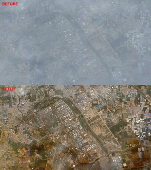 A before reflectance-conversion preview and an after reflectance preview of a very hazy 60-cm color QuickBird image collected over Beijing, China on October 6, 2009.(Image Courtesy: DigitalGlobe)
For these spectral studies, scientists have traditional completed atmospheric corrections (ATOC) which convert unit-less pixel values into radiance and/or reflectance. Now, you can have your next multispectral imagery order converted to reflectance using DigitalGlobe’s and Airbus’ proprietary processing techniques which produce more reliable and accurate results in a fraction of the time. As an added bonus, their correction services are free!
These atmospheric correction services can also improve image quality by reducing atmospheric haze, thereby increasing the number of archive options available to you in cloudy regions.
If you have any questions about DigitalGlobe’s and Airbus’ new atmospheric correction services, please send us an email at sales@apollomapping.com.