
We love maps.
 (Image Courtesy: Airbus. Processed by Apollo Mapping for improved color accuracy and clarity.)
We love imagery.
We love work breaks.
We hope you like them as well!
The Ides of March are upon us and to celebrate, please take a quick work break! But before you head out, take a few minutes to gander over this epic image of the opening round of The Master’s Tournament. Collected on April 7, 2017 by the 50-centimeter color satellite, Pléiades 1B, in this image you can see throngs of people surrounding many of the greens and fairways. We have covered the Master’s before, that time on ‘Moving Day’ in 2013. Coming out of Round 1 in 2017, Charley Hoffman was the leader, shooting a 65, or seven under, on the day–however he would only finish in 22nd after falling behind the eventual winner Sergio Garcia. Enjoy the image!
Have a great rest of your workday!
As government agencies and commercial entities around the world set their sights on Mars and further destinations in space, they are looking to the Moon as a kind of base camp for space exploration.
NASA and its commercial partners envision a space station orbiting near the Moon to facilitate new discoveries. The first step is to design and manufacture the power and propulsion system element. This element is necessary to maintain and adjust the gateway’s position in lunar orbit. NASA selected five companies to come up with propulsion technology solutions. They will need to develop a system that is three-times more powerful than existing systems. They have also solicited proposals for space habitats.
While NASA has its eye on the sky, the European Space Agency (ESA) is digging deep. The ESA is considering all options for the lunar base, from a modular system to subterranean. The most appealing plan is to create a lunar base by turning lunar regolith into construction material. Instead of manufacturing a lunar base and shipping it to the Moon, which comes with numerous logistical challenges and points of failure, 3D printing robots could do the job onsite.
Turning the lunar soil into building material is attractive because it requires the least amount of resources from Earth. Excavating machines or heavy payloads would be unnecessary, saving time and money. Repairs to the structure could be completed quickly without shipping in supplies.
The preliminary design uses an inflatable structure to secure a pressurized internal environment. The lunar regolith would then be printed and placed over the inflatable. The blocks need to be 800 mm thick to protect from radiation, meteorites and thermal gradients. The side facing the sun will need 1500 mm of regolith to protect from solar flares, solar winds and galactic cosmic rays. It is easier to estimate the direction of these forces with plans to place the base at one of the poles. The poles offer better access to frozen water that can be used to create breathable air in the inflatable.
The original study used a saline solution and metal oxides as additives to bind the regolith together, an expensive solution since the additives need to be shipped from Earth. A more recent study used concentrated sun light to bind the dust particles together. The proof of concept was completed using volcanic rock to simulate the moon dust.
Whether floating in space or creating lunar hobbit holes, returning to the Moon appears to be the next stop on our journey through the solar system.
In the nearly two years we’ve published the Mapping for Good series here for our Geospatial Times newsletter, we have covered a wide variety of charitable and sometimes just down-right fun mapping projects around the world. Nearly all of them, however, have focused in way or another on how our world is shifting in the face of global change. With this trend in mind, we thought it would be refreshing to look at a mapping project that analyses worlds long since forgotten. Enter the Theban Mapping Project (TMP) of the American University in Cairo.
 A screenshot of an interactive map allowing users to click on individual tombs within the Valley of the Kings and learn more about each archaeological site.
Since its beginning in 1978, the Theban Mapping Project has been working to prepare a comprehensive archaeological database of the ancient Egyptian city of Thebes. Thebes was a city located on the east bank of the Nile about 800 kilometers south of the Mediterranean, within the modern city of Luxor. Having served as the capital of Egypt during the Middle King and the New Kingdom eras, the city was the most venerated of all Egyptian settlements in its heyday. So why is the project still taking place 40 years later, for a city that stopped growing thousands of years ago? As it turns out, the very issues we’ve covered in our many articles on global change are even effecting the ancient ruins of cultures long since past:
‘With its thousands of tombs and temples, Thebes is one of the world’s most important archaeological zones. Sadly, however, it has not fared well over the years. Treasure-hunters and curio-seekers plundered it in the past; pollution, rising ground water, and mass-tourism threaten it in the present. Even early archaeologists destroyed valuable information in their search for museum-quality pieces.
Today, however, we realize that the monuments of Thebes are a finite resource. If we fail to protect and monitor them, they will vanish, and we and our descendants will all be the poorer. The TMP believes that the first and most essential step in preserving this heritage is a detailed map and database of every archaeological, geological, and ethnographic feature in Thebes. Only when these are available can sensible plans be made for tourism, conservation, and further study.”
With its vulnerable artifacts at the mercy of time, the Theban Mapping Project sees its efforts as more pertinent than ever. With these risks in mind, the project has shifted its focus in the last decade to the famed Valley of the Kings. Having assembled measurements of Theban tombs using modern surveying techniques, the TMP is currently preparing 3D models of the Valley’s contents. In all these efforts, the value of sharing their works’ findings is always viewed as important as the work done in the field. This sharing is accomplished through both academic and more casual publications as well as regular contributions on the group’s website.
To learn more about the Theban Mapping Project and how you can contribute, visit www.thebanmappingproject.com.
Fletcher Berryman
Cloud Tamer
(970) 710-0909
fletcher@apollomapping.com
For many clients using satellite imagery in media applications like movies, television advertisements and newspapers, the traditional end user license agreements delivered with our data will not suffice. Understanding the commercial need for a more flexible media license that can be delivered rapidly, DigitalGlobe now has you covered!
In the past, media licenses were custom in nature and could take one to two weeks (sometimes longer) to put in place. Now, the media license is an out-of-the-box offering by DigitalGlobe so that it adds literally no time to product delivery–yay!

Here are some of the pertinent details about the media license, if we missed anything you would like to know, feel free to email us at sales@apollomapping.com:
- Basic License Language: “DigitalGlobe grants to Customer a perpetual, non-exclusive, non-transferable license to publish extracts of the Product and/or Derivatives of the Product…”
- Full License: download here
- License Cost: adds 20% to base imagery price
- Available Products: all DigitalGlobe satellite imagery from GeoEye-1, IKONOS, QuickBird and WorldView-1/2/3/4
- Average Delivery Time: one to two business days (add one to three business days for value-added services)
Launched in late 2016, Map Mavin is our pay-as-you go GIS cloud that lets users make unlimited public and password-protected web maps. Once you upload your vector and raster files to our secure Amazon cloud, you are ready to make and share your web maps in minutes–just like this demo web map we made with vectors and a base layer TIFF from Boulder, Colorado.

And with our Screen Share function, you can link up with users all around the world to collaborate on a map in real-time. Picture a live WebEx in your mind but just based around a map that moves and changes as the members of your team update information. Imagine the possibilities of working in real-time with a team of collaborators around the world without any GIS knowledge required!
Priced at just $20 per month with a free trial month, there is no other cloud-based GIS on the market that can compete with Map Mavin on price. For your $20 per month, you are able to store and/or download up to 5 gigabytes (5GB); and once you go over 5GB in a month, it costs you just 75-cents per GB from there! As an added bonus, you can cancel your monthly contract at any time.
February 2017 Product Updates
In the past few months, we released Map Mavin updates that included but were not limited to the following list of fixes, additions and enhancements:
- The file format KMZ is now supported for uploads.
- Added the ability to drag and drop (or reorder) layers in webmaps.
- Improved webmap loading times and fixed a bug that caused colored tiles to load before data did.
- Added a new OSM baselayer with more geographic detail.
- Improved billing stability and warning emails (still in progress now).
- We know it has been a long time since we have updated Map Mavin, and we apologize for this! We have a new team in place who will be working on Map Mavin exclusively in the coming weeks. Expect major changes coming soon!!
Stay tuned to this series where we will let you know about the Map Mavin changes that were released in the past month.
If you have an improvement or feature addition you would like to add the Map Mavin product road map, let us know by email at support@mapmavin.com.
Are you interested in trying out Map Mavin? If so, you can sign up here. Or maybe you would like a live demo of the product before you sign up? If so, send us an email at support@mapmavin.com and we will get one scheduled right away!
Every time we look at WorldView-3 and WorldView-4 (WV3/4) imagery, we are blown away. And we hope you are equally impressed with the data! In January, we found ourselves in a coastal South African town, and for this WorldView-3/4 Image of the Month we travel to the Far East with a stop in the rapidly modernizing and expanding city of Shanghai, China.
PLEASE NOTE: Effective May 2016, WorldView-3/4 prices dropped again! Are you interested in finding out more about these price drops? If so, send us an email at sales@apollomapping.com.
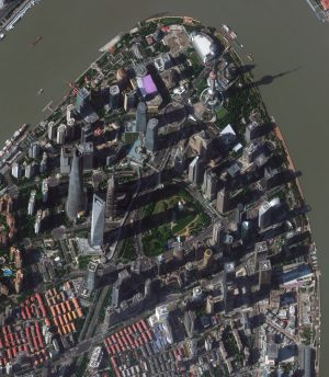 The downtown high-rise district of Shanghai is a site to see! So breaking with tradition this month, we feature a full resolution image of the entire (or nearly the entire) district with tall skyscrapers–enjoy! This 30-cm imagery was collected by WorldView-4 on November 1, 2017 and has been processed by Apollo Mapping for improved colors and clarity. (Images Courtesy: © 2018 DigitalGlobe)
WorldView-3 launched in late 2014 and WorldView-4 launched in late 2016; taken together they are the most advanced satellite constellation the commercial marketplace has ever had access to. Here are a few of the features that really set these satellites apart from the competition:
- Improved Resolution
- Higher resolution means you can see more detail in WV3/4 imagery.
- Data collected at nadir will have 31-centimeter (cm) panchromatic, 1.24-meter (m) visible and near infrared, 3.7-m SWIR (WV3 only) and 30-m CAVIS (WV3 only) bands.
- At 20 degrees off-nadir, the resolution is 34-cm panchromatic, 1.38-m visible and near infrared and 4.1-m shortwave infrared.
- Per US government regulation, all WV3 SWIR orders are produced at a maximum resolution of 7.5-m. CAVIS bands are not available for purchase at this time.
- Additional Spectral Bands
- If spectral analysis is part of your project, then no other satellite can match WV3 with its: 8 bands of visible and near-infrared data; and 8 shortwave infrared bands which are crucial for geological studies.
- Better Positional Accuracy
- With accuracies of 3.5-m CE90% or better (without ground control even!), WV3/4 has no rivals for its enhanced positional accuracy.
- Daily Revisits
- At 40 degrees latitude, WV3/4 will each be able to image every location daily with 1-meter or better resolution and then every 4.5 days at 34-cm resolution or better.
- Increased Collection Capacity
- WV3/4 feature 13.1-km swath widths (at nadir) with the ability to collect up to 680,000 square kilometer (sq km) of high-resolution data per day per satellite.
- Improved control movement gyros translate into larger maximum contiguous collection areas per pass, with up to ~7,500 sq km of mono imagery and ~3,000 sq km of stereo possible.
If you are interested in WorldView-3 and/or WorldView-4 imagery for your next project, please let us know by phone, 303-993-3863, or by email, sales@apollomapping.com.
You can also find more WV3 samples and technical information on our website here and then WV4 samples and information can be found here.
I have traveled an awful lot in my life, mostly stateside, covering them all–almost. I’ve got 5 left to hit in order to have visited each one. I know there is no prize, but for whatever reason I’d like to “see” them all, even if I’m just driving through. That’s what Oklahoma is to me, a place I drove through on my way back to Colorado. I only stepped foot on Oklahoma soil once. That was enough. But today I’m not here to write about my travels explicitly, but more about how much I hate them. I hate to travel, yet I do it so much and have done it for so long. A lot of this is because I’ve lived all over the country and in order to keep up with my friends and family I have to travel. You see, I don’t believe in “keeping up” via social media; in fact, I have no social media presence. I figure if you’re going to call someone a friend, you have to seem them fairly regularly. Once a year would be ideal (assuming you live states away from one another), every other year in a worst case scenario. Otherwise, it’s simply not worth the effort and maintenance. I’m one of those people who likes to purge things from my life. There is great joy in getting rid of something you don’t need, I also find it in erasing entries in my phone. Now, it appears, I’m going to erase people from my life. Well, not quite; at least not quite yet.
 Fly the friendly skies.
Anyone that flies knows how horrible the process is; we’re cattle, mooing along, paying more and more for less and less. Being an overzealous planner who rarely thinks of the consequences until they slap me in the face, I have become somewhat notorious for stacking trips up, one after another after another, sometimes three in a row or more. It gives you no time for yourself, costs an arm and a leg, and makes you hate your life. Fun. Well, add to that the discomfort that comes along with travel and that only compounds everything, definitely making it worse. I was always willing to pay extra to avoid a connection, and I’ve recently become willing to pay for the seat I want: an aisle as close to the front of the plane as possible. But that really isn’t enough. After having just struggled through one trip a few days ago and having another to look forward two days from now, I now know it is time to move to first class. This will cost an awful lot more, but I’ve already reached the end of comfort. I can’t stand it. I need some back. They used to say people would “go postal” when they went on a rampage; I think it may be more appropriate these days to say we “go airline” because of all the pains that accompany it.
But it isn’t just airline flights that really break me, it is the car rides and train rides too. Some trips have a full day of travel on either end, making nearly half of some of my trip hours being allocated solely to transportation. That sucks, big time. This is part of the reason I go abroad so rarely: I never want to travel for too long (5-6 days, max), and to go to a distant country would leave me with 3 days onsite after travel on that type of schedule; it doesn’t work. Trust me, I’ve tried. So unless I want to go somewhere for 10 days or longer, which I don’t, then travel doesn’t make sense. So I don’t “see the world.” Oh, well. I’ve still got 5 states left to see anyhow… But I digress (as usual).
What I think I’m going to do is cut my number of trips way back. For one, I’m just plain sick of traveling in general. For another, this will keep me from taking trips I don’t really need/want to take; those I embark on because of a whim. And in their place I’ll travel more comfortably, at least on the plane, by going first class. If I cut back my flight-based trips from 6-7 a year to 2-3, then the cost savings will be substantial (flight, hotel, food/booze, parking, rental cars, assorted nonsense, etc.). Now, flying first class won’t greatly improve all of the trip, just the flight (as much as possible). But maybe there will be a residual effect that improves other areas of the trip because I won’t be tired, cramped and pissed off. If nothing else I can revel in other’s misfortune from having to go to the back of the plane. Schadenfreude. That makes everything worthwhile!
They let the first class cabin board first; but why would you want to do that? Why would you want to be on that plane any longer than possible? As someone who sits in the peon seats, I go on as early as possible to get some overhead space; that’s it. It certainly isn’t that I want to hang out in the terminal any longer than necessary either, but the whole traveling process is two sides of screwed, so you pick your poison, I guess.
Another thing I hate about airplane flights is people. When you get a bunch of them crammed in a space like that, it’s overwhelming. I don’t know how anyone can come away from a flight being happy with life or humankind. It must be the breeding ground for all hate. Just add canned air… I’ve been trying to find a water bottle that has a spout cover to keep all the diseases off my beverage. People are always hacking and sneezing, spraying their filth everywhere. People just have no tact or decency. It is never clearer than on an airplane.
So, in our world today, we have reached the end of comfort. And this is not just in travel. We’ve clearly reached it because nobody is happy with what they have. We’re always looking for the next best thing because why? We haven’t been satiated. Sure, marketing gurus trick us into our ephemeral indulgences and we discard and discard again, always chasing the life of leisure and comfort, but we never really find it. We can’t. We won’t. Not in this system, anyways. So where does that leave us? What can we do to have a little joy, especially in the least joyful of places, airplanes? First class. Let the suckers brag about their savings and struggle through the pains of the back of the plane; all those disgusting, sickly, poor excuses for civil beings, you can have them. From now on, for me, it’s up front and personal–comfort. I’ll be the guy laughing at you when you go find your seat next to the toilet, screaming baby, fat guy who encroaches on your space, and the woman who is coughing SARS all over your peanuts.
Marco Esquandoles
Jetset
We love maps.
We love imagery.
We love work breaks.
We hope you like them as well!
 (Images Courtesy: © 2018 DigitalGlobe. Processed by Apollo Mapping for improved color accuracy and clarity.)
February is here and so winter is half over, let’s rejoice with a work break! But before you head outside on that 15-minute (at least!) break, check out this 50-centimeter black and white WorldView-1 image collected over the Dubai Airshow 2017 on November 13, 2017. We covered the event in a 2015 Your Imagery Work Break so we are back again to offer an update! The 2017 version of the Dubai Airshow saw a 20% increase in attendance over 2015 with about 79,000 visitors in the 5-day event. There were nearly $113.8 billion in orders signed at the Airshow and a whopping $49.5 billion signed by Airbus alone–read more of the eye popping stats here.
Have a great rest of your workday!