
Planet is now offering high-resolution SkySat imagery at 50-centimeter (cm) resolution with impressive revisit times. SkySat is a constellation of satellites continuously growing as Planet launches new ‘birds’ every year. Currently, the SkySat constellation revisits a site up to 3 times a day, and with upcoming launches this year that number will soar to up to 12 revisits a day, making it an ideal choice for high-resolution monitoring applications.
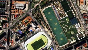
 Several 50-cm natural color SkySat imagery samples collected over Madrid, Spain on April 3, 2020. With 81-cm multispectral data, these images have color detail not seen in previous high-resolution satellite missions. These images have been processed by Apollo Mapping for improved clarity and colors. (Images Courtesy: Planet)
While previous SkySat satellites collected at lower resolutions, the vast majority of imagery collected from 2020 on can be delivered as a 50-cm 4-band pansharpened product. Further, all new and previously launched SkySat satellites (other than SkySat-1 and 2) now have a native resolution of 65-cm panchromatic and 81-cm 4-band multispectral (i.e. blue, green, red and near-infrared). Using an innovative system, Planet applies super-resolution processing to improve the quality of their high-resolution imagery to 50-cm.
Here is a summary of SkySat’s impressive specifications:
- Equatorial Crossing Time: 10:30 local time; 13:30 local time for only October 31, 2017 launched sats (approximate; across lit side of Earth); SkySats 16–21 crossing times vary daily, with a shifting ~3 hour access window per day
- Revisit Frequency: 3 to 12 times per day with the entire constellation (latitude dependent, pending additional 2020 launches)
- Sensor Resolution:
- Pre-2016 sats–90-cm panchromatic & 1.0-m multispectral (at-nadir, 500 km altitude)
- 2016 to October 2019–72-cm panchromatic & 1.0-m multispectral (at-nadir, 500 km altitude); transition to 50-cm panchromatic started about October 2019
- July 2020 and on–65-cm panchromatic & 81-cm multispectral (at-nadir, 500 km altitude); SkySats 1/2 remain at 72-cm panchromatic & 1.0-m multispectral; delivered as pansharpened 50-cm 4-band imagery through super-resolution processing
You can search for SkySat coverage 24-hours a day by using Image Hunter. If you have any pricing requests, additional questions or would like a new price list with SkySat data added in, send us an email at sales@apollomapping.com! Or check out our website in the meantime for additional 50-cm samples and more detailed SkySat specifications.
By now you might have heard that medium-resolution satellite imagery from SPOT 1, SPOT 2, SPOT 3, SPOT 4 and SPOT 5 has been removed from Airbus Defense and Space’s Geostore? If not, we are sorry to break the news to you!
 A SPOT 5 preview over Boulder, Colorado from June 2011 as seen on Image Hunter.
But we do have some good-ish news for you as well as we have no plans to remove SPOT 1 to 5 imagery from Image Hunter. Now sure, we will not be able to order these images now that the catalogue has been removed from the Geostore but for now you will at least be able to query the historic archive that can date back to 1986 in some locations.
Representing one of the longest standing continuous records of medium-resolution land observation data, we fully expect a new company or perhaps a European space agency to take up the mantle and start providing access to SPOT 1 to 5 imagery again. But until that time, at least you can still find the archive on Image Hunter–and as soon as we hear updates on its new ‘home,’ we will be sure to update our readers.
If you have any additional questions about SPOT 1 to 5 medium-resolution satellite imagery, feel free to drop us an email anytime at sales@apollomapping.com.
Admittedly, I felt a little odd not being back on the Eastern seaboard as the protests surrounding George Floyd’s death–and police brutality in general–spread across the country. Here I was, nestled in a place of comfort somewhere in a hidden crevasse of the Rocky Mountains. It was a conflicting set of feelings: I’m safe, I have no worries of incivility or violence, but at the same time, I felt like I was absconding some moral and civic duty by not being involved in the protests somehow. Yet running parallel with these thoughts was the question, “Why now?” There have been murders of innocent black people by cops for–well, forever, maybe, at least from Reconstruction on. There have even been dozens (if not more) of these heinous acts caught on tape. So, it was obvious to me that Covid-19 played a role in the protests (as well as the riots and looting, where those occurred): people are out-of-work, and have been for some time; most social avenues have been paused for quite some time; and the weather is getting better, so people feel an inherent need to be outside. This may come across as a grim, or even cynical, take on things, but I don’t believe that what we see right now would be taking place at the level it is without all those factors being in play. While it is comforting to see these movements sustaining, including around the world, and it’s heartening to see the public displays of art and community awareness, I can’t help but think the moment will, yet again, be wasted. The talk of climate change and Greta Thunberg has dissipated; the March for Our Lives movement and the strong students of Marjory Stoneman Douglas have also faded into the social commentary abyss. News cycles turnover frequently, and I think with the resurgence of Covid-19 and the impending presidential election, we’ll miss any chance for substantive changes.
I lean pessimistic, that’s for sure, but I’m also left wondering what would be the type of changes people on an aggregate level would want–let alone agree to. I know the phrase “defund the police” is in vogue, and at face value it is ridiculous, but once it is analyzed intricately, there is much to take away from it. First, police are asked to do too much and are not trained correctly, if at all, for a lot of it. Dealing with mental health issues, substance abuse issues, homelessness, and even most petty offenses should not be in the hands of municipal, county or state law enforcement; those issues require trained healthcare, social workers, psychologists, mediators, etc. to handle the issues correctly and without escalation. Obviously, the police need to be demilitarized as well; that anyone would concede to having gestapo-like foot soldiers trained to kill within an ever-expanding surveillance state is worrisome. All of that seems like a good and reasonable place to start. But what else is needed and realistic?
I think there is a more-than-compelling argument to make that the evidence of structural or systemic racism in this country runneth over, and has for quite some time. But how to respond there? For decades there have been calls for reparations, but this is a sticky issue. I assume you could say that anyone who is a direct descendent of someone who was enslaved in this country would be eligible, but for how much? Where would that money come from? Frankly, I don’t think it is right or realistic to extend checks to individuals on a personal level, but I do think it would be more-then-reasonable to build up the areas that have been torn down and downtrodden by structural racism by improving schools/education, access to healthcare, job training, infrastructure (social and physical), and community/neighborhood safety. That is realistic. Leveling the playing field–which will require a lot of investment in many areas–is essential. But how do we pay for that?
 Invest in what is owed its due, including for past transgressions. It might just make life in the future better for everyone.
As I’ve oscillated between some form of libertarian and some form of socialist in my life–still never finding a proper camp to call “home”–I think the best way to do so is through new forms of taxation. This will yield groans from many, but in addition to having not raised the federal gas tax in 27 years, there are other things that warrant taxation, which, if done, not only will help the social infrastructure and lives of those marginalized and oppressed, but also help curb consumerism and waste, and add benefits to the natural environment as well. So, raise the gas tax by a minimum of 25₵ a gallon, but also the taxes on all non-essential goods that aren’t directly related to a healthy lifestyle (e.g., TVs, smartphones, designer apparel), products that are excessive in their grandiosity and lacking in need (e.g., 250+ HP cars; 5,000 sq. ft. homes), as well as all unhealthy forms of food (e.g., candy and cookies). People in this country bitch way too much about paying taxes, when the reality of us paying more wouldn’t greatly affect our livelihood if we’re living enjoyable, yet pragmatic, lives. People need to make a commitment to a better now and a better future, and that requires payment and a little bit of sacrifice. To be clear, this isn’t taking anything off the market–you could still by your Dodge Challenger Hellcat with its 700+ horsepower that tops out at 200 mph–it’s just that it’s beyond time for people to start paying their fair share for the damages they do/have done to society and the environment. The Hellcat stickers at around $60k for the base model; let’s put a 10% tax on that for the environment and infrastructure; after all, you’re going to be using that 700+ HP on publicly-funded roads, aren’t you? All those emissions you’re going to be dumping into the air; that affects all of our ability to breathe, right?
So, as we go back to improving the lives of those who have experienced systemic racism and oppression for decades, if not centuries, then let’s explore what are the issues that are in need of assistance, and look at what types of consumption have played into that and tax there as well. For instance, we know that foods high in sugar, saturated fats and cholesterol all lead to poor health, and thus place a burden on our healthcare industry as well as those who, in many instances, have fewer options because of lack of access to healthy foods–commonly due to residing near a food desert. Coca Cola and Kellogg’s and Hostess need to be taxed for dumping such junk into our markets and onto our tables. If they want to run ads on TV or online, there should be taxes on that too. Why should we let companies that openly exploit us through garbage food, which negatively affects our health and strains our healthcare industry, off scot-free? Again, this isn’t to say that you can’t still get your Big Gulp, just that you’re going to pay more for it because the companies are taxed from the outset. Use taxes would go along way; look how it has impacted tobacco sales (although other types of campaigns and PSAs helped there as well). “Sin taxes” need to be extended to the bigger social and environmental degradations they cause.
Most people who have been cast away by society live in areas that are closer to industries, toxic runoffs, landfills, noise pollution, etc. All of these businesses that have contributed to environmental and social degradation should be taxed, heavily. And, of course, this cost will go onto the consumer. Those pesticides you want to dump on your lawn? That’s gonna go up 100%, at least. That old TV you want to dump in the landfill that is loaded up with metals and toxins of its own, well, we know you’re going to do that (because you’re too cheap to pay the recycling fee), so you’ll pay for the hazardous waste cleanup on the frontend. The same for your old tires, the cans of paint you’re going to buy because you want the foyer to be periwinkle, the motor oil from your lawnmower, the plastics your prewashed salad and your loose vegetables come in. All of it. Maybe it’ll cause you (us) to think about what we buy and why, to be intentional about every purchase, to use everything we buy, not just throw it away because it’s cheap and easy to do so–we should not be rewarded with no penalties for creating more waste. All of that money will not only help us to streamline our junk and consumption, but it will improve the environment, and it will go a long way to making material improvements in the lives of those who have been cast away like the cheap products we can’t seem to live without…
Yeah, I’m in a place of comfort, I guess, but I’m also watching what’s going on–and have been for quite some time. No, I’m not innocent, far from it. But I am aware, and I have to accept that concessions need to be made, improvements need to be made, commitments need to be made. So, how was I ever a libertarian, you might ask? In some ways, I still am: I still believe that we shouldn’t do anything that directly–or indirectly–negatively impacts others’ quality of life. That’s pretty libertarian. Of course, that comes with the don’t impose your laws on me, my body, and my property, and sure as hell don’t tax me out of existence, but there has to be a middle road. If you’re going to live in a society, then you’re going to have to pay for it (taxes). If you’re going to be a contributing and aware member of society, you also have to accept that “society” will make mistakes–oftentimes major ones–and we’ll have to pay for those too, especially when it’s beyond overdue. For instance, I had a dogsitter watch my dog for a weekend once; the dog stayed at her house. Well, when I came to pick her up, I learned that she jumped on the washing machine to bark at a squirrel and in the process knocked over a few pieces of inexpensive glass objects. Now, it could be argued that the dogsitter should have created an environment where that wouldn’t have happened–the dog could’ve been hurt, after all–but it also suggests that I am responsible for what my dog does while in someone else’s home; so, of course I paid for the items. We’ve got a lot of stuff we broke decades and centuries ago and it’s time to pay our bill. It might hurt the pocketbook a little at first, but it’s the only road forward. It also might allow us to see how we’re wasting in other areas, too. Think of it as spring cleaning for our country: let’s make it a better place for the future, and that means taking care of all the waste and hurt we caused along the way.
Marco Esquandoles
The Idea Guy
Vricon is pleased to announce to our friends of Apollo Mapping’s newsletter that Maxar has completed its acquisition of Vricon. Vricon will be integrated into Maxar’s Earth Intelligence business.
Vricon was a joint venture between Maxar and Saab. This summer, Maxar exercised the option to acquire the remaining 50% of Vricon. This opens up many avenues for both Vricon and Maxar, as they complement each other’s offerings.

You might be asking “What does this mean for me, a loyal Apollo Mapping customer?”
It means improving existing products, enabling new products, and innovating toward game-changing opportunities. With the exciting and much-anticipated launch of the WorldView Legion satellite constellation in the coming months, the possibilities are endless.
Vricon’s unfettered access to Maxar’s massive, industry-best imagery libraries — from existing WorldView satellites and the new WorldView Legion constellation — will be leveraged as we continue to innovate and produce our 3D products, always meeting the needs of future technology. Vricon will be able to provide more 3D data, at a faster rate, with increased resolution, to both our loyal and new Apollo Mapping customers.
We are confident that you will be as pleased with this development as we are. Vricon, Maxar and Apollo Mapping are excited to be Moving Forward Together.
(We know some of our readers would like the formal details, if so please check out this full press release.)


As a result of COVID-19, most GIS conferences around the world have been either cancelled, postponed or transitioned to a virtual format. The benefit of the virtual format is that attending is either free, or the fee is heavily reduced, so you can attend many GIS conferences around the world from the comfort of your home. Unfortunately, many of them do remain in the dark as to how they will host it virtually, and on their final costs.
Three 2020 conferences that are confirmed as completely free are the Esri Education Summit on August 6-7, EuroCarto on September 21-25, and SPIE (The International Society for Optics and Photonics) from September 21-24. Registration is not yet available for EuroCarto or SPIE, however you can register for the Esri conference here. A cheap to attend conference (costing only $10) is IGARSS (the IEEE International Geoscience and Remote Sensing Symposium) from September 26th to October 2nd. If you are interested in participating in a free virtual mapathon, check out the Missing Maps London event.
Several events that either have fees to attend or have not yet announced their full plans include the Harris Geospatial Virtual EAS ENVI Analytics Symposium, August 25-27 (cost break-down found here), the UCL 3D GeoInfo 2020 and BIM GIS Integration Workshop from September 7-11 (costs found here), The Fifth International Conference on Smart City Applications from October 7-9 (fees found here), the 23rd ICE Workshop on Map Generalisation and Multiple Representation from November 5-6 (registration not yet available), and the Commercial UAV EXPO Europe from December 1-3 (pay structure and registration not yet announced, but more information can be found here).
We hope that attending these mapping and GIS conferences gives you a way to stay busy and involved during these strange times! Remain focused on learning and the world will heal itself soon.
Jake Zatz
Social Media Guru
We love maps.
 (Satellite imagery © 2020 Maxar Technologies. Processed by Apollo Mapping for improved color accuracy and clarity.)
We love imagery.
We love work breaks.
We hope you like them as well!
Can you believe it’s August already?! Well since we can’t stop time, add to the enjoyment of your day by heading out on a quick walk around the block! But before you head out, take a gander at this 50-cm WorldView-2 image collected of the 2018 Austrian Grand Prix on July 1st at Red Bull Ring outside of Spielberg, Austria. This image was collected at 12:18 local time, about 3 hours before the start of the race which was schedule for 15:10, so you can see the extent of the pre-race scramble. Now admittedly we’re sports fan but we know little about Formula 1 racing, so it was pretty amazing to see the elaborate celebration and wide-spread camping that surrounds a race weekend! The 2018 Austrian Grand Prix was won by Red Bull driver Max Verstappen who became the youngest driver (17 years and 166 days) to compete in F1 racing at the 2015 Australian Grand Prix.
Have a great rest of your workday!

Cricket’s Chirp is created for Apollo Mapping by Ron Ruelle, a Boulder, Colorado based cartoonist, lllustrator and teacher. No animals are harmed in the creation of these comics, but Ron sometimes breaks a pencil in frustration. You can see more of his work at www.ronruelle.com
Every time we look at WorldView-3 and WorldView-4 (WV3/4) imagery, we are blown away. And we hope you are equally impressed with the data! Last month we checked out a historic Spanish city, and for our August edition of the 30-cm Color WorldView-3/4 Image of the Month we travel west to the site of a Romanian medieval star fort, Oradea.

 The star fort at the center of the Romanian town, Oradea Fortress, has a long history of siege, destruction and resurgence; and the version that remains today, appears to have been re-constructed in the 16th Century by Italian architects. The second image here of Oradea is not of a unique location but what drew our attention were the opposing bright red and blue rooves! This 30-cm WorldView-3 image was collected on March 17, 2019 and has been enhanced by Apollo Mapping for improved colors and clarity. (Satellite Imagery © 2020 Maxar Technologies)
PLEASE NOTE: Effective May 2016, WorldView-3/4 prices dropped again! Are you interested in finding out more about these price drops? If so, send us an email at sales@apollomapping.com.
WorldView-3 launched in late 2014 and WorldView-4 launched in late 2016; taken together they are the most advanced satellite constellation the commercial marketplace has ever had access to. Here are a few of the features that really set these satellites apart from the competition:
- Improved Resolution
- Higher resolution means you can see more detail in WV3/4 imagery.
- Data collected at nadir will have 31-centimeter (cm) panchromatic, 1.24-meter (m) visible and near infrared, 3.7-m SWIR (WV3 only) and 30-m CAVIS (WV3 only) bands.
- At 20 degrees off-nadir, the resolution is 34-cm panchromatic, 1.38-m visible and near infrared and 4.1-m shortwave infrared.
- Additional Spectral Bands
- If spectral analysis is part of your project, then no other satellite can match WV3 with its: 8 bands of visible and near-infrared data; and 8 shortwave infrared bands which are crucial for geological studies.
- Better Positional Accuracy
- With accuracies of 3.5-m CE90% or better (without ground control even!), WV3/4 has no rivals for its enhanced positional accuracy.
- Daily Revisits
- At 40 degrees latitude, WV3 is able to image every location daily with 1-meter or better resolution and then every 4.5 days at 34-cm resolution or better.
- WV4 is no longer collecting new imagery.
- Increased Collection Capacity
- WV3/4 feature 13.1-km swath widths (at nadir) with the ability to collect up to 680,000 square kilometer (sq km) of high-resolution data per day per satellite (though WV4 is dead now).
- Improved control movement gyros translate into larger maximum contiguous collection areas per pass, with up to ~7,500 sq km of mono imagery and ~3,000 sq km of stereo possible.
If you are interested in WorldView-3 and/or WorldView-4 imagery for your next project, please let us know by phone, 303-993-3863, or by email, sales@apollomapping.com.
You can also find more WV3 samples and technical information on our website here and then WV4 samples and information can be found here.