
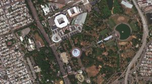
 Roland Garros Stadium, known locally as Stade Roland Garros, is a complex of tennis courts located in Paris, France that hosts the French Open. The complex is named after Roland Garros (1888–1918), a French pilot who completed the first solo flight across the Mediterranean Sea and invented the first forward-firing aircraft machine gun. In World War I, he shot down four enemy aircraft but was killed in aerial combat in October 1918. The stadium was built in 1928 to host France’s first defense of the Davis Cup. The 34-acre complex includes 20 courts, including three large-capacity stadiums; Les Jardins de Roland Garros, a large restaurant and bar complex; Le Village, the press and VIP area; France’s National Training Centre (CNE); and the Tenniseum, a bilingual, multimedia museum of the history of tennis. It also has a retractable roof with a revolutionary design for Philippe-Chatrier court. For the Paris 2024 Games, Roland Garros hosted not only the tennis and wheelchair tennis competitions, but also boxing and sitting volleyball. The stadium regularly gives tours to visitors. The 30-cm WorldView-3 image of Roland Garros Stadium was captured on August 4, 2024 at 1:06 pm when the Men’s Final and Women’s Doubles Final were being played there. Also spied in the southeast quadrant of the image is Deutches Haus, a meeting place for German Athletes during the Paris 2024 Olympic and Paralympic Games at the Stade Jean Bouin. The stadium opened in 1925 and is named after the athlete Jean Bouin, the 5,000-meter silver medalist from the 1912 Olympics. The top 14 rugby union side plays its home games at the 19,904-seater stadium which was also the venue for the France Sevens leg of the World Rugby Sevens Series in 2005, 2006, and from 2017 to 2020. It also hosted the Opening Ceremony of the 2018 Gay Games. (Satellite Imagery © 2024 Maxar Technologies)
Every time we look at WorldView-3 and WorldView-4 (WV3/4) imagery, we are blown away. And we hope you are equally impressed with the data! In September, we marveled over images of Fairmont Chateau Lake Louise at Banff National Park in Canada. For this edition of the 30-cm Color WorldView-3/4 Image of the Month, we examine images of Roland Garros Stadium in Paris, France collected during the Paris 2024 Summer Olympics!
WorldView-3 launched in late 2014 and WorldView-4 launched in late 2016; taken together they are the most advanced satellite constellation the commercial marketplace has ever had access to. Here are a few of the features that really set these satellites apart from the competition:
- Improved Resolution
- Higher resolution means you can see more detail in WV3/4 imagery.
- Data collected at nadir will have 31-centimeter (cm) panchromatic, 1.24-meter (m) visible and near infrared, 3.7-m SWIR (WV3 only) and 30-m CAVIS (WV3 only) bands.
- At 20 degrees off-nadir, the resolution is 34-cm panchromatic, 1.38-m visible and near infrared and 4.1-m shortwave infrared.
- Additional Spectral Bands
- If spectral analysis is part of your project, then no other satellite can match WV3 with its: 8 bands of visible and near-infrared data; and 8 shortwave infrared bands which are crucial for geological studies.
- Better Positional Accuracy
- With accuracies of 3.5-m CE90% or better (without ground control even!), WV3/4 has no rivals for its enhanced positional accuracy.
- Daily Revisits
- At 40 degrees latitude, WV3 is able to image every location daily with 1-meter or better resolution and then every 4.5 days at 34-cm resolution or better.
- WV4 is no longer collecting new imagery.
- Increased Collection Capacity
- WV3/4 feature 13.1-km swath widths (at nadir) with the ability to collect up to 680,000 square kilometer (sq km) of high-resolution data per day per satellite (though WV4 is dead now).
- Improved control movement gyros translate into larger maximum contiguous collection areas per pass, with up to ~7,500 sq km of mono imagery and ~3,000 sq km of stereo possible.
If you are interested in WorldView-3 and/or WorldView-4 imagery for your next project, please let us know by phone, 303-993-3863, or by email, sales@apollomapping.com.
You can also find more WV3 samples and technical information on our website here and then WV4 samples and information can be found here.
NASA is paving the way for the next generation of STEM leaders–and they’re looking to HBCU scholars to help lead the charge. At the 2024 HBCU Week National Conference, NASA showcased a bold initiative to connect students at Historically Black Colleges and Universities (HBCUs) with groundbreaking opportunities in science, technology, engineering, and mathematics. From cutting-edge research to internships, NASA is putting its resources into action, giving HBCU students direct access to a future that’s out of this world–literally.
 NASA’s MUREP program grants HBCU scholars access to NASA technology, networks, training, resources, and partners as part of the White House’s initiative for educational equity and economic opportunities. (Credit: Christina Morillo)
As part of the conference, NASA is organizing MITTIC, a hackathon that will challenge students to come up with innovative solutions for the betterment of humanity. The focus of the MITTIC HBCU hackathon is on utilizing NASA technologies to tackle common challenges faced by HBCU campuses. Teams of scholars will apply NASA technology to address the challenge they choose, then a panel of subject matter experts will hear pitches from each team’s concepts. The team that wins will get a cash prize.
The agency’s efforts go beyond just recruitment. By building long-term partnerships with HBCUs, NASA is actively fostering a diverse pipeline of talent ready to take on the challenges of space exploration, climate research, and everything in between. At the conference, NASA highlighted programs like fellowships, internships, and research grants that open doors for HBCU scholars to engage in some of the most ambitious projects in modern science.
One of the most exciting aspects? The chance to get hands-on with NASA’s Artemis program, which aims to return humans to the Moon and ultimately send astronauts to Mars. Through interactive workshops and networking events, students aren’t just spectators–they’re getting a front-row seat to the future of space travel, with a chance to leave their own mark on it.
For more details, check out NASA’s official announcement and explore the HBCU Week National Conference.
We love maps.
We love imagery.
We love work breaks.
We hope you like them as well!
On September 10, 2022, two incredibly talented female athletes squared off in the women’s final match of the U.S. Open. Iga Świątek and Ons Jabeur used all their skills and might, and put on quite the show. Jabeur put up a battle, but in the end, Swiatek won her first U.S. Open title. In fact, when she realized she had won, she fell onto her back and covered her face as it sunk in that she had just become a three-time grand slam champion at just 21 years old. She also had become only the second woman in the Open era to win all three of her first three grand slam finals in straight sets.
If you’re a big tennis fan or simply stunned by Swiatek’s success on the court, you’ll love the image we’re sharing with you this month. It’s of the Arthur Ashe Stadium in Flushing Meadows–Corona Park in Queens, New York City. For this month’s Imagery Work Break, we have a 50-centimeter color GeoEye-1 image from September 10, 2022, looking down on New York City and the stadium.
In this image, we can see the unique shape of Arthur Ashe Stadium, the high-sided retractable roof, the crowds packed in the stands surrounding the court, and two other enclosed smaller stadiums along with multiple open courts. In 2005, the color scheme for the courts was changed from green to electric blue inner courts and a light green outer court. All US Open Series events now use this color scheme, providing television viewers a more easily trackable ball — with the yellow tennis balls contrasting more visibly against the blue courts. There’s also a very dense neighborhood on both sides of the spacious property where the stadium sits. The stadium was built on the site of the United States Pavilion, which was built for the 1964 New York World’s Fair and demolished in 1977.
Have a great rest of your workday! 😊
(Image Courtesy: Maxar. Processed by Apollo Mapping for improved color accuracy and clarity.)
¡Bienvenidos a octubre! Nosotros en Apollo Mapping estamos gustosos de tenerlos otro mes aquí en los resúmenes españoles del mes de octubre.
Producto Destacado–Descarga Gratuita de Datos Demo de TerraSAR-X (TSX) sobre Hawái
Apollo Mapping ahora ofrece una descarga gratuita de una pila de capas de seis resoluciones del radar de apertura sintética TerraSAR-X (TSX) recogidas sobre el estado de Hawái, en EE.UU. La descarga incluye más de 9 GB de datos en formato CoSSC, ideal para interferometría. Todos estos datos demo de TSX SAR fueron recogidos con polarización HH.
 Una imagen SAR de polarización HH TerraSAR-X SpotLight de 1 m, recogida sobre Tucson, Arizona.
TerraSAR-X proporciona imágenes de radar en banda X de baja, media y alta resolución con varios modos de adquisición. Nuestra pila de capas SAR de Hawái muestra los seis modos de recopilación, incluidos Starling SpotLight, High Res SpotLight, SpotLight, StripMap, ScanSAR y Wide ScanSAR, con resoluciones que van desde 25 centímetros (cm) hasta 40 metros (m).
Si estás interesado en la detección de cambios, el mapeo de movimiento superficial y el mapeo de terrenos, descarga estos datos gratuitos para comprobar si TerraSAR-X es adecuado para tu aplicación.
Puedes acceder a estos datos gratuitos de TSX sobre Hawái contactandonos en: sales@apollomapping.com.
Colecciones de Imágenes de Alta Resolución–WorldView-2/3–China y Rusia, Marzo a Mayo 2024
En esta sección mensual, ofrecemos a nuestros lectores una visión de la cobertura de imágenes de alta resolución recolectadas sobre una geografía durante un período de tiempo específico. Para ello, seleccionamos una constelación de satélites de alta resolución, un período de tiempo definido y un área de interés, luego informamos estadísticas clave sobre la cantidad total de imágenes recolectadas en kilómetros cuadrados (km²). Sin más preámbulos, vamos a nuestro análisis.
 Este mapa muestra las áreas capturadas por la constelación WorldView-2/3 del 1 de marzo al 31 de mayo de 2024 sobre China y Rusia. Ten en cuenta que en muchos casos se recogieron múltiples imágenes sobre la misma área, lo que es difícil de representar en este mapa estático.
Región Gráfica de Interés: China y Rusia, incluidas las islas costeras
Superficie Terrestre Cubierta: 26,298,197.0 km²
Período de Tiempo: 1 de marzo al 31 de mayo de 2024
Constelación de Satélites de Alta Resolución: WorldView-2/3
Estadísticas de Imágenes de la Constelación WorldView-2/3–China y Rusia
Área Total Recolectada: 21,737,338.8 km²; 118,137.7 km² por satélite/día
Área Recolectada con un 20% o Menos de Nubes y 30 Grados o Menos de Nadir: 9,315,646.5 km²; 50,628.5 km² por satélite/día; 42.9% del total
Imagen del Mes en Color WorldView-3/4 de 30 cm–Estadio Roland Garros, Juegos Olímpicos de París 2024
Cada vez que observamos las imágenes de WorldView-3 y WorldView-4 (WV3/4), nos quedamos impresionados. ¡Esperamos que tú también te sientas igual de impresionado con estos datos! En septiembre, nos maravillamos con imágenes del Fairmont Chateau Lake Louise en el Parque Nacional Banff, en Canadá. Para esta edición de la Imagen del Mes en Color WorldView-3/4 de 30 cm, examinamos imágenes del Estadio Roland Garros en París, Francia, capturadas durante los Juegos Olímpicos de Verano de París 2024.
El Estadio Roland Garros, conocido localmente como Stade Roland Garros, es un complejo de canchas de tenis ubicado en París, Francia, que alberga el Abierto de Francia. El complejo lleva el nombre de Roland Garros (1888-1918), un piloto francés que completó el primer vuelo en solitario a través del Mar Mediterráneo y que inventó la primera ametralladora sincronizada para aviones. Durante la Primera Guerra Mundial, Garros derribó cuatro aviones enemigos, pero fue abatido en combate aéreo en octubre de 1918. El estadio fue construido en 1928 para albergar la primera defensa de Francia en la Copa Davis. El complejo de 34 acres incluye 20 canchas, incluidas tres estadios de gran capacidad; Les Jardins de Roland Garros, un gran complejo de restaurantes y bares; Le Village, el área de prensa y VIP; el Centro Nacional de Entrenamiento de Francia (CNE); y el Tenniseum, un museo bilingüe y multimedia sobre la historia del tenis. También cuenta con un techo retráctil con un diseño revolucionario para la cancha Philippe-Chatrier. Para los Juegos de París 2024, Roland Garros fue sede no solo de las competiciones de tenis y tenis en silla de ruedas, sino también de boxeo y voleibol sentado. El estadio regularmente ofrece visitas guiadas a los visitantes. La imagen de 30 cm de WorldView-3 del Estadio Roland Garros fue capturada el 4 de agosto de 2024 a la 1:06 p.m., cuando se jugaban las finales masculinas y de dobles femeninos. También se puede ver en el cuadrante sureste de la imagen el Deutsches Haus, un lugar de encuentro para los atletas alemanes durante los Juegos Olímpicos y Paralímpicos de París 2024 en el Stade Jean Bouin. El estadio, inaugurado en 1925, lleva el nombre del atleta Jean Bouin, medallista de plata en los 5,000 metros en los Juegos Olímpicos de 1912. El equipo de rugby union Top 14 juega sus partidos en casa en este estadio de 19,904 asientos, que también fue sede de la etapa Francia Sevens del World Rugby Sevens Series en 2005, 2006, y de 2017 a 2020. También fue sede de la Ceremonia de Apertura de los Gay Games en 2018. (Imagen satelital © 2024 Maxar Technologies)WorldView-3 se lanzó a finales de 2014 y WorldView-4 se lanzó a finales de 2016; En conjunto, son la constelación de satélites más avanzada a la que el mercado comercial ha tenido acceso. Estas son algunas de las características que realmente diferencian a estos satélites de la competencia:
- Resolución Mejorada
- Una resolución más alta significa que puede ver más detalles en las imágenes WV 3/4.
- Los datos recogidos en el nadir tendrán bandas pancromáticas de 31 centímetros (cm), 1,24 metros (m) visibles e infrarrojas cercanas, SWIR de 3,7 m (solo WV3) y CAVIS de 30 m (solo WV3).
- A 20 grados fuera del nadir, la resolución es pancromática de 34 cm, 1,38 m visibles e infrarrojos cercanos e infrarrojos de onda corta de 4,1 m.
- Bandas espectrales adicionales
- Si el análisis espectral es parte de su proyecto, entonces ningún otro satélite puede igualar WV3 con su: 8 bandas de datos visibles e infrarrojos cercanos; y 8 bandas infrarrojas de onda corta que son cruciales para los estudios geológicos.
- Mejor precisión posicional
- Con precisiones de 3.5 m CE90% o mejor (¡incluso sin control de tierra!), WV3/4 no tiene rivales por su precisión posicional mejorada.
- Re Sesiones diarias
- A 40 grados de latitud, WV3 es capaz de obtener imágenes de cada ubicación diariamente con una resolución de 1 metro o mejor y luego cada 4,5 días a una resolución de 34 cm o mejor.
- WV4 ya no está recogiendo nuevas imágenes.
- Aumento de la capacidad de recogida
- WV3/4 cuenta con anchos de franja de 13,1 km (en el nadir) con la capacidad de recoger hasta 680.000 kilómetros cuadrados (kilómetros cuadrados) de datos de alta resolución por día por satélite (aunque WV4 está muerto ahora).
- Los giroscopios de movimiento de control mejorados se traducen en áreas de recolección contiguas máximas más grandes por pasada, con hasta ~ 7,500 kilómetros cuadrados de imágenes mono y ~ 3,000 kilómetros cuadrados de estéreo posible.
Si está interesado en imágenes de WorldView-3 y/o WorldView-4 para su próximo proyecto, por favor háganoslo saber por teléfono al 303-993-3863 o por correo electrónico a sales@apollomapping.com.
También puede encontrar más ejemplos e información técnica de WV3 en nuestro sitio web aquí y luego ejemplos e información de WV4 se pueden encontrar aquí.
Fernando Gutierrez
Topographic Translator
Throughout my 20s and 30s, I spent with reckless abandon. Never beyond my means, but never with an eye on setting anything aside. If I made it, I spent it, almost always in the service of good times. Often, this included stumbling in and out of bars, at home and afar, as was common of the listless Gen X twentysomethings during their coming-of-age period. Since I moved far away from home right after college and wanted to maintain close relationships with all my college buddies, I did a lot of drinking from “afar,” traveling back to the Heartland and the Coasts, or wherever else they landed. I also did a lot of destination traveling during those decades, meeting up for football and basketball games, concerts, or rendezvouses to destination cities like New Orleans. In some ways, I wish I’d kept a running tab on everything I spent in the name of fun and overindulgence for that first 20 years after college, but I think it might make me cringe now. I don’t think I’d trade a lot of those experiences back for money, but lord knows I did waste a lot of it on marginal-at-best experiences for my bar crawling escapades. Travel to see friends and take in new cities and novel experiences is one thing, stumbling around town in the hopes of getting some action and pissing away your paycheck is another story. There was a lot of that for me. Fortunately, I grew out of it. It certainly took longer than it probably should’ve, but here I am, firmly middle-aged and intentional about my imbibing and spending habits. Mostly.
A few years ago, I made up my mind that I wanted to buy a piece of property out west to spend my vacations and opportunities to work from “home.” Initially, I envisioned a big chunk of wooded land, maybe 20-25 acres, with a nice little cabin, off the grid and away from the hustle-bustle of anywhere and anything. That became almost immediately unrealistic, at least now, especially when I’m still paying a mortgage on my primary home. So, by necessity, it evolved to a little cottage in a cool mountain town, just big enough to hang my hat, as they say. Though, that ain’t exactly cheap either, but it’s cheaper. We’ll see if it becomes a reality. Stay tuned.
 I hope to leave behind this mode of travel very soon. I’ve logged enough miles for a lifetime. (Image comes courtesy of Pixabay and was retrieved from here.)
So, I started setting aside money to do this, with a goal of making this purchase before I hit the half-century mark. Since I’m not exactly interested in dead farmland in northeastern South Dakota, but some idyllic mountain hamlet in the Rockies, the current market and interest rates are making it even more challenging. But save I have. As I’m a few years out from when I hope to make this purchase, I haven’t really looked at anything specifically or in-depth, just enough to gauge what the market holds and will bear; you know, to get a range of what’s realistic. Recently, I started punching numbers into a mortgage calculator and was disenchanted to see how much my monthly payment would be based on what I expected to have for a down payment and my hopes for lower lending rates in a few years than what I can get now (side note, my mortgage on my house now is 2.25%; if only I could be that lucky on the next purchase…).
So, reality check: I’m probably not going to be able to buy what I want, when I want it. But that doesn’t mean I’m not going to still try. The thing is, for me to even get close, I’m going to have to tighten my purse strings, something that I haven’t been exactly great at over the course of my life, even if I’ve gotten better over the last few years. I told myself I won’t take any social trips by plane starting in 2025 until I’ve made the big purchase. This will certainly help, as flights are often ridiculously expensive, and typically when you fly somewhere, you also need lodging, and you spend a little more liberally (or maybe that’s just me). We’ll see how I do on it. I told my best friend this and he immediately doubted my ability to hold myself accountable in this way…
But it’s not 2025 yet, and I’ve got one last social trip by plane on the books, one I wavered on a lot (which in the end caused me to spend more money because the price went up during that period of hesitancy). It’s a trip back to my undergraduate alma mater to see a bunch of friends from college for homecoming, most of whom I haven’t seen in 2-3 years, some in five or more. Usually, I see most of them in the Chicago-area where they all largely ended up, and that city lost its luster for me years ago, plus, it’s usually just one night, or really, a handful of hours, that I get to actually hang out with them. This trip will get me close to a day and a half, and in a nostalgic context. Since I haven’t been back there for a football/dude’s weekend since 2016, it could be a long time again until I’m able to return, especially if I hold myself to my new policy.
But it was a more aggravating decision than I’ve let on so far. I was literally trying to determine the economic trade-off and ROI of what would very likely turn into a debaucherous weekend of drunkenness, one that might not live up to the hype, and certainly one that I wouldn’t remember a lot about, and probably struggle to recover from. But in the end, I said “F___ it” and bought the ticket. I hope it’s as good as it can be, but I’m going to do my best not to set myself up to be let down.
And my doubting best friend might be correct in his assertion, I may not be able to fight the urge to travel by plane in the next few years. Just last night a friend in Florida and I were texting about going to see a DJ we both like next time he comes to NYC–in early 2025. Today, another friend told me he’s going to NOLA in March (2025) to party–my favorite city, and one that will always have my heart. I’ve got terrible impulse control. My dad used to tell me to count to ten before I said anything, because I always said stupid stuff. I think that applies to some of my social escapades, too. Here’s to hoping I can be a little more mature and have a little more self-control soon. I don’t think any bookie in Las Vegas would place a bet on my ability to do that, though…
You may be wondering what I’m going to do once I’ve bought this second home, assuming it ever becomes a reality, as I’ll be paying two mortgages, at least for a couple years, and thus won’t have any discretionary income to travel even if I wanted to. Well, my plan moving forward is that if any of my friends want to see me, they need to come visit me in either the Mid-Atlantic (which, admittedly, isn’t exactly a marquee destination), or at my mountain home out west, wherever it ends up being. Since I’ve traveled to see them so many times in so many places over the decades, it’s only fair that they pick up the slack now. Otherwise, that’s the end of the line for getting together, I guess. I don’t mean to be so curt or crude about it, but there comes a time for everything, as Neil Young famously sang. And the time for me is to set down another set of roots out west.
Marco Esquandoles
Social Butterfly
Have you ever wanted to explore a distant moon without leaving your room? NASA’s ClipperAR makes it possible! This cool augmented reality experience lets you interact with the Europa Clipper spacecraft right from your phone or tablet. Explore Europa, observe its layers, and discover its potential for life. Next, you can check out the Europa Clipper spacecraft and gain knowledge about its individual instruments.
Europa Clipper is on a mission to explore whether Europa’s deep, hidden ocean could support life, and ClipperAR gives you a sneak peek into this exciting journey. Whether you’re a die-hard space fan or just love discovering new things, this AR experience puts you at the heart of NASA’s cutting-edge mission.
Ready to explore? Dive into the adventure here and start your virtual trip to Europa!
A 1-m SpotLight TerraSAR-X HH polarization SAR image collected over Tucson, Arizona.Apollo Mapping is now providing a free download of a six-resolution layer stack of TerraSAR-X (TSX) synthetic aperture radar (SAR) collected data over the American state of Hawaii. The download includes over 9 GB of data in CoSSC format which is ideal for interferometry. All of this TSX SAR demo data was collected with HH polarization.
TerraSAR-X provides low-, medium- and high-resolution X-band radar imagery with multiple acquisition modes. Our SAR layer stack of Hawaii showcases all six collection modes, including Staring SpotLight, High Res SpotLight, SpotLight, StripMap, ScanSAR, and Wide ScanSAR with resolutions ranging from 25 centimeters (cm) to 40 meters (m).
If you’re interested in change detection, surface motion mapping, and terrain mapping, download this free data to see if TerraSAR-X is the right data for your application.
You can access this free TSX data over Hawaii by contacting us at sales@apollomapping.com.
This map shows the areas imaged by the WorldView-2/3 constellation from March 1 to May 31, 2024 over China and Russia. Please note that in many instances, multiple images were collected over the same area which is difficult to portray on this static map.In this monthly piece, we give our readers a sense of the high-resolution imagery coverage collected over a geography during a specified window. To do this, we pick a high-resolution satellite constellation, a defined time period and area of interest, then report key statistics on the total amount of imagery collected in square kilometers (sq km). Without further delay, let’s jump into our analysis.
Graphic Region of Interest: China and Russia plus off-shore islands
Land Mass Covered: 26,298,197.0 sq km
Time Period: March 1 to May 31, 2024
High-Resolution Satellite Constellation: WorldView-2/3
WorldView-2/3 Constellation Imaging Statistics–China and Russia
Total Area Collected: 21,737,338.8 sq km; 118,137.7 sq km per satellite/per day
Area Collected @ 20% or Less Clouds & 30 Degrees or Less Off-Nadir: 9,315,646.5 sq km; 50,628.5 sq km per satellite/per day; 42.9% of total