
In this monthly article, we provide details on updates released each month to Astrium GEO’s 2.5-meter (m) SPOTMaps product. SPOTMaps is an orthorectified natural color imagery layer with coverage over more than 100 countries–totaling an impressive 108 million square kilometers (sq km). For projects requiring a value-priced basemap better than what 15-m Landsat can offer, there is no other choice than SPOTMaps.
SPOTMaps Updates & New Areas–June 2013
- Portions of China are being added to the SPOTMaps database
- Four (4) markets are currently in update, including portions of:
- Angola
- Italy
- Korea
- South Africa

 A 1.5-meter SPOT 6 natural color image collected over Muirfield, Scotland on May 25, 2013. If you would like to see this golf course in Pléiades 1 50-cm resolution as a comparison, please click here. In the coming months, SPOT 6 imagery will be used to create new SPOTMaps products. © CNES 2012, Distribution Astrium Services / Spot Image S.A., France, all rights reserved
For those who have never worked with SPOTMaps, below is a summary of key product specifications as well as product differentiators.
Key Product Specifications
- Resolution: 2.5-m
- Spectral Bands: simulated natural color (RGB)
- Horizontal Accuracy: 10 to 15-m RMSE (root mean square error)
- Projection/Datum: UTM WGS84
- Source Data: SPOT5 satellite imagery
- File Format: GeoTIFF
Product Differentiators
- Recent and ready for immediate delivery and integration with your GIS
- Seamless, orthorectified coverage across countries and entire regions
- Suitable for work up to 1:10,000 scale
- Custom product framing with minimum orders of ~100 sq km
- Product series is updated every month
- Source data can be delivered with all SPOTMaps mosaics
- Volume and academic discounts are offered
- Multi-user licenses are available
- In the coming months, new 1.5-meter SPOTMaps data made with natural color SPOT 6 and SPOT 7 imagery will be made available
The map below has been color coded to show the collection year which makes up the majority of each SPOTMaps mosaic as well as those markets that were updated this month. An Apollo Mapping representative can provide more details on the specific year ranges used in each mosaic.

If you would like pricing details and/or additional product details, such as date ranges and accuracy specifications, please let us know at sales@apollomapping.com or (303) 993-3863.
Kickstarter has set off a number of interesting and innovative projects. Starting up companies and funding albums, movies and products just to name a few . For the first time, Kickstarter has fully funded a crowd sourced space telescope. Named ARKYD, the space telescope is meant to be used by the public to peer into space and study planets, asteroids and anything that can be seen by a 1-arc second telescope. The telescope will engage the public and allow private citizens to control what the telescope images.
While civic engagement is one part of project, there is another commercial component to the mission. Planetary Resources put together the Kickstarter project in order to secure crowd source funding for their long term goal, space mining. The company hopes to send up a fleet of these telescopes to study near-earth asteroids and pick out ones that could be ripe for exploration.
Another added bonus for Planetary Resources is the publicity of the Kickstarter project. Space mining is a new venture that has yet to be attempted and therefore may be seen as a risky investment for potential investors. Having the first space telescope come from crowd sourcing serves two purposes, Planetary Resources receives full funding for their telescope without having to seek out investors and the project works as a proof of concept . I’m certain that a successful launch will inspire investors to open up their pocket books for the chance of striking it rich with this new form of mining.
Beyond the ulterior motives, which they are very up front about, the ARKYD space telescope is intriguing and exciting. As a space nerd myself, I love seeing people become more engaged in space exploration. As NASA and US politics shift many aspects of the space program towards commercial endeavors, we are seeing the new ways these companies are finding marketplace avenues in an industry that intrinsically requires large dollar signs and has historically been all about scientific research and exploration. The future of space is looking more like Star Wars and less like Star Trek.
The main instrument on ARKYD is a telescope with 1-arc second resolution. The spacecraft will also be equipped with an external facing screen and a camera arm. Many of the Kickstarter contribution levels include an opportunity to have a picture or video of your choice played on the external screen and then captured by the camera as it orbits over the Earth. This is the closest the majority of us will ever get to being in space.
At the time this article was written, ARKYD reached its goal of one million dollars to launch the space telescope. They have loftier goals if they receive more funding by the time the Kickstarter expires. These include an extra ground link station at 1.3 million dollars and adding an exoplanet detection system to the telescope if they reach two million dollars. By the time you read this article the funding period for the project will be over, so you can see how it all shook out here!
If you haven’t noticed yet, I love videos. I love videos of space, of asteroids, of storms and of Earth. I love videos because I’m more of a visual learner and I have a short attention span. I like to imagine that some of you have similar preferences, so I enjoy sharing them with you. This Free For All is a couple of videos I’ve stumbled upon that are so neat that I think you should enjoy them too. So open them up to full screen, sit back and enjoy!
This stunningly beautiful timelapse depicts breathtaking scenes of the North Dakota landscape and the sky above, both at night and during the day. If you love it and want to see more you can purchase the whole 30-min video for only $10. (©DAKOTLAPSE)
Using a wide-angle fisheye lens, Stephane Guisard captures the entire night sky with the Milky Way at its zenith. The rotating objects in the periphery are the four telescopes that make up the Very Large Telescope array (VLT) targeting varies points in space. (© Stéphane Guisard)
Mike Oblinski has very fascinating timelapse videos of storms. This particular video is of an amazing supercell near Booker, Texas. (© Mike Oblinkski)

So as not to disappoint my short attention span, this is an image (not a video) of the NGC3344 spiral Galaxy. It is just so darn pretty I had to share it, lucky you! (Image Credit: Adam Block/Mount Lemmon SkyCenter/University of Arizona)
For those of you in need of ready-to-use, wide-area coverage mosaics, 5-meter natural color RapidEye Mosaics are a perfect fit. RapidEye Mosaics are virtually cloud-free and have been created with recent imagery collected during narrow time frames. With a 77-km wide footprint and five identical satellites in orbit, there is no better constellation to image huge areas in short times than RapidEye. These wide-area mosaics are competitively priced so ask your Apollo Mapping representative for a quote to support your next mapping project.
Coverage Update
- Pakistan–added June 2013
- Eretria & Somalia–added February 2013
- Hawaii, USA–added October 2013
Here is a summary of the key features and product specifications for RapidEye Mosaics:
RapidEye Mosaic Features
- Priced at less than $1.50 per square kilometer with a 500 sq km minimum order size
- Recent and virtually cloud free imagery (no more than 3%) collected in the most narrow time frame possible
- GIS-ready format
- Quick delivery as they are off-the-shelf mosaics
- Custom mosaics available if they are not offered now
RapidEye Mosaic Specifications
- Image Bands: True natural color mosaics created from raw red, green and blue spectral bands
- Resolution: 5-meters
- File Format: GeoTIFF with associated metadata files
- Bit Depth: 8-bit color balanced
- Projection/Datum: UTM WGS84

A map of the off-the-shelf 5-meter RapidEye Mosaics that are available. Custom mosaics are available upon request.
For more information about RapidEye Mosaics, you can reach an Apollo Mapping representative at (303) 993-3863 or at sales@apollomappping.com.
One of the great things about being based in Colorado is that we have access to a variety of natural playgrounds. And when the long summer days fade into fall and we have to put away our shorts, we know that ski season is just around the corner. For some people, a couple weekends a season is enough, and for others, it is an addiction, much like a cup of joe to start the day (and then there’s Brock who has never been…). Although the numbers fluctuate every season, there are roughly 25 active ski resorts in Colorado alone, not to mention the endless amounts of backcountry skiing available for free (hiking included!). Throughout the United States, there are nearly 500 active ski areas. But is this enough? In the late 80s there were well over 600 areas open, though economic issues, access issues, facility and amenity issues forced many into the abyss. So how does one decide when and where a ski resort would thrive?

Active ski resorts in the Rocky Mountain region during the 2006-2007 ski season.
Researchers at the University of Delaware set out to find out what works and what doesn’t. The first major ski resort was Sun Valley in Idaho established in 1936. Where should the next one be? The researchers built a model that considered states that reside in the Rocky Mountain range: New Mexico, Colorado, Utah, Wyoming, Idaho and Montana. The model’s purpose is to predict where the next best location, all things considered, should be.
There were many considerations that went into the model. Of significance was the annual estimated snowfall. Resorts in the Rocky Mountain region receive just shy of 300 inches of snowfall each season. And while there are manmade options for adding and grooming snow, most skiers will tell you that they prefer the real stuff, unadulterated by humans. Another consideration that was of paramount interest in their design was the potential length of the season. Snow typically falls between September and May, but skiable days vary. Of the 85 resorts in their study, a calculation was done taking the mean number of days at or below 32 degrees Fahrenheit. This allowed them to then estimate the total skiable months.
 Rocky Mountain regions and towns that fulfill criteria for ski areas.
Two other conditions of significance were the proximity to U.S. forest land, and accessibility for skiers. The agency currently permits resorts on 62 national forest in 18 states, with flexible 40-year leases that are adjustable based on environmental concerns and/or needs. Neighboring population centers of at least 10,000 inhabitants were considered to be the minimum number for resort longevity. Drive-time to airports was also considered, being that the resorts would greatly benefit from skiers traveling from nearby metropolitan areas, as well as national and international travelers. The mean travel time for the resorts in the study was 55 minutes. Finally, competition was also considered. While a potential resort area might meet all of the requirements for a successful ski area, if they are in a saturated region, then their prognosis for long-term success is greatly diminished.
The study chose Dayton, WY as the best location for a future resort based on the four major criteria. Just south of the Montana border in the central part of the state, it is a smaller area, but if the ski industry were to build there, the authors estimate that the area could “boom” much like the days of gold and silver mining. Dayton is less than 2 hours south of Billings, MT, and would shave over an hour of the commute time to current ski resorts for people from that city of over 100,000 inhabitants. So will we see skiing near Dayton anytime soon? It could be beneficial to Wyoming, bringing in more tourism dollars, and perhaps more residents to the least-populated state in the country. I would love to ride first chair if it happens…
Justin Harmon
Staff Writer
Have you heard of Greener Maps? If not, check out our new Apollo Mapping side project–it is our better half. Every several months, we will be giving away imagery to those who are helping the world.
Our first giveaway is for academics–the two winners will receive a minimum size orders of archived high resolution satellite imagery. Applications for the contest are now due by July 15th with 2-weeks of voting before winners are announced in August. Please note that this period maybe extended again if not enough applications are received. The winner will be based on a combination of votes and academic merit. You can find out more about the academic competition here.
Apollo Mapping is excited to announce that for the first time ever, we can now offer nighttime high-resolution satellite imagery collected over any location on the planet. Partnering with ImageSat International, owners and operators of EROS A and EROS B, we are now able to provide you with custom collections of ~70-cm panchromatic imagery over areas as small as 50 square kilometers. As an added bonus, the price for this nighttime imagery is still below what you would pay for the minimum collection of color, high-resolution, daytime imagery.
 A chart showing times of the year (with respect to latitude) that nighttime imaging is possible with EROS B.
We have tasked EROS B on multiple occasions and have been impressed with the turnaround time and high-quality panchromatic imagery it can deliver. While many people shy away from black and white only data, when it comes to nighttime imagery, there is little to no difference between black and white and color data. Further, by collecting only panchromatic data, EROS B can maximize collection capacity so you receive tasked imagery quicker.
Key Specifications of EROS B
- Launch Date – April 25, 2006
- Spectral Bands – panchromatic only
- Resolution – 70 centimeter (varies with orbital height, off-nadir angle and imaging mode)
- Revisit Time–~3.5 days (varies with latitude and off-nadir angle)
- Swath Width – 7 km (varies with orbital height and off-nadir angle)
- Bit Depth – 10-bits
- Orbit Height – 520 km (varies about this average)
For more information on this new nighttime, high-resolution tasking service, please contact the Apollo Mapping sales team at (303) 993-3863 or sales@apollomapping.com.
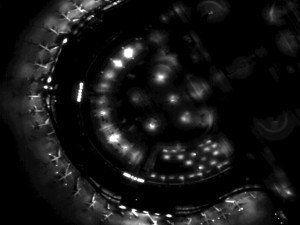
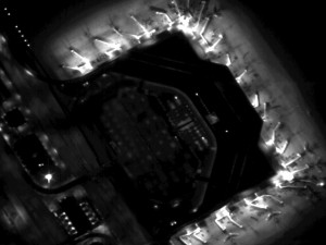 Previews of ~70-cm EROS B imagery collected during the night over Dallas-Fort Worth Airport on September 14, 2008. (Images Courtesy: ImageSat International)
