
Have you checked out the new and improved Image Hunter yet?!?! If not, you should!
Listening to the feedback we received on improving imagery search engines, the new version of Image Hunter features a major overhaul to the user interface as well as to the backend architecture. Image Hunter Version 2 is built on open-source technology so now it works on all computers, not just on Windows machines. We slimmed down the user interface to make it easier to find the imagery filters and other available tools. All things said, we really think you will enjoy your browsing experience with Image Hunter (Version 2).
Key February 2015 Improvements
During February, we are happy to announce that we unveiled a new and improved user interface for Image Hunter. A few of the key changes include:
- Automatic archive searches once a polygon is created.
- New filter options in the search results window including for date range.
- When users enter a search location in the gazetteer, an appropriate sized polygon is automatically created.
- A new feature that lets users edit vertices and shift polygon location.
If you find any bugs while using the new Image Hunter interface, we would be happy to hear about them!
Image Hunter can be accessed 24 hours a day, 7 days a week and is a one-stop shop for every major source of medium and high-resolution satellite imagery on the market today, including:

- WorldView-3
- WorldView-2
- WorldView-1
- QuickBird
- GeoEye-1
- IKONOS
- EROS B
- KOMPSAT 3
- KOMPSAT 2
- The Pléiades 1 constellation
- The entire SPOT constellation
- RapidEye
If any of our readers have struggled with other geospatial search engines that are clunky, only query one data source and/or do not provide image previews, then Image Hunter is the solution to your woes, as it features:
- Online browsing of satellite imagery from 4 data providers and 19 satellites.
- Near-instantaneous loading of low resolution preview imagery with collection date, cloud cover and other key metadata.
- The ability to define your area of interest by address and with coordinates, geometric shape or shapefile/KMZ.
- A responsive basemap with street names to provide spatial context when discovering data as well as crowd-sourced updates for the most accurate map possible.
- Exports of the area of interest you create as well as the scenes you select in shapefile or KMZ format.
- Support for all operating systems, and not just our friends with Windows machines!
The new version of Image Hunter can be accessed here. We are excited to find out what you think about Version 2!
If you have any ideas and/or feedback to improve the new Image Hunter, please let us know at sales@apollomapping.com or (303) 993-3863.
June 2014 Monthly Update
As many of our regular readers know, we have been in an extended alpha and beta period for the GISrack since April. While we are identifying multiple bugs and have added more users to our beta test each month, we still have a good bit of work left to do. There is a chance that a completely open beta will start in July still but it is looking less likely now. We will keep our readers updated each month on the progress we have made with the GISrack in this regular feature.
The GISrack Features
While we have your attention, now is a great time to explain a bit about the GISrack. Some of you may have used other GIS cloud services in the past, and in many ways the GISrack will be similar to these. But the GISrack will distinguish itself in a variety of important manners. Here is a list of the key features that will be unique to the GISrack:
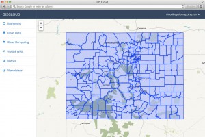
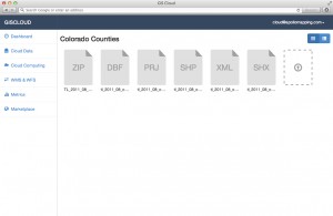
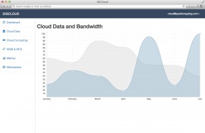
- Near-instant set-up–unlike other GIS clouds, the GISrack will take less than five minutes to sign up for, load data on to and get started using. No other cloud comes close to that flexibility.
- Tons of free spatial data–included with every subscription is access to more than 4 terabytes (TB) of free vector and raster data covering the United States and many parts of the world.
- A marketplace for spatial data – all users will have access to a library of spatial data that can be added to your GIS cloud. Further, users will be able to post data they have created to the marketplace to sell to other users (or let them use for free if you wish).
- Cloud computing – we will ask all users for feedback on the spatial operations they perform most frequently and will then implement the most popular ones in the GISrack.
- Free entry-level subscriptions – users will be able to use the full-functionality of the GISrack with up to 25 megabytes (MB) of free storage and bandwidth. And once you pass this storage limit, subscriptions will start at just $5.00 per month!
- A robust online viewer–for those users in your organization lacking access to a GIS application, the GISrack will feature an online viewer that can be accessed from anywhere in the world as long as users have internet access.
- Enhanced browsing speeds – we will have all of your spatial data cached in multiple locations around the world so access times will be greatly reduced for international users.
- Flexible streaming architecture – administrators will be able to setup multiple WMS and WFS feeds that can be shared with the appropriate teams of data users. Each feed can be seeded with the datasets these users need access to.
- Industry-leading data redundancy – with 99.999999999% data redundancy, you can be assured that your data will not be lost once placed on the GISrack.
Do you have any specific questions you would like answered about the GISrack? Or perhaps you want to join the beta program? If so, let us know by email at sales@apollomapping.com.
Last month we last visited Oxford, Mississippi, home to the University of Mississippi, better known as Ole Miss. The Small World format of linking places has changed, as the three of you who read this know, and so now we’re linking together schools by some random fact or shared trait. Well, Ole Miss was both a space grant and a sea grant institution, the former comprised of institutions that study outer-space related topics, and the latter being, well, you guessed it, folks that study the conservation of our most vital resource–water. For March, we decided to skip way across the country and leave the mainland on this trip through our Small World to the Aloha State, and the most recent to join our country (in 1959). Specifically, we are visiting the University of Hawaii at Manoa, the flagship campus of the UH system.
 Diamond Head, or as it is known by locals, Le’ ahi, is a volcanic tuff cone on Oahu that is a major draw for tourists. Situated near Waikiki, it is the symbolic backdrop for the state, and probably many Beach Boys’ songs. 40-cm color image captured by WorldView-3 (WV-3) on November 12, 2014 and comes courtesy of DigitalGlobe. Photo enhanced by Apollo Mapping.
The Sea Grant College Program started in 1966, and was modeled after the land grant system that was initiated through the 1862 Morrill Land Grant Act. UH Manoa was actually founded as a land grant college in 1907, while the sea grant program came to fruition in 1968, just two years after the national program was signed into action by President Johnson. There are only 32 sea grant programs in the United States, and the simple fact that Hawaii is the only state completely surrounded by water makes it a logical pick for the study of our water systems. As there are eight “main islands” (not to mention hundreds of smaller ones), it follows that water is a vital part of the region’s daily life, and so the study and preservation of these resources is of utmost importance. Hawaii’s ocean coastline covers some 750 miles, putting it just behind Alaska, California and Florida.
The UH Sea Grant has five main focus areas for its research agenda: sustainable coastal development, hazard resilience in coastal communities, sustainable coastal tourism, indigenous cultural heritage and water resource sustainability. Its hazard resilience efforts focus on beach restoration, erosion mitigation, sea level rise studies and tsunami research. While much of the emphasis in this correlate area is due to natural conditions such as climate change, it also works to counteract human-made issues such as population growth (Hawaii is the 13th most densely populated state, but the 8th smallest), the fishing industry, and of course, tourism, the state’s bread and butter. This gives heed to why the coastal tourism emphasis is so important. One aspect of this research, the Hanauma Bay Education program, serves over 1 million visitors a year and educates them on the fragility of coastal resources and the value of marine life.
 An overhead shot of civilization in paradise. Honolulu is the state capital and most populous city in the 50th state. It is quite likely that Thomas Magnum (of Magnum, P.I.) patrolled these streets keeping them safe from evil-doers in the 1980s. 40-cm color image captured by WV-3 on November 12, 2014 and comes courtesy of DigitalGlobe. Photo enhanced by Apollo Mapping.
In addition to its five focal areas, the UH Sea Grant has three centers of excellence: smart building and community design, sustainable coastal tourism and marine science education. The difference between the focal area model and the center of excellence model resides in the former being an educational and outreach program; while the latter is geared towards partnerships and in-depth research, which in turn informs the focal areas and thus community extension efforts. For instance, the centers of excellence program on sustainable coastal tourism partners with local hotels and resorts to distribute information about threatened or endangered species, which can drive tourist interest and knowledge in the topic, and then lead to a more informed public about the needs of our non-renewable or scarce resources.
The University of Hawaii at Manoa is set in paradise. Manoa resides on the island of Oahu, home to the capital city, Honolulu. With historical gems like Pearl Harbor, and natural gems like Diamond Head, the state is one of the crown jewels of our country for its beauty and abundant varieties of sea, land and air life. Hawaii is truly a remarkable place that is home to one of the pioneering universities in water conservation and water resource management.
Justin Harmon
Staff Writer
For those of you in need of ready-to-use, wide-area coverage mosaics, 5-meter natural color RapidEye Mosaics are a perfect fit. RapidEye Mosaics are virtually cloud-free and have been created with recent imagery collected during narrow time frames. With a 77-km wide footprint and five identical satellites in orbit, there is no better constellation to image huge areas in short times than RapidEye. These wide-area mosaics are competitively priced so ask your Apollo Mapping representative for a quote to support your next mapping project.
February 2015 Coverage Update
- These countries were added to the RapidEye mosaic database during February:
- Yemen
Here is a summary of the key features and product specifications for RapidEye Mosaics:
 A map of the off-the-shelf 5-meter RapidEye Mosaics (in green) that are available. Custom mosaics are available upon request.
RapidEye Mosaic Features
- Priced at less than $1.50 per square kilometer with a 500 sq km minimum order size
- Recent and virtually cloud free imagery (no more than 3%) collected in the most narrow time frame possible
- GIS-ready format
- Quick delivery as they are off-the-shelf mosaics
- Custom mosaics available if they are not offered now
RapidEye Mosaic Specifications
- Image Bands: True natural color mosaics created from raw red, green and blue spectral bands
- Resolution: 5-meters
- File Format: GeoTIFF with associated metadata files
- Bit Depth: 8-bit color balanced
- Projection/Datum: UTM WGS84
For more information about RapidEye Mosaics, you can reach an Apollo Mapping representative at (303) 993-3863 or at sales@apollomappping.com.
Are you looking for reasonably priced elevation data over northern Chile that is ready for delivery now?
If so, then we have the solution you have been looking for! Extracted from 50-cm stereo pairs collected by WorldView-1 and WorldView-2, DigitalGlobe released an impressive dataset covering more than 186,000 square kilometers (sq km) of northern Chile.
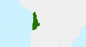 A map of the off-the-shelf 8-meter DSM coverage over northern Chile (in dark green).
Here are some specifics on the 8-meter elevation data offering over Chile:
- Geographic Region: northern Chile (see map here)
- Area Covered: 186,000+ sq km
- Resolution: 8-meter (m)
- Product Format: digital surface model (DSM), this region is sparsely populated and vegetated
- Absolute Vertical Accuracy: 8-meter Linear Error 90% (LE90%)
- Absolute Horizontal Accuracy: 10-m Circular Error 90% (CE90%)
For more information about the specific coverage we can offer and pricing of this 8-meter DSM, please contact the Apollo Mapping sales team at (303) 993-3863 or sales@apollomapping.com.

I was watching the HBO series Sonic Highways recently. It chronicles the history of music in eight great American cities, one of them being Austin, Texas, the self-proclaimed “Live Music Capital of the World.” One of the central figures in this documentary is the great Willie Nelson. A pioneering musician in the outlaw country movement of the 60’s, he is an American icon and treasure, and is still going strong in his 80s. Willie is known for a lot of things, one of which being his forward thinking on environmental and food issues. I first heard about him when I was a wee sprite back in 1985 and the very first Farm Aid was held in my hometown of Urbana-Champaign, Illinois. The mega-concert was orchestrated by Willie, John Mellencamp and Neil Young, and hosted numerous other big name attractions. Its intent was to raise money for farmers in danger of losing their property through mortgage debt.
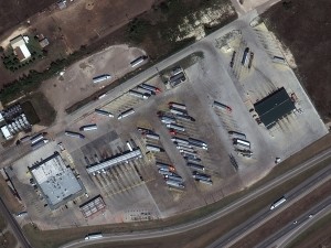 Carl’s Corner, Texas is home to one of two plants that give us BioWillie, the other being in Salem, Oregon. I guess it is the default fuel of every Willie Nelson tour as well; he probably gets a good discount! 40-cm color image captured by WorldView-3 on October 15, 2014 and comes courtesy of DigitalGlobe. Photo enhanced by Apollo Mapping.
Well, Willie isn’t a one-trick pony, and he kept fighting the good fight, spreading the word about the need for our country to pay attention to what we’re doing to it through destructive practices, one of which being excessive fossil fuel use. In 2004, his wife bought a diesel car that she used only biodiesel to run. Biodiesels are comprised of either vegetable or animal-fat bases and can be run in any car that comes stock diesel ready. The history of biofuel way predates Willie, however. The first known use of vegetable oil as fuel happened in the mid-19th Century, four decades before the first diesel engine. In the 1930’s, a professor at the University of Brussels applied for a patent for the use of vegetable oils as fuel, and the technology started to pick up steam. While the use of this alternative fuel continued throughout the early part of the 20th Century, it wasn’t until late in the 1970’s that it became more widespread. The 1990’s saw much of Europe building plants that rely on the derivatives of rapeseed oil.
Biodiesel isn’t the only alternative fuel on the market these days. Another that has become more prevalent is E85, an abbreviation for an 85% ethanol fuel blend derived from corn, making it most popular in the Midwestern states that are the largest producers of the crop. E85 is touted for its reduced tailpipe emissions, as well as its ability to be sourced locally, therefore mitigating the carbon footprint that accompanies long-haul transportation of traditional fuels. But E85 has its critics. Some say that the use of corn as fuel drives up world food prices, though advocates of the fuel source say that most corn is not intended for human consumption. Other arguments include the use of traditional fuels in the production of ethanol, thus making attempts at production of a “cleaner” fuel not necessarily so.
And while we still have miles to go (pun intended) on finding better options for fueling our cars more efficiently, and thus reducing the impact on the environment (such as electric cars), it bodes well for the future that scientists and engineers are pushing the boundaries of thought. It appears BioWillie is here to stay, for now. In 2012, Pacific Biodiesel put a BioWillie pump in Maui, where Willie happens to reside. His fuel is still mass produced in two states, Oregon and Texas, so there is hope that the brand will stay ‘on the road again’ and again, and again…
Justin Harmon
Staff Writer
From the West Coast of the United States, we travel to the other side of our great nation and down to the tip of Florida for this stop on the Pléiades 1 Golf Course of the Month. Our destination in Florida is Trump National Doral Golf Club located in Doral, next to the bustling metropolis of Miami, and site of the World Golf Championships–Cadillac Championships (WGCCC) from March 4 to 8, 2015. Started in 1999, the WGCCC once rotated between courses in the US and Europe; and in 2007, the TPC Blue Monster course at Trump National Doral became its ‘permanent’ home. The tournament is one of four World Golf Championships held in the year with a qualifying field of approximately 70 golfers. As the field is about half the size of a normal PGA event, there is no cut after the second round. The winner of the event receives $1.53 million from the $9 million purse as well as 550 FedEx Cup points. TICKETS Fore CHARITY, The First Tee and Make-A-Wish Foundation are among the WGCCC’s charity organizations.
Formerly known as Doral Country Club, the course was opened in 1962 by Alfred Kaskel, a real estate pioneer, and was originally designed by Dick Wilson. In 2012, Donald Trump purchased the bankrupt course for $150 million and shortly thereafter started a $250-million massive renovation of the golf club’s various courses with the help of renowned architect, Gil Hanse. Renovations were completed on the Blue Monster in 2014 with changes to every single green as well as to many fairways and more. In most cases, the holes were lengthened; and ponds and streams were added to 8 holes for a total of 14 with water hazards. The renovation also added more than 5,000 trees to the landscape of Trump National Doral. The Blue Monster plays 7,608 yards for tournaments with deep Bermuda grass roughs. The longest hole is the Par 5 10th, playing 608 yards (though that is not the tournament length which does not appear to be listed anywhere currently); and the shortest is the 153 yard, Par 3 15th hole.
 A 50-cm color image of the majority of Trump National Doral Golf Club collected on January 10, 2015 by Pléiades 1B. To see this course in 1.5-meter resolution, check out this month’s feature on SPOTMaps. Image photo enhanced by Apollo Mapping. © CNES 2012, Distribution Airbus Defense and Space / Spot Image S.A., France, all rights reserved.
Tiger Woods has won the event a record seven times with last year’s winner, Patrick Reed, beating the field by a single stroke. Only time will tell who the winner will be this year, and so, in the meantime, enjoy these 50-cm Pléiades 1 views of the golf course.
The Pléiades 1 High-Resolution Satellite Constellation
The Pléiades 1 constellation (or at least part of it!) has been in orbit since December 2011 and if you have not had a chance to check out any sample imagery, take a few moments and have a look at the gallery on our website. If you work with high resolution imagery, you should consider Pléiades 1 for your next geospatial project.
A variety of Pléiades 1 products are available from both a growing archive and as a new collection, including 50-centimeter (cm) pansharpened imagery and 50-cm panchromatic–2-meter (m) 4-band multispectral bundles. We are happy to discuss the technical specifications, pricing and tasking options available with this satellite constellation.
Working with Pléiades 1 since the launch of the first twin satellite, P1A, we have noticed that:
- Airbus Defense and Space is able to deliver on their tasking feasibilities.
The Apollo Mapping sales team can answer any questions you might have about the high resolution satellite constellation, Pléiades 1. We can be reached anytime at (303) 993-3863 or sales@apollomapping.com.
More sample images and technical information about Pléiades 1A and 1B can be found on our website here.