
For three years, Airbus’ twin high-resolution radar satellites, TerraSar-X and TanDEM-X, imaged the entire land surface of our planet multiple times to create the first ever global 12-meter (m) elevation model. Referred to as WorldDEMTM, this data is ideal for all mapping projects requiring accurate elevation models including orthorectification, floodplain determination, mineral exploration and hydrocarbon development.
WorldDEM June 2015 Product Updates

A coverage map of the one-degree cells that are currently available for delivery. Areas that are available will take a minimum of 10 days to deliver.
We are very excited to announce that sales of the bare earth version of WorldDEM, referred to as WorldDEM DTM, have commenced! Any area that is ready to order can now be produced in all three WorldDEM formats–see below for more technical details on these formats.
During June, sections of Russia and Southeast Asia were made available. WorldDEM areas that are available to order take a minimum of 10 days to deliver.
To date, there is more than 113,184,000 square kilometers (sq km) of WorldDEM data that is available! And some 2,507,000 sq km of WorldDEM was made available for delivery in the past month alone.
WorldDEM Specifications
The key product specifications of Airbus’ WorldDEM are as follows:
- Resolution: 12-m
- Coverage: entire landmass of the Earth, ~150 million square kilometers (sq km)
- Absolute Vertical Accuracy: < 4-m Linear Error 90% (LE90)
- Relative Vertical Accuracy: < 2-m LE90 (slopes ≤ 20%), < 4-m LE90 (slopes > 20%)
- Absolute Horizontal Accuracy: < 10-m Circular Error 90% (CE90)
- Vintage: all data collected within 3 years
- Source: interferometry from synthetic aperture radar (SAR) satellites TerraSAR-X & TanDEM-X
- Minimum Order: 500 sq km per polygon
- File Format: GeoTIFF
- Projection: geographic WGS84 (EGM2008, vertical datum), meter vertical unit
- Product Line Options:
- WorldDEMcore–unedited digital surface model (DSM), includes spikes, wells and voids
- WorldDEM–a DSM with removal of artifacts and water body flattening
- WorldDEM DTM–artifacts and surface features removed, i.e. a digital terrain model (DTM)
WorldDEM Coverage and Pricing
WorldDEM data has a 500 sq km minimum order size with a 10-km width requirement. Prices for two of the product lines have been set:
- WorldDEMcore–$10.80 per sq km
- WorldDEM–$13.50 per sq km
- WorldDEM DTM–$27 per sq km
WorldDEM Samples

A comparison of 30-m SRTM and 12-m WorldDEM elevation data over Arkansas, USA.
You can download four 12-m WorldDEM samples here, including one of the WorldDEM DTM product:
- Rapid City, South Dakota, USA–moderate to hilly terrain; elevations from 927 m to 1,765 m provided in two formats, WorldDEM and WorldDEM DTM
- Wagga Wagga, Australia–forest and urban with many water bodies; 137 m to 922 m provided in two formats, WorldDEMcore and WorldDEM
For more information about 12-m WorldDEM data, please send us an email at sales@apollomapping.com or check our website here.
In this monthly feature, we span the globe to examine Our Changing Landscape with time series of medium resolution RapidEye satellite imagery. The RapidEye archive dates back to late 2008 and already contains more than 5 billion square kilometers of data. This month, we look back at the tragedy that is the Syrian Civil War with an update on the bombing of Aleppo that we covered in our November 2012 edition.
The RapidEye Constellation

Click on the image above to see an animation of 5-meter natural color RapidEye imagery collected over the Aleppo, Syria area on August 19, 2012 (the last image in our November 2012 article), September 2, 2013 and September 14, 2014. These images will look a bit strange as they are displayed in false color whereby we use the green, red and NIR bands to create a look on the landscape your eye could never see. In our 2012 article, we were rather convinced that you could see bomb damage in 5-meter RapidEye data. Now, however, we are not as convinced as many of the dots that we perceived as bomb damage then appear to blink in and out through the three years depicted here. We would expect the older bomb damage to heal over time but not to appear, disappear and then re-appear–we are disappointed by this conclusion as you might be. (Images Courtesy: RapidEye)
RapidEye is a constellation of five 5-meter medium resolution satellites each offering five spectral bands of information. The RapidEye constellation offers daily revisits to every location on the planet with a huge footprint that is 77-km wide. The data is priced competitively with a starting cost of $1.28 per square kilometer for all five spectral bands–academics do receive discounts. RapidEye adds a fifth band, the red edge, to the ‘traditional’ multispectral set of blue, green, red and near-infrared (NIR). The additional spectral data in the red edge band allows users to extract more useful land ‘information’ than can be from traditional 4-band imagery sources. When RapidEye imagery is ordered as a Level 3A Orthorectified product, images from multiple dates are extremely well registered, making it the ideal data source for Our Changing Landscape.
The Bombing in Aleppo, Syria Continues
Since our November 2012 article on the Syrian Civil War, very little has changed as the battle between the al-Assad government regime and the rebels rages on. In this short piece, our focus was on one of the regions with the heaviest fighting, that of Aleppo. And that will continue to be the focus on this updated look in on the conflict.
If you were to look through recent news stories on the conflict in Syria, you will find mentions nearly every day to deaths caused by, rebel, al-Assad and even US bombing in Aleppo:
- May 31, 2015–rebel shelling kills 8 to 12 in a government-held neighborhood
- May 30, 2015–regime barrel bombs kill at least 85 people in and around Aleppo
- May 21, 2015–US-led coalition airstrike kills 15 al-Nusra militants
Similarly, since our November 2012 piece, the use of satellite imagery to identify bombing in Syria has continued, for example in these three pieces:
- September 19, 2014–high resolution imagery shows that five of Syria’s six UNESCO sites have been damaged
- April 29, 2014–Human Rights Watch identifies at least 85 bomb sites in Aleppo just since February 22nd when a UN “ban” was put on their use
- August 7, 2013–Amnesty International uses before and after images of Aleppo to show significant structural damage in Syria’s largest city
Now it is time to turn to the visual record created by multiple 5-meter RapidEye collections over Aleppo, Syria to see if there is evidence of this continued shelling of both rebel and regime positions.
If you would like to find out more about using RapidEye for your academic studies, engineering projects or any landscape analysis, let us know at sales@apollomapping.com or (303) 993-3863.
We download large imagery datasets from FTP sites on a daily basis here at Apollo Mapping so having a reliable FTP client is a must. It is possible to access FTP sites without an FTP client, but this method lacks stability and download speeds are often slower. An FTP client lets users connect to multiple FTP sites at once and to monitor download progress in real time.

Our favorite FTP client, by leaps and bounds, is the freeware program, FileZilla. Here are the features that really set it apart:
- You can download and/or upload up to 10 files at a time.
- There is a status tab which will show you if downloads fail.
- The bookmark function lets you favorite locations you commonly download to.
- There is a speed limit throttle so you can prevent FileZilla from taking all of your bandwidth while you are working on other items and downloading data at the same time.
Until my next edition of the Free For All, happy hunting for free geospatial goodies!
Brock Adam McCarty
Map Wizard
(720) 470-7988
brock@apollomapping.com
I never saw the Grateful Dead. I was a casual fan in high school, certainly not a Deadhead (which I claim you have to have seen the actual Dead to be an actual Deadhead), but a friend’s sister had an extra ticket to what turned out to be the final show in Chicago (I’m from Illinois). I asked my mom if I could go. She said “no” because I wasn’t responsible enough to handle the atmosphere–she was right (in fact, I don’t think I’m mature enough now some 20 years later)–and that I could go next time they were in town. How’d that turn out, mom? Well, during the period of self-discovery (and debauchery) that is college I became quite a fan of the Dead’s music. Over the years, I saw the remaining members in various formations as well as numerous cover bands seeking to channel their inner Dead. I listened to a lot of “live” shows of the Grateful Dead; I really was a fan.
Over the recent years, I haven’t listened to anywhere near as much of their music as I used to. I still enjoy it, and I still recognize their place in my life’s development, not to mention all the bands I like that they influenced. But I just don’t blast shows from 1977 like I used to. Then my mom–of all people–told me early last January that the remaining members were getting together for one last hurrah, celebrating their 50th anniversary. The shows were to be in Chicago at Soldier Field, the place where the “real” Dead took their final stand before Jerry Garcia passed away far too soon. At that moment I kind of knew I had to try and go.
The thing is that I knew tickets would be very hard to come by, especially if they were only to do 3 shows. All of the true Deadheads that are still alive, all the people that want to capitalize on the experience of the once-in-a-lifetime weekend and all of the hipster tools that are on board because it’ll be the place to be, well, that makes for a hard ticket to get–unless you’re willing to pay outrageously inflated prices from scalpers (seriously the worst part about free-market capitalism). I didn’t even try mail order because I didn’t want to tie up $1,000 that I knew would just be held in limbo sans interest. I did try public sale through that horrible ticketing company that more or less has a monopoly on sports and concert events, but I sat there for 45 minutes while the system “processed” my order only to check out because I knew nothing would come of it.

This is from my last credit card statement. The 4th line down signifies what would’ve been a darn good time.
Fortunately I had an ace up my sleeve: a friend of a friend works for a major music management company and has always been helpful in getting me tickets to sold out shows when I ask (which is few and far between because I don’t want to abuse his kindness). So back in January I put in my request for six tickets over three nights (2 per night). The thing is you never know if you’ll get them till a few weeks out; of the four times I’ve asked in the past though, I’ve been successful three times, so there were good odds.
Since that decision back in January I’ve lost a lot of interest in going though. It’s going to be a circus, and an expensive one at that. They’re aren’t exactly digging up Jerry’s bones so it isn’t going to be the Dead I cut my teeth on in my defining years. Most of my friends got shut out so that lessened my interest too. I had a fairly well-off friend get a box for the show on the 4th; $500 a pop (food and drink included), too rich for my blood. So I had started to hope that my request would get denied. If I did get them, I had to go.
Well, guess what? I got the tickets. Guess what again? Now I wanted to go (again). But guess what (final time I say that) now? I didn’t think I could. I’d be out of the state for some research in the weeks before, and then arriving back in Colorado the days before the shows. It’s not exactly cheap to fly on a holiday weekend, and I wasn’t interested in putting another 1,000 miles on the road after I would have just driven 2,500 roundtrip from Oregon and back. Add to that the fact that I’m trying to be less indulgent in my spending habits, and this wasn’t shaping up to be something that should happen. Boy, what a pickle.
The day I got the notification that the tickets had been secured, I made a call to a friend who was a tried-and-true Deadhead. She is in her early 60s and I knew she was going to Chicago for the festivities, but had not yet secured entry into the hootenanny. She was elated that I’d offer her these prized possessions (the tickets were in the “pit” just in front of the stage and fetching north of a $1,000 a piece online), and she knew the spirit of the Dead would come through for her in the end. This isn’t just some old hippie; she is in fact one of the first academics to write about the Dead and their fans in a scholarly manner. She needed to be there. She had been with the band from the early 80s on and it was only fitting that she be there for the last hurrah.
I know this is something that I’ll likely regret missing, but I can rest easily knowing that I let my friend (and one of her good buddies) get my tickets. For those not familiar with the subculture and ethos of the jamband circuit, this was as close to a “miracle” ticket (a freebie for a sold-out show) as you’ll come for this run of shows. I’ve always believed in karma (even though I believe in little else) and I’d like to think this will come back to me in some way. Although I’ve probably amounted a significant load of bad karma through my reckless ramblings in life, hopefully I can at least reset to zero with this one.
I told another friend that I was selling the tickets at face value; he was appalled. He told me I could make about $5,000 off my $1,300 investment. Yea, well, maybe. Probably. But that is against the spirit of this band for sure, and frankly, that is against the spirit of music in general. I understand supply and demand just fine; I try to invest wisely. I know what my education and experience should fetch me on the job market (that’s a whole other column. Geez….). But I just don’t believe in selling a ticket for more than I paid for it. What I do believe in is the power of music to bring people together, to help maintain and reinforce identity, and to shape a positive future. My dreams for this show may be Dead, but my spirit is still Truckin’ and my freak flag still flying. Peace, hippies.
Marco Esquandoles
Sausage King of Chicago (What movie is that from? Hmm?)
Every time we look at WorldView-3 (WV3) imagery, we are blown away. So we have decided to make this article a monthly feature for the viewing joy of our valued readers. For July, we feature three color 30-centimeter (cm) WV3 images collected over the hometown of our new employee (som): Kolkata, India.

Monthly Product Updates
Starting in June and lasting through the end of the year, DigitalGlobe is offering promotional pricing on archived and newly collected 30-cm WorldView-3 products! We are also accepting orders for 8-band multispectral plus 8-band shortwave infrared (SWIR) WorldVIew-3 data. Send us an email at sales@apollomapping.com to find out more.
WorldView-3 was launched in late 2014 and is the most advanced satellite the commercial marketplace has ever had access to. Here are a few of the features that really set it apart from the competition:
- Improved Resolution
- Higher resolution means you can see more detail in WV3 imagery.
- Data collected at nadir will have 31-centimeter (cm) panchromatic, 1.24-meter (m) visible and near infrared, 3.7-m shortwave infrared (SWIR) and 30-m CAVIS bands.
- At 20 degrees off-nadir, the resolution is 34-cm panchromatic, 1.38-m visible and near infrared and 4.1-m shortwave infrared.

This month we feature three unique 30-cm color WorldView-3 images of Kolkata, India. We say they are unique as Kolkata is a cloudy area so finding images this low in clouds and haze is quite lucky! Our personal favorite is the cricket stadium pictured here, it is called Eden Gardens; and according to Som (our new employee) who is from Kolkata, this is one of the best cricket stadiums in the entire world. These images have been photo enhanced by Apollo Mapping. (Images Courtesy: DigitalGlobe)
- Per US government regulation, all SWIR orders are produced at a maximum resolution of 7.5-m. CAVIS bands are not available for purchase at this time.
- Additional Spectral Bands
- If spectral analysis is part of your project, then no other satellite can match WV3 with its: 8 bands of visible and near-infrared data; and 8 shortwave infrared bands which are crucial for geological studies.
- Better Positional Accuracy
- With accuracies of 3.5-m CE90% or better (without ground control even!), WV3 has no rivals for its enhanced positional accuracy.
- Daily Revisits
- At 40 degrees latitude, WV3 will be able to image each location daily with 1-meter or better resolution and then every 4.5 days at 34-cm resolution or better.
- Increased Collection Capacity
- WV3 features a 13.1-km swath width (at nadir) with the ability to collect up to 680,000 square kilometer (sq km) of high-resolution data per day.
- Improved control movement gyros translate into larger maximum contiguous collection areas per pass, with up to ~7,500 sq km of mono imagery and ~3,000 sq km of stereo possible.
If you are interested in WorldView-3 imagery for your next project, please let us know by phone, 303-993-3863, or by email, sales@apollomapping.com.
You can also find more samples and technical information on our website here.

Have you checked out Image Hunter yet?
If not, you should! Listening to the feedback we received on improving current imagery search engines, Image Hunter features a friendly user interface with a backend architecture meant to maximize browsing efficiency. Image Hunter is built on open-source technology so it works on all computers, not just on Windows machines.
All things said, we really think you will enjoy your browsing experience with Image Hunter.
Key June 2015 Improvements
We are days away from launching our new feature, Data Alert–in fact, by the time this newsletter goes to print, it may very well be live! Data Alert will let users define a specific geography, a date range and the resolution required for their project. With this information, we will check the database every day for new imagery that meets this criteria and email you if we find a match. Work made simple; that is how we do it here at Apollo Mapping!
Image Hunter can be accessed 24 hours a day, 7 days a week and is a one-stop shop for every major source of medium and high-resolution satellite imagery on the market today, including:
- WorldView-3
- WorldView-2
- WorldView-1
- QuickBird
- GeoEye-1
- IKONOS
- EROS B
- KOMPSAT 3
- KOMPSAT 2
- The Pléiades 1 constellation
- The entire SPOT constellation
- RapidEye
If any of our readers have struggled with other geospatial search engines that are clunky, only query one data source and/or do not provide image previews, then Image Hunter is the solution to your woes, as it features:
- Online browsing of satellite imagery from 4 data providers and 19 satellites.
- Near-instantaneous loading of low resolution preview imagery with collection date, cloud cover and other key metadata.
- The ability to define your area of interest by address and with coordinates, geometric shape or shapefile/KMZ.
- A responsive basemap with street names to provide spatial context when discovering data as well as crowd-sourced updates for the most accurate map possible.
- Exports of the area of interest you create as well as the scenes you select in shapefile or KMZ format.
- Support for all operating systems, and not just our friends with Windows machines!
Image Hunter can be accessed here. We are excited to find out what you think about our industry-leading imagery search engine!
If you have any ideas and/or feedback to improve the new Image Hunter, please let us know at sales@apollomapping.com or (303) 993-3863.

An 80-cm IKONOS image collected over Rome, Italy on February 24, 2011. This image has been photo enhanced by Apollo Mapping. (Image Credit: DigitalGlobe)
For those of our readers who have been waiting to place orders for archived 80-cm IKONOS data, this update is for you! We had hoped that sales of IKONOS would restart in June but it looks like the production system upgrade is taking longer than expected. It appears that sales will now restart in Quarter 3 or Quarter 4 of 2015.
If you have any questions about this topic, feel free to email us at sales@apollomapping.com.
For those of you in need of ready-to-use, wide-area coverage mosaics, 5-meter natural color RapidEye Mosaics are a perfect fit. RapidEye Mosaics are virtually cloud-free and have been created with recent imagery collected during narrow time frames. With a 77-km wide footprint and five identical satellites in orbit, there is no better constellation to image huge areas in short times than RapidEye. These wide-area mosaics are competitively priced so ask your Apollo Mapping representative for a quote to support your next mapping project.
June 2015 Coverage Update
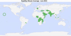
A map of the off-the-shelf 5-meter RapidEye Mosaics (in green) that are available. Custom mosaics are available upon request.
- These countries were added to the RapidEye mosaic database during June:
- Bahrain
- Kuwait
- Laos
- Qatar
- Saudi Arabia
- United Arab Emirates
- Also, as a note to our readers, the coverage for India is not complete but it does cover the northern third of the country.
Here is a summary of the key features and product specifications for RapidEye Mosaics:
RapidEye Mosaic Features
- Priced at less than $1.50 per square kilometer with a 500 sq km minimum order size
- Recent and virtually cloud free imagery (no more than 3%) collected in the most narrow time frame possible
- GIS-ready format
- Quick delivery as they are off-the-shelf mosaics
- Custom mosaics available if they are not offered now
RapidEye Mosaic Specifications
- Image Bands: True natural color mosaics created from raw red, green and blue spectral bands
- Resolution: 5-meters
- File Format: GeoTIFF with associated metadata files
- Bit Depth: 8-bit color balanced
- Projection/Datum: UTM WGS84
For more information about RapidEye Mosaics, you can reach an Apollo Mapping representative at (303) 993-3863 or at sales@apollomappping.com.