

Have you checked out Image Hunter yet? If not, you should!
Listening to the feedback we received on improving current imagery search engines, Image Hunter features a friendly user interface with a backend architecture meant to maximize browsing efficiency. Image Hunter is built on open-source technology so it works on all computers, not just on Windows machines. All things said, we really think you will enjoy your browsing experience with Image Hunter
Key July 2015 Improvements
The future is now! We launched our highly anticipated Data Alert service in mid-July and it’s a hit! We already have more than 50 project areas that are being searched daily for new imagery.
Data Alert lets you define an area of interest anywhere around the globe, the resolution your project requires and the number of months we should keep the alert active. Once this is set up, we check for new data over your area of interest every single day, and send you an email alert when we find coverage that meets your specifications.
Image Hunter can be accessed 24 hours a day, 7 days a week and is a one-stop shop for every major source of medium and high-resolution satellite imagery on the market today, including:
- WorldView-3
- WorldView-2
- WorldView-1
- QuickBird
- GeoEye-1
- IKONOS
- EROS B
- KOMPSAT 3
- KOMPSAT 2
- The Pléiades 1 constellation
- The entire SPOT constellation
- RapidEye
If any of our readers have struggled with other geospatial search engines that are clunky, only query one data source and/or do not provide image previews, then Image Hunter is the solution to your woes, as it features:
- Online browsing of satellite imagery from 4 data providers and 19 satellites.
- Near-instantaneous loading of low resolution preview imagery with collection date, cloud cover and other key metadata.
- The ability to define your area of interest by address and with coordinates, geometric shape or shapefile/KMZ.
- A responsive basemap with street names to provide spatial context when discovering data as well as crowd-sourced updates for the most accurate map possible.
- Exports of the area of interest you create as well as the scenes you select in shapefile or KMZ format.
- Support for all operating systems, and not just our friends with Windows machines!
Image Hunter can be accessed here. We are excited to find out what you think about our industry-leading imagery search engine!
If you have any ideas and/or feedback to improve the new Image Hunter, please let us know at sales@apollomapping.com or (303) 993-3863.
- From our focus on the very cool super-material, graphene, this month I turn my attention to innovations in wind power technology.
First, here are a few ways to improve the efficiency of current wind turbine designs. This idea improves wind turbine efficiency by placing a second, smaller set of blades on the structure; while this idea improves efficiency with an active real-time monitoring system that makes tweaks to the position and more of turbine blades. GE thinks that adding a dome to the front of a wind turbine rotor can improve its efficiency.
One of the biggest expenses to constructing a wind turbine are the rare earth elements used in the magnetic direct-drive power systems. Researchers at Virginia Commonwealth University believe that nanoparticles of iron, carbon and cobalt could provide a low-cost alternative; while USDOE researchers have synthesized a low-cost alloy of neodymium, iron, boron, cerium and cobalt which could be substituted for magnetic rare earth elements.
Finally, here are three research topics which focus on the interaction of wind turbines and the nature that surrounds them. It appears that grassland birds abandon their mating grounds when they are in close proximity to wind turbines. This windless turbine could save the lives of many airborne insects and birds. And could painting wind turbine blades purple help to reduce wildlife deaths?
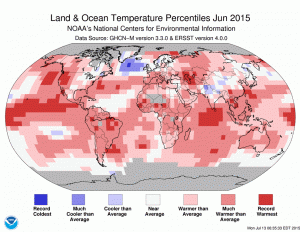
The June 2015 temperature departure from average map. You can see significant warmth spread across the entire globe with temperature records set on every continent other than Australia. The only notable area cooler than average was over northern India and Nepal. (Map Credit: NOAA)
- The June 2015 NOAA Global Climate Report is out and I am beginning to sound like a broken record as the combined land and water temperature for the month was the highest in the 136-year record. The twelve month period from July 2014 to June 2015 was also the hottest ever on record, with temperatures 1.49 degrees Fahrenheit above average. This record surpasses that set last month for a 12-month period by just one one-hundredth of a degree Fahrenheit.
- On August 16, 1777, American forces pushed back the Red Coats in the Battle of Bennington during the Revolutionary War, and in honor of this feat, my Google Search this month was, “GIS and Battle of Bennington”. If you scroll through the results, you might find this news story about a National Park Service grant to preserve various battlefields across the USA, including $80,000 to develop a GIS database of the Battle of Bennington.
- From the East Coast, we head south to the coastal state of North Carolina for a review of their largest city’s online GIS resources, Charlotte. And wow, I have to say that the Charlotte (combined with the County of Mecklenburg) GIS site is amazing, it covers all the aspects one might expect. First, there is a very easy to use online map with a huge array of layers that can be toggled on and off. For advanced GIS users, you can download source spatial files from this site. There is a nice list of additional online GIS resources for the region; and finally, they even support custom map requests. Nice job Charlotte!
Brock Adam McCarty
Map Wizard
(720) 470-7988
brock@apollomapping.com

A 50-cm color image of Busch Stadium, St. Louis, Missouri, USA collected on June 9, 2014 by Pléiades 1B. To see this stadium in SPOT 6/7 1.5-meter resolution check out this month’s feature on SPOTMaps. Image photo enhanced by Apollo Mapping. © CNES 2015, Distribution Airbus Defense and Space / Spot Image S.A., France, all rights reserved.
In August, we travel from Europe back to the United States with a look at Busch Stadium in St. Louis, Missouri during the height of the baseball season for this stop on the Pléiades 1 Stadium of the Month.
Name & Its Origin: On February 20, 1953, the sale of the St. Louis Cardinals baseball team to the Anheuser-Busch, Inc. corporation was announced. And following the 1953 season, Sportsman’s Park was renamed Busch Stadium. The current Busch Stadium (sometimes called New Busch Stadium) is actually the third version of the ballpark; with the first one played in through the 1965 season, and the second version through the 2005 season.
Location: Busch Stadium is one of downtown St. Louis’ most iconic structures, located less than a half mile from The Gateway Arch. The stadium is located just feet from the west bank of the Mississippi River at about 440 feet above sea level.
Stadium Capacity/Size, Architect & Build Date: The Hunt Construction Group and its affiliates began excavation on Busch Stadium’s site on September 27, 2003, and its doors officially opened on Monday, April 10, 2006 for the Cardinal’s first home game of the season. Some 2,800 workers poured 2.2 million hours into the project, constructing one of baseball’s iconic stadiums with a capacity for 46,844 screaming ‘Cards’ fans when opened. In 2014, Ballpark Village was added with 300 more rooftop seats 500-feet away from left-center field. For more mind-numbing facts about Busch Stadium, check out this website.
Type of Field Surface: There is 140,314 square feet of playing field at Busch Stadium. It is covered with lush green Kentucky Bluegrass from a sod farm located in Fort Morgan, Colorado and owned by Graff’s Turf.
Key Sports Teams: Busch Stadium is all about baseball as it is owned by the only sports team who plays in the venue, the St. Louis Cardinals.
Most Popular Yearly Event: From what I can tell, the new Busch Stadium has been used exclusively for baseball games. The older Busch Stadiums hosted several concerts and even football games so who is to say if the current edition will never follow suit. Either way, the Cardinals remain one of baseball’s most popular (and successful) teams, with an average attendance over 43,000 (or 98% of capacity) through the 2015 season so far.
Fun Factoids: (1) In one season of baseball games, there are 540,000 hot dogs, 181,000 pounds of nachos and 32,000 gallons of nacho cheese sold at Busch Stadium. (2) And during that same season, some 7,315,200 feet of paper towels and 15,373,800 feet of toilet paper is used. (3) Since Busch Stadium opened in 2006, the Cardinals have reduced energy use by 20% and waste by 10%. Further, the “A Greener Game Program” has recycled more than 2,500 tons of solid, yard and organic waste since 2008. (4) Having statistics on the amount of building material used in Busch Stadium is just awesome, as 620,000 bricks were laid by hand; 520,000 pounds of HVAC sheet metal was installed; 85,000 feet of pipes were fitted; 29,787 gallons of paint was applied; and 914 doors were hung during its construction.
The Pléiades 1 High-Resolution Satellite Constellation
The Pléiades 1 constellation (or at least part of it!) has been in orbit since December 2011 and if you have not had a chance to check out any sample imagery, take a few moments and have a look at the gallery on our website. If you work with high resolution imagery, you should consider Pléiades 1 for your next geospatial project.
A variety of Pléiades 1 products are available from both a growing archive and as a new collection, including 50-centimeter (cm) pansharpened imagery and 50-cm panchromatic–2-meter (m) 4-band multispectral bundles. We are happy to discuss the technical specifications, pricing and tasking options available with this satellite constellation.
Working with Pléiades 1 since the launch of the first twin satellite, P1A, we have noticed that:
- Airbus Defense and Space is able to deliver on their tasking feasibilities.
The Apollo Mapping sales team can answer any questions you might have about the high resolution satellite constellation, Pléiades 1. We can be reached anytime at (303) 993-3863 or sales@apollomapping.com.
More sample images and technical information about Pléiades 1A and 1B can be found on our website here.

In the coming months, Apollo Mapping will be unveiling the industry’s most affordable, scalable and secure spatial cloud, the GISrack. While we are busy building out the infrastructure and technology required to support the most flexible GIS cloud on the market, now is a great time to explain a bit about the GISrack.
Some of you may have used other GIS cloud services in the past, and in many ways the GISrack will be similar to these. But the GISrack will distinguish itself in a variety of important manners. Here is a list of the key features that will be unique to the GISrack:

- Near-instant set-up–unlike other GIS clouds, the GISrack will take less than five minutes to sign up for, load data on to and get started using. No other cloud comes close to that flexibility.
- Tons of free spatial data–included with every subscription is access to more than 4 terabytes (TB) of free vector and raster data covering the United States and many parts of the world.
- A marketplace for spatial data – all users will have access to a library of spatial data that can be added to your GIS cloud.
 Further, users will be able to post data they have created to the marketplace to sell to other users (or let them use for free if you wish).
- Cloud computing – we will ask all users for feedback on the spatial operations they perform most frequently and will then implement the most popular ones in the GISrack.
- Free entry-level subscriptions – users will be able to use the full-functionality of the GISrack with up to 25 megabytes (MB) of free storage and bandwidth. And once you pass this storage limit, subscriptions will start at just $5.00 per month!
- A robust online viewer–for those users in your organization lacking access to a GIS application, the GISrack will feature an online viewer that can be accessed from anywhere in the world as long as users have internet access.
- Enhanced browsing speeds – we will have all of your spatial data cached in multiple locations around the world so access times will be greatly reduced for international users.
- Flexible streaming architecture – administrators will be able to setup multiple WMS and WFS feeds that can be shared with the appropriate teams of data users. Each feed can be seeded with the datasets these users need access to.
- Industry-leading data redundancy – with 99.999999999% data redundancy, you can be assured that your data will not be lost once placed on the GISrack.
Do you have any specific questions you would like answered about the GISrack? Or perhaps you want to join the beta program? If so, let us know by email at sales@apollomapping.com .
Are you looking for reasonably priced elevation data over northern Chile that is ready for delivery now?

A map of the off-the-shelf 8-meter DSM coverage over northern Chile (in dark green).
If so, then we have the solution you have been looking for! Extracted from 50-cm stereo pairs collected by WorldView-1 and WorldView-2, DigitalGlobe recently released an impressive dataset covering more than 175,000 square kilometers (sq km) of northern Chile.
Here are some specifics on the 8-meter elevation data offering over Chile:
- Geographic Region: northern Chile (see map here)
- Area Covered: 186,000+ sq km
- Resolution: 8-meter (m)
- Product Format: digital surface model (DSM), this region is sparsely populated and vegetated
- Absolute Vertical Accuracy: 8-meter Linear Error 90% (LE90%)
- Absolute Horizontal Accuracy: 10-m Circular Error 90% (CE90%)
For more information about the specific coverage we can offer and pricing of this 8-meter DSM, please contact the Apollo Mapping sales team at (303) 993-3863 or sales@apollomapping.com .
In this monthly article, we provide details on updates to Airbus Defense and Space GEO’s SPOTMaps product. SPOTMaps is an orthorectified 2.5-meter (m) and now 1.5-m natural color imagery layer with coverage over more than 110 countries–totaling an impressive 135 million plus square kilometers (sq km). For projects requiring a value-priced basemap better than what 15-m Landsat can offer, there is no other choice than SPOTMaps.

1.5-meter SPOT 6 natural color images collected over Great Strahov Stadium in the city of Prague, Czech and the surrounding areas on April 19, 2015. If you would like to see this stadium in Pléiades 1 50-cm (and even collected on the same date) resolution as a comparison, please click here. © CNES 2015, Distribution Airbus Defense and Space / Spot Image S.A., France, all rights reserved.

1.5-meter SPOT 6 natural color images collected over Great Strahov Stadium in the city of Prague, Czech and the surrounding areas on April 19, 2015. If you would like to see this stadium in Pléiades 1 50-cm resolution (and even collected on the same date) as a comparison, please click here. © CNES 2012, Distribution Airbus Defense and Space / Spot Image S.A., France, all rights reserved
SPOTMaps Product Updates – June 2015
- To date, more than 23,651,000 sq km of SPOTMaps1.5 data have been released with some 485,000 sq km in the past month alone.
- These countries are currently in production and will be added to the SPOTMaps1.5 database soon or they will be updated:
- Australia (part of the country)
- Central African Republic
- Mozambique
- Nigeria (part of the country)
- Ukraine
- Production of SPOTMaps2.5 is complete now that SPOTMaps1.5 are being released.
For those who have never worked with SPOTMaps, below is a summary of key product specifications of the 1.5-m and 2.5-m versions as well as product differentiators.

This map of SPOTMap1.5 coverage shows the regions that have been released as well as those currently in production. An Apollo Mapping representative can provide more details on the specific year ranges used in each mosaic.

This map of SPOTMap1.5 coverage shows the regions that have been released as well as those currently in production. An Apollo Mapping representative can provide more details on the specific year ranges used in each mosaic.
Key Product Specifications
- SPOTMaps1.5
- Resolution:5-m
- Spectral Bands: true natural color (RGB)
- Horizontal Accuracy: 6 to 10-m CE90 (circular error 90%)
- Projection/Datum: UTM WGS84
- Source Data: SPOT6/7 satellite imagery
- File Format: GeoTIFF
- SPOTMaps2.5
- Resolution:5-m
- Spectral Bands: simulated natural color (RGB)
- Horizontal Accuracy: 10 to 15-m RMSE (root mean square error)
- Projection/Datum: UTM WGS84
- Source Data: SPOT5 satellite imagery
- File Format: GeoTIFF
Product Differentiators
- Recent and ready for immediate delivery and integration with your GIS
- Seamless, orthorectified coverage across countries and entire regions in 1.5-m and 2.5-m resolution
- Suitable for work up to 1:10,000 scale
- Custom product framing with minimum orders of ~100 sq km
- Product series is updated nearly every month
- Source data can be delivered with all SPOTMaps mosaics
- Volume and academic discounts are offered
- Multi-user licenses are available
If you would like pricing details and/or additional product details,such as date ranges and accuracy specifications, please let us know at sales@apollomapping.com or (303) 993-3863.
Do you have the need for regularly updated images of locations around the world?
Perhaps you need imagery to integrate with an OEM solution you are developing?
Or maybe your organization uses large amounts of high-resolution imagery each year, and you are seeking a low-cost option for this data?
If you answered yes to any or all of these questions, then the solution you are looking for is DigitalGlobe Basemap (DGB).
With DigitalGlobe Basemap, you have access to millions of square kilometers of imagery with low cloud-cover and off-nadir angles. This data is accessible in streaming web-mapping services as well as through an online viewer. And perhaps the most important feature of DGB is the regular updates you can receive as out-dated imagery is often of little or no use to our valued clients.
June 2015 DigitalGlobe Basemap Product Update
While we refer often refer to DGB as one product for the sake of ease, it is actually a suite of products specialized for various basemap applications. One of these is called Basemap +Vivid (or +Vivid for short), which features high-resolution and low cloud cover full-country orthomosaics. To date, there are 95 countries available covering more than 50 million square kilometers! This product can be purchased as an online subscription service or as an offline GeoTIFF. During Q3 2015, the continent of Europe will be added to the +Vivid database, and then the United States will be added in Q4 2015.
DigitalGlobe Basemap Product Specifications

A coverage map showing available DigitalGlobe Basemap imagery over Russia by location and the most recent coverage date as of May 18, 2015. In many locations, there are multiple imagery dates available.
- Geographic Regions Covered: defined area of interest, US county, country or global
- Maximum Imagery Resolution: 50-centimeters through WMS and WCS; 60-cm for other delivery mechanisms
- Data Sources: primary = WorldView-2 and GeoEye-1; secondary = QuickBird, IKONOS, WorldView-1 and aerial
- Database Update Frequency: annual, semi-annual, quarterly or daily; updates are to limited portions of the database, not the entire database
- Data Accuracy:5-meter CE90%
- Database Access: OGC streaming services (i.e. WMS, WMST, WCS and WFS), Google Earth streaming services (i.e. EarthService), ArcGIS plugin (i.e. ImageConnect), offline database and online portal
- Pricing Model: transactional and unlimited tiered subscriptions based on geography and number of users (with uplifts for more frequent updates and imagery downloads)
- Subscription Term: annual
For more information on the pricing and coverage available in DigitalGlobe Basemap, you can reach our sales team anytime at sales@apollomappping.com or during typical business hours at (303) 993-3863.
We travel the world, keep to our own
Everyone stares into their drinks
And beautiful girls and men on their own
and nobody’s saying what they think
I’ve never been brave enough to ask them
I doubt I’ll find my courage now
Maybe I will and maybe I won’t
There’s bears that dance and bears that don’t
-Jerry Joseph, Bears that Dance
I remember I was traveling back from Alaska with a stopover in Seattle on one trip. Aside from the fact that flying is faster than driving anywhere, I really cannot stand to fly. I’m not scared, but I just feel that I’m out of control of everything; and nothing about it is convenient. Maybe one other redeeming value is that it is good for people watching; at least while you’re still in the airport. I had already boarded the plane and was sitting in an aisle seat in an unaccompanied row. I was secretly hoping nobody else would breach my space, so as the people shuffled by without looking my way, I was quite content. Then a very beautiful girl approached my aisle with a glowing smile. I asked her if this was her row. She said, “No,” but that she loved my hair. I’m an average looking guy with curious hair. Most of the time it is greeted as an oddity, occasionally it is fawned over. But never by beautiful girls. Her smile was simply electric, but alas, she passed.
Shortly into the flight, I got up to use the restroom, scanning the back rows for her. Was that just a fleeting, shared moment, or was there something more? I saw her, unfortunately sitting next to a guy that likely was her boyfriend, but her face lit up again with that beautiful smile. We didn’t make eye contact again until I stood up to leave the plane, and again once more in the terminal, where she was indeed with that guy. What is so important about this you might ask? In two words; wishful thinking.
This beautiful girl with a beautiful smile that loved my hair, well, I had seen our whole life unfold between us in a millisecond. I actually envisioned that this could be the love of my life. This would be the perfect story of how you meet the one you spend eternity with.
I had succumbed to an ephemeral crush. But just as soon as I had fallen in love without ever exchanging any real dialog or interaction, the moment passed. This wasn’t the first time this had happened to me, and it surely will not be the last. But what does it mean? Why does it happen time and again? Why does my brain (or my heart) allow for these moments of intense feelings and unrealistic expectations when the likelihood of the scenario actually coming to fruition is slim to none? But most importantly, can I benefit from these experiences by taking stock of them and their impact, if only fleeting, on my life?
I doubt it. I’m far too cynical. But sometimes I look around at people and wonder how they ended up together. I mean, I’ve seen some pretty strange connections out there. I’m always curious about how those fleeting moments were capitalized on by strangers; how much is serendipity and how much is gusto and courage? I had a friend a while back that was looking to get into a new relationship and he read somewhere that you should approach 100 women (or men) in a month to become comfortable with seizing those moments that we so often let slip. At the end of it, his ‘count’ was pretty good. He got about 25 numbers, ended up going out with about ten of them and marrying one. Now I’m not saying that these would all qualify as ephemeral crushes; in this instance, it was more an exercise in growing a pair. But I guess the desire to reach out to someone has to be founded in something, so maybe there are potential for connections with multiple people out there, not just the ones situated in animal attraction.
But let’s get back to what I want to talk about–the ephemeral crush. Every one of us has had that passing glance or smile to or from another (unless you’re really ugly, then sorry). And maybe that’s all it is, just a glance. But how do you know how to react in those situations? There’s the camp that will say to seize the moment, then there’s the camp that says not to invade people’s personal space; this camp is either libertarian or of the politically-correct ilk. But how do we make connections anymore when there are so many social rules?
I did this online dating thing for a month or two–that was weird–and I went out with a few girls and had some fun. I was talking to one about how hard it is for guys to approach girls and after all the social evolution that has occurred, it still falls on the guy to do the heavy lifting in that domain (or maybe I’m just one of those ugly guys I dissed a few sentences ago). I asked her if she went out with every guy that contacted her. She said “no” as there were so many (a bit of an ego on this one). I told her I thought if we were good people (male/female, ugly/attractive) we should go out with everyone who asked us (assuming we’re not in a relationship) because it takes so much effort and courage to ask someone on a date. She half-agreed because she knew that we shouldn’t be making snap judgments on appearance or a few stupid one-liners in an online profile. I don’t think either of us changed our strategy though.
I learned to approach women in college; always drunk and almost always after midnight. Now that I’ve grown older, I drink less and have little desire to be up that late too often. So I never learned how to recalibrate for the dating scene I’m in now. It’s as if I had to put the training wheels back on the bike after riding for more than a decade. A fish out of water as they say.
Nowadays, when I get that rare glance or smile, I think about opportunities that I’ve missed and consciously acknowledge the ones I’m not taking advantage of in the now. But at least I’m being reflective. Falling in love in the moment; what does it mean? These aren’t rational reactions, they’re purely from the heart (loins?). I guess they speak to desires I have for myself (both good and bad intentions) but why do I lack the mojo to act (without a social lubricant)? Perhaps the real education growing up in school would be to learn how to navigate social interactions and differences. But I guess there aren’t too many grade schoolers (hell, even high schoolers) that can handle psychology (maturity, emotions and hormones are too blame). And after re-watching the Sex in the City series, Carrie didn’t let me in on any tips about how to navigate these ephemeral moments. What good was that show?
So that leaves me with this parting thought: Maybe I’m reading too far into it. A pretty face with a pretty smile is just that. But if you (I) think there’s something hiding behind it, maybe you (I) should just act. What have you (I) got to lose? We try to save face too much in this culture. Perhaps we (I) should learn to have comfort in defeat, to learn a little humility if it doesn’t go as planned. After all, they say it will only make you stronger….
Marco Esquandoles
Professional Amateur