
I’ve lived around the country a bit, occupying all regions except the Northeast: the Midwest, the Southeast, Texas, the Rockies, the Southwest, the Northwest and the Mid-Atlantic. Some areas have been far more enjoyable than others, some I’d love to return to, some I’d just as much assume to forget. I have a little more freedom with work than many, so I can bounce around frequently, but I always find myself longing for a return to the Rockies. The Front Range of Colorado, however, no longer has much appeal for me; it’s simply too congested there. The same can be said about the “ski belt” along I-70; too many people in too small a space. Any semi-metropolitan pocket of Colorado is just too overrun, and I imagine the same is true about other prized areas in the Rockies; certainly Salt Lake City, and I imagine the same for Bozeman and Missoula, Montana, Coeur d’Alene, Idaho, and even the areas around Jackson, Wyoming and Driggs, Idaho. People are drawn to beautiful places, understandably, but they’re also drawn to convenience and luxury–and, of course, to other people. Having grown up in the Midwest, I have always been baffled by those who have no desire to roam, not even for a little while, to places more majestic than the cornfields and prairies; I guess it just boils down to comfort. Those who have never left their home, regardless of where that is, just lack a sense of adventure–or they have a sense of attachment. Maybe both.
Anyhow, I like to wander, and I consider myself quite nomadic–as evidenced by my many moves. But as I’ve gotten older, I have less of a desire to roam from place to place, and I’ve also accepted that I’ll probably stick with my job on the Eastern seaboard for the foreseeable future, thus keeping me from my beloved “stomping grounds” of the Rockies, at least on a permanent basis. But I do plan to return, even if just for chunks of time here and there. It’s expensive to travel, especially for long stretches of time, so I need to figure out how I can make two months out West every year a reality without breaking the bank or living hand to mouth. I don’t have an answer yet, so I’ll keep looking. Fortunately, at least for this summer, I got lucky–something I’m not used to getting, but am thankful for the opportunity either way.
A friend of mine in my adopted hometown has a brother who owns several properties in Colorado; he’s a property manager and thrives on the ski and summer travel seasons. Well, he moved out of the country, and while he’s still managing his properties, the pandemic, coupled with him being offsite, has resulted in there being some openings at some of his properties in Summit County. So, my friend, well, she knew how much I loved Colorado and how I return every summer for a week or two and she gave me an offer I couldn’t refuse: come stay for free in Colorado for six weeks. No catch, no cost, no work exchanged, nothing. Just come do whatever it is I want to do out in Colorado (which is largely hiking and being surrounded by natural beauty). Of course I said “yes.”
I am writing from the balcony of my 3,500 square foot house burrowed off the beaten path in Breckenridge, about a 20-minute walk to town. There is a trail literally outside my front door that, if it were the only one I got to hike on, I would be just fine with, but I’m within 15-40 minutes of some of the most beautiful hiking and scenery I could ask for. So, I hike every morning, I do a little work in the afternoon–ahh, the benefits of teleworking–and I read and hang out in the evening, all the while basking in the glory of the Rockies. I really can’t complain.
 Above is Quandary Peak, one of the legendary “14ers” of Colorado, just a stone’s throw down the road from my summer squat.
The only tricky thing, for me, is not ticking off my friend. It’s sort of hard to go from hanging out with someone maybe 3-4 times a month to living with them 24/7 for six weeks, but hey, I’m trying to keep that in the front of my mind at all times. She did not need to invite me, obviously, and certainly she could throw me out at any point if she wanted to as well–hopefully she doesn’t though. We’re a week into it, and so far she has confirmed that I have not annoyed her yet–though she has indicated that I’m a little “snarky” at times, but I’m quick to remind her that she knew that long before she invited me to come stay with her. My guess is she really wanted to do this (obviously, she’s here, isn’t she?), but that she knew she might get a little bored by herself, and she probably wanted the comfort and safety of having someone around, especially to hike with. Every morning we’re on the road by 7:30am, typically on the trail by 8am or so, and then back home by noon. We’ve got three dogs between us, so we’ve got quite the pack when we head out. It’s nice. It’s comfortable.
At the end of June we’ll depart; she’ll head back to the East Coast, I’ll stick around the Rockies a little bit longer, and I’m curious what it’ll be like to walk away from here again–and to walk away from living with her. Now, this is a strictly a platonic arrangement, just in case you were wondering, but even only a week into it, there is a little bit of a feel of a married couple in some ways (in a good way). That’s probably me reading into it, but I guess it’s just like I said: it’s comfortable. It also probably doesn’t hurt that, so far, I’m enjoying myself immensely just being this close to all of this splendid beauty. That doesn’t hurt at all.
Nonetheless, I don’t want to annoy her, certainly now when we’re sharing the same roof, but also for the future when we both return to our separate lives in the same town a few thousand miles away. Because of this, I’m trying to be conscious not to get in her way too much, give her space, take off on my own when I can, etc. I plan to travel to the Front Range to see some folks (yes, that’s you, Brock!), and I may dip down into the Southwest corner to see a friend who now lives in New Mexico (side note: he and I moved to Colorado years ago and he also used to work with Brock). She’s going to take a day trip or two to Aspen, so hopefully we’ll see just enough of each other to have fun and continue to appreciate one another as friends, but still make space so that we don’t feel like we’re constantly up in one another’s business. More so me than her.
It’s going to be awfully hard to head east in July. I really like my job, it’s the best one I’ve ever had, so there is no other option. But still I wonder: what if I could find something to do out here, even if not as ideal as what I’ve got now; would it be worth it to live in an area I love far more than the East Coast? Maybe. I’m sure that’s something I’ll continue to think about the entirety of my time out here, and certainly on that damn near 2,000-mile drive home. Driving through Kansas, Missouri, Illinois, Indiana, Ohio, etc. sure does make you long for prettier parts of the country.
Well, here I am; I’m going to enjoy it. I’ll try to work on that whole “being present” thing, for if for no other reason, this is the place where I’m most happy doing so.
Marco Esquandoles
The Colorado Kid

Here at Apollo Mapping, we want you to find the satellite imagery you need, even if that means finding free imagery using tools besides Image Hunter. In this Free For All edition, we will review several sources of free imagery, and while each download system is different, you must expect the data to be limited in various ways.
In some cases, experience with GIS is a determining factor in finding satellite imagery. To access the oldest and widest ranging catalog of imagery, the United States Geological Survey (USGS) created an online tool known as Earth Explorer. Not only must you sign up for an account to download imagery, it also requires knowledge of GIS platforms and geospatial data to use efficiently. To begin, there is a plethora of data to sort through, ranging from optical imagery to aerial, UAV, radar and digital elevation models (DEMs). To search, users can enter coordinates, addresses or geographic features, draw their own region of interest, or upload a KMZ/KML/shapefile. Results can be filtered by area, date, cloud cover and specific sensors. Earth Explorer now includes even more medium-resolution imagery as the Sentinel-2 archive from the European Space Agency (ESA) was added recently. Sentinel-2 data can also be accessed via the Copernicus Open Access Hub, which is a relatively straightforward webmap that filters and downloads imagery from any of the three Sentinel missions.

An additional platform I would recommend is NASA’s Earthdata Search. Earthdata Search is a great place to find… you got it, data about the Earth! Much of it comes from analyses done in Earth science projects by NASA, hailing from the Earth Observing System Data and Information System (EOSDIS) Distributed Active Archive Centers (DAACs). There is a plethora of land use and land cover data that is specifically satellite-derived, such as permafrost and forest types. Users can filter searches in a variety of ways, including by features, keywords, platforms, instruments, organizations and more. But, in order to view or save the data, you need to create an account.
If you are interested in checking out more near real-time satellite imagery or completely free-to-use software that contains imagery, try Google Earth or Bing Maps as well as this tool from NOAA and NASA’s Worldview.
Jake Zatz
Social Media Guru
 A 15-cm HxGN Content Program aerial image collected over Los Angeles International Airport (LAX). Check out that amazing detail!
While satellite imagery is our jam, for some projects it is admittedly not detailed enough. In these situations, when your polygon is over the United States or Europe, our 15 to 30-centimeter (cm) HxGN aerial imagery could be the ideal solution!
Searchable on Image Hunter and ready for delivery now, keep HxGN aerial imagery on your radar for your next geospatial project. As with our other datasets on Image Hunter, we feature daily updates of HxGN aerial imagery so you can be sure that you get the most up-to-date results every time you search with our system.
Here are the key specifications of the HxGN Content Program aerial imagery offering:
-
- Imagery Resolution – 15 to 30-cm (8-bit color and CIR layers provided)
- Geography Covered – Europe and the United States
- Positional Accuracy –07 to 2.6 meter Circular Error 90% (CE90%)
- Minimum Sun Angle – 30 degrees
- Cloud Cover – basically 0%, we challenge you to find a cloud!
 A 30-cm HxGN Content Program aerial imagery collected over Bilbao, Spain. Check out those amazing colors!
- Camera System – Leica ADS100
- Start and End Dates – unlikely most aerial datasets, this information is tracked for each image ID
- Refresh Rate–4,500,000 square kilometers (sq km) of 30-cm, 200,000 sq km of 15-cm (2018 values and United States only; will vary from year to year)
As an added bonus, the pricing for this 15 to 30-cm aerial imagery will surprise you, we are sure of that! So email us now at sales@apollomapping.com if you’d like us to price out HxGN imagery for any projects you may be working on now.
Hola, ¿qué tal? Gracias por sintonizar en esta pieza mensual de resúmenes españoles.
Give Our New FREE Conversion Website, kmz2shp.com, a Try!

Probablemente piensas que estás astuto e inteligente, pero ya sabemos sobre tu pequeño juego. Bajo nuestras narices, gente está usando Image Hunter para todo tipo de aplicaciones. Ahora, te estamos llamando para visitar nuestro nuevo sitio web, kmz2shp.com, donde puedes convertir al deseo de tu corazón. Convertir entre tipos de archivos del sistema de información geográfica es una aplicación sorpresa de Image Hunter y pues decidimos crear un sitio web autónomo para acomodar mejor nuestros clientes quien usan archivos de forma (shapefiles, SHP), KMZs, KMLs, y GeoJSONs (JSON) y necesitan convertirlos a menudo.
Con nuestro nuevo sitio web, kmz2shp.com, puedes convertir todos tus archivos de forma (SHP) a formatos de KMZ o KML de Google. Y si tienes muchos archivos de KMZ o KML, puedes convertirlos al formato estándar abierto GeoJSON (JSON) o convertirlos de nuevo a shapefiles para cargar en un SIG. No hay un límite para el numero de archivos que puedes convertir (siempre que sean por debajo de 10MB comprimidos); y todo este por el bajo, ¡bajo precio de gratis! Esperamos que encuentres útil nuestro nuevo sitio web y esperamos que le ahorre tiempo cuando quieres convertir entre formatos de archivos SIG.
Featured Product–15 to 30-Centimeter HxGN Aerial Imagery Data
Aquí es una imagen aérea del 15-cm HxGN Content Program recogido sobre el Aeropuerto Internacional de Los Angeles. ¡Mira ese detalle increíble!Mientras que nuestro enfoque principal es en imágenes de satélite, también ofrecemos nuestro 15-30 centímetro HxGN imágenes aéreas para polígonos sobre los Estados Unidos o Europa. Estos datos se pueden buscar en Image Hunter y como otros conjuntos de datos, se actualizan diariamente para que tenga los resultados más actualizados cada vez que busque en nuestro sistema.
Aquí son algunas de las especificaciones claves del Programa de Contenido HxGN oferta de imágenes aéreas:
- Resolución de Imágenes – 15 a 30-cm (colores 8-bit y capas de CIR proporcionadas)
- Geografía Cubierta – Europa y Los EE. UU.
- Precisión Posicional – 1.07 a 2.5 metros Error Circular 90% (CE90%)
- Ángulo Mínimo del Sol – 30 grados
In Focus–Apollo Mapping Imagery & Academia: A Multi-Sensor Approach for VHR Vegetation Monitoring
 A figure and caption as presented by Ganapathy in his article.
Sobre todos los años, Apollo Mapping han ayudado a muchos académicos y profesores encontrar imágenes adecuadas para sus presupuestos de investigación financiados por subvenciones. Si es multiespectral de 8-bandas e infrarrojo de onda corta (SWIR) imágenes satelitales de WorldView-3 para mapeo del uso de la tierra; modelos de elevación digital (DEMs) de 50-cm para investigaciones arqueológicos; radar de apertura sintética (SAR) para monitorear armas de destrucción masiva (WMDs) en regiones remotas, tenemos décadas de experiencia para encontrar la fuente de datos geoespaciales correcta para su próximo proyecto. En esta serie regular, In Focus, buscamos en internet a antiguos clientes que utilizaron nuestros datos en investigaciones académicas.
Título del Artículo, Autor & Institución Académica: The Tsunamite Problem, Ganapathy Shanmugam, University of Texas at Arlington
Disciplinas Científicas Claves: geología, sedimentología
Resumen Ejecutivo: Un nuevo enfoque para clasificar tsunamitas, que son depósitos formados por tsunamis, basado en sedimentología se presenta en el documento. Imágenes de QuickBird de un tsunami en 2004 en Sri Lanka son utilizados para ilustrar un proceso de formación de tsunamitas.
Conjuntos de Datos de Imágenes Satelitales Comerciales Utilizados: 60-cm pancromática y 2.4-metros de 4-bandas multiespectrales QuickBird
¿Estás un excliente académico de Apollo Mapping quien quiere ver su investigación en un artículo futuro de In Focus? Si es así, envíanos un correo electrónico a sales@apollomapping.com, estaremos encantados de escuchar de ti otra vez.
- It’s always one of my favorite parts of the day when I read about recent technological advancements! So here we go with my most recent complied list:
This perovskite cube is layered with electrodes so it literally starts producing hydrogen gas when dropped into a glass of water in sunlight.
From nuisance seaweed to a cheap biofuel, all with cleaner beaches too!
New spreadable ‘paste’ moves environmentally-friendly solid-state batteries closer to commercialization.
These windows change color on rainy and humid days.
Old batteries can be used to make new and improved rechargeable batteries.
A significant stride forward in sodium battery technology.
Is the global transition to hydrogen gas now just a matter of time?
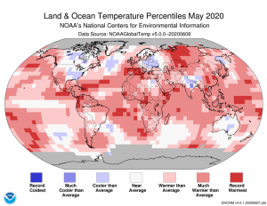 As you might expect, the May 2020 NOAA temperature departure map is mainly red with record warmth over all continents other than Australia, and some cooler weather over central North America, Europe and India.
- The May 2020 NOAA global climate report is out and surprise, it was really warm! In fact, May 2020 was the warmest May on record, tying 2016 at 1.71°F (0.95°C) above the 20th Century temperature average. Here is another shocking statistic, some 7.55% of the world’s surfaces experienced record warmth during May, the third highest percentage since records started in 1951 for this stat. All this as the Trump administration uses the George Floyd protests in the USA to mask a move that makes destroying the environment even easier, disgusting.
- July 1st is National Postal Worker Day so in honor of all of our favorite postmen and postwomen, my Google search of the month was, “USPS and GIS.” And wouldn’t you know it, we found this very timely paper by Stephen Misterek which uses GIS to help plan a USPS response to a simulated anthrax outbreak as I can easily see how this analysis applies to the COVID-19 pandemic.
- In June we reviewed a robust GIS website for South Dakota’s second largest city, Rapid City, and for this edition of our monthly review we travel east to Nashville, Tennessee:
Nashville, TN GIS Website
Nashville, TN GIS Contacts (same site as above as there are no direct contacts unfortunately, check the right side)
Nashville, TN GIS Web Map
Nashville, TN GIS Map Collections
Nashville, TN GIS Direct Downloads (apparently some data is only sold)
Brock Adam McCarty
Map Wizard
(720) 470-7988
brock@apollomapping.com
You might think you’re sneaky and oh so clever, but we’ve caught on to your little game. Under our noses, people are using Image Hunter for all kinds of unintended applications. Now, we’re calling you out and sending you packing to our brand-new website, kmz2shp.com, where you can convert your heart out. Converting between geographic information systems (GIS) file types is a surprise application of Image Hunter so we decided to create a standalone website to better accommodate our customers who use shapefiles (SHP), KMZs, KMLs and GeoJSONs (JSON) and need to convert between them often.
With our new website, kmz2shp.com, you can go to town, converting all of your shapefiles (SHP) into Google’s KMZ or KML formats. And if you’re sitting on a bunch of KMZ and KML files, you can turn them into the open-standard format GeoJSON (JSON) or convert them back to shapefiles to load into a GIS. There’s no limit on how many files you can convert (as long as they are below 10 MBs when zipped); and all of this for the low, low price of free! We hope you find our new website helpful and it saves you the extra step of going to Image Hunter each time you want to convert between a GIS file format.
Every time we look at WorldView-3 and WorldView-4 (WV3/4) imagery, we are blown away. And we hope you are equally impressed with the data! In June we checked out a very cool star fort in Europe, and for the July edition of the 30-cm Color WorldView-3/4 Image of the Month we stay in Europe with a unique look at one of its most historic and picturesque cities, Barcelona, Spain.

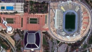

 High off-nadir images are collected at a tilt so that you see a side-view or bird’s eye perspective of a location–they are pretty cool! These high-off nadir images collected by WorldView-4 of Barcelona, Spain highlight a colorful 38-floor building known as Torre Glòries (formerly Torre Agbar), as well as Basílica de la Sagrada Família which is Antoni Gaudi’s unfinished Roman Catholic minor basilica. This about 49-cm WorldView-4 high off-nadir image was collected on March 29, 2017 and has been enhanced by Apollo Mapping for improved perspective, colors and clarity. (Images Courtesy: Maxar)
PLEASE NOTE: Effective May 2016, WorldView-3/4 prices dropped again! Are you interested in finding out more about these price drops? If so, send us an email at sales@apollomapping.com.
WorldView-3 launched in late 2014 and WorldView-4 launched in late 2016; taken together they are the most advanced satellite constellation the commercial marketplace has ever had access to. Here are a few of the features that really set these satellites apart from the competition:
- Improved Resolution
- Higher resolution means you can see more detail in WV3/4 imagery.
- Data collected at nadir will have 31-centimeter (cm) panchromatic, 1.24-meter (m) visible and near infrared, 3.7-m SWIR (WV3 only) and 30-m CAVIS (WV3 only) bands.
- At 20 degrees off-nadir, the resolution is 34-cm panchromatic, 1.38-m visible and near infrared and 4.1-m shortwave infrared.
- Additional Spectral Bands
- If spectral analysis is part of your project, then no other satellite can match WV3 with its: 8 bands of visible and near-infrared data; and 8 shortwave infrared bands which are crucial for geological studies.
- Better Positional Accuracy
- With accuracies of 3.5-m CE90% or better (without ground control even!), WV3/4 has no rivals for its enhanced positional accuracy.
- Daily Revisits
- At 40 degrees latitude, WV3 is able to image every location daily with 1-meter or better resolution and then every 4.5 days at 34-cm resolution or better.
- WV4 is no longer collecting new imagery.
- Increased Collection Capacity
- WV3/4 feature 13.1-km swath widths (at nadir) with the ability to collect up to 680,000 square kilometer (sq km) of high-resolution data per day per satellite (though WV4 is dead now).
- Improved control movement gyros translate into larger maximum contiguous collection areas per pass, with up to ~7,500 sq km of mono imagery and ~3,000 sq km of stereo possible.
If you are interested in WorldView-3 and/or WorldView-4 imagery for your next project, please let us know by phone, 303-993-3863, or by email, sales@apollomapping.com.
You can also find more WV3 samples and technical information on our website here and then WV4 samples and information can be found here.
 This map shows the areas imaged by the WorldView-2/3 constellation from June 1 to August 31, 2019 over Sub-Saharan Africa. Please note that in many instances, multiple images were collected over the same area which is difficult to portray on this static map.
In this monthly piece, we give our readers a sense of the high-resolution imagery coverage collected over a geography during a specified window. To do this, we pick a high-resolution satellite constellation, a defined time period and area of interest, then report key statistics on the total amount of imagery collected in square kilometers (sq km). Without further delay, let’s jump into our analysis.
Graphic Region of Interest: Sub-Saharan Africa plus off-shore islands
Land Mass Covered: 16,510,458.9 sq km
Time Period: June 1 to August 31, 2019
High-Resolution Satellite Constellation: WorldView-2 + WorldView-3
WorldView-2/3 Constellation Imaging Statistics–Sub-Saharan Africa
Total Area Collected: 7,749,331.3 sq km; 42,115.9 sq km per satellite/per day
Area Collected @ 20% or Less Clouds & 30 Degrees or Less Off-Nadir: 3,372,917.0 sq km; 18,331.1 sq km per satellite/per day; 43.5% of total